

237
How Are Networks Used in Geospatial Technology?
to have your starting point and ending point different from one another, and
these types of parameters would have to be placed on the problem. Keep in
mind, with rearranging the order of stops, the program will likely give a decent solution to the problem; however, the only way to truly identify which
configuration is the best would be for the program to work through every possible arrangement—something that would be impossible with a larger number of stops.
How Are Networks Used in Geospatial
Technology?
All of the things discussed in this chapter are used for a variety of applications
with geospatial technology. Through GIS, these types of network data can be
created and utilized in various ways. The vehicle navigation systems integrate
many of these concepts together—using GPS to pinpoint the device’s location
on a map, then using network base data, geocoding, and shortest paths to
navigate through locales worldwide. Other options on these systems involve
utilizing real-time data broadcast into the device to determine areas of congestion, high traffic, construction, or road accidents. This data can then be
used in the shortest-path process to route you around these types of barriers
or things that would slow down your travel. These same maps and technology are being integrated into smartphones to put GPS locations, mapping,
geocoding, shortest-paths, and real-time routing information capabilities into
the palm of your hand (Figure 8.9). As noted, however, often these devices
are only as accurate as the base maps they’re utilizing, so companies provide
a means for consumers to obtain regular map updates or give users the option
to make their own updates.
These same types of network base maps are used online for services
like MapQuest, Bing Maps, Yahoo! Maps, or Google Maps (see Hands-on Application 8.4: Online Mapping and Routing Applications and Shortest Paths),
which allow you to perform geocoding and obtain directions for a shortest
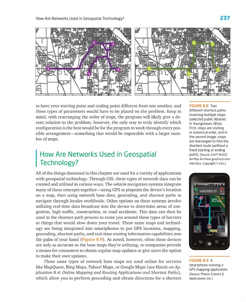
FIGURE 8.8 Two
different shortest paths
involving multiple stops
(selected public libraries
in Youngstown, Ohio):
First, stops are visiting
in numerical order, and in
the second image, stops
are rearranged to find the
shortest route (without a
fixed starting or ending
point). (Source: Esri® ArcGIS
ArcMap ArcView graphical user
interface. Copyright © Esri.)
FIGURE 8.9 A
smartphone running a
GPS mapping application.
(Source: Pharos Science &
Applications, Inc.)
How Are Networks Used in Geospatial Technology?
to have your starting point and ending point different from one another, and
these types of parameters would have to be placed on the problem. Keep in
mind, with rearranging the order of stops, the program will likely give a decent solution to the problem; however, the only way to truly identify which
configuration is the best would be for the program to work through every possible arrangement—something that would be impossible with a larger number of stops.
How Are Networks Used in Geospatial
Technology?
All of the things discussed in this chapter are used for a variety of applications
with geospatial technology. Through GIS, these types of network data can be
created and utilized in various ways. The vehicle navigation systems integrate
many of these concepts together—using GPS to pinpoint the device’s location
on a map, then using network base data, geocoding, and shortest paths to
navigate through locales worldwide. Other options on these systems involve
utilizing real-time data broadcast into the device to determine areas of congestion, high traffic, construction, or road accidents. This data can then be
used in the shortest-path process to route you around these types of barriers
or things that would slow down your travel. These same maps and technology are being integrated into smartphones to put GPS locations, mapping,
geocoding, shortest-paths, and real-time routing information capabilities into
the palm of your hand (Figure 8.9). As noted, however, often these devices
are only as accurate as the base maps they’re utilizing, so companies provide
a means for consumers to obtain regular map updates or give users the option
to make their own updates.
These same types of network base maps are used online for services
like MapQuest, Bing Maps, Yahoo! Maps, or Google Maps (see Hands-on Application 8.4: Online Mapping and Routing Applications and Shortest Paths),
which allow you to perform geocoding and obtain directions for a shortest
FIGURE 8.8 Two
different shortest paths
involving multiple stops
(selected public libraries
in Youngstown, Ohio):
First, stops are visiting
in numerical order, and in
the second image, stops
are rearranged to find the
shortest route (without a
fixed starting or ending
point). (Source: Esri® ArcGIS
ArcMap ArcView graphical user
interface. Copyright © Esri.)
FIGURE 8.9 A
smartphone running a
GPS mapping application.
(Source: Pharos Science &
Applications, Inc.)