

124
Chapter 5 Working With Digital Spatial Data and GIS
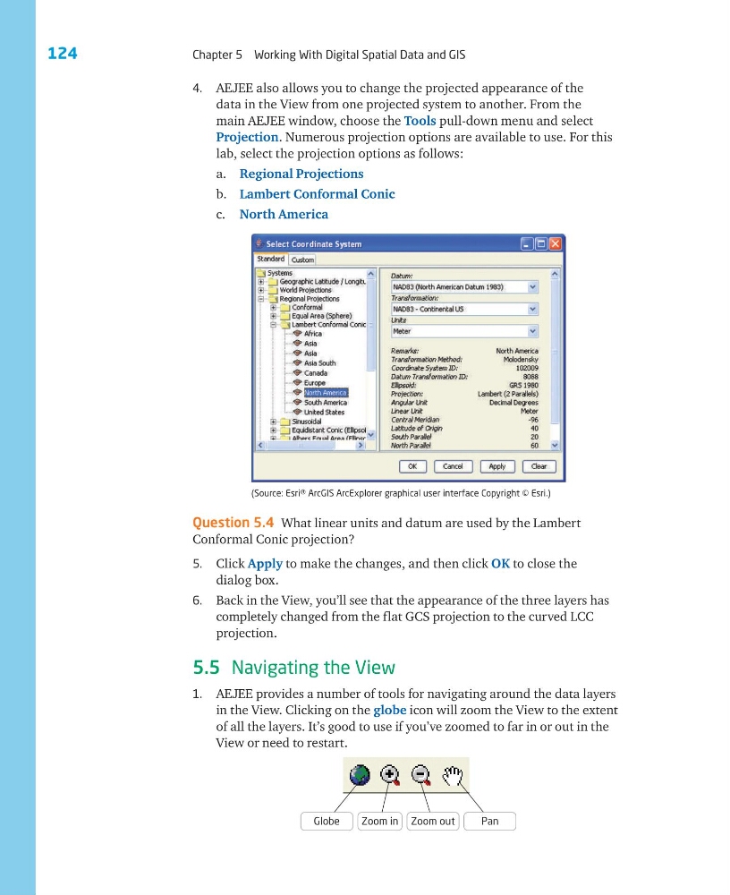
4. AEJEE also allows you to change the projected appearance of the
data in the View from one projected system to another. From the
main AEJEE window, choose the Tools pull-down menu and select
Projection. Numerous projection options are available to use. For this
lab, select the projection options as follows:
a. Regional Projections
b. Lambert Conformal Conic
c. North America
(Source: Esri® ArcGIS ArcExplorer graphical user interface Copyright © Esri.)
Question 5.4 What linear units and datum are used by the Lambert
Conformal Conic projection?
5. Click Apply to make the changes, and then click OK to close the
dialog box.
6. Back in the View, you’ll see that the appearance of the three layers has
completely changed from the flat GCS projection to the curved LCC
projection.
5.5 Navigating the View
1. AEJEE provides a number of tools for navigating around the data layers
in the View. Clicking on the globe icon will zoom the View to the extent
of all the layers. It’s good to use if you’ve zoomed to far in or out in the
View or need to restart.
Globe
Zoom in Zoom out
Pan
Chapter 5 Working With Digital Spatial Data and GIS
4. AEJEE also allows you to change the projected appearance of the
data in the View from one projected system to another. From the
main AEJEE window, choose the Tools pull-down menu and select
Projection. Numerous projection options are available to use. For this
lab, select the projection options as follows:
a. Regional Projections
b. Lambert Conformal Conic
c. North America
(Source: Esri® ArcGIS ArcExplorer graphical user interface Copyright © Esri.)
Question 5.4 What linear units and datum are used by the Lambert
Conformal Conic projection?
5. Click Apply to make the changes, and then click OK to close the
dialog box.
6. Back in the View, you’ll see that the appearance of the three layers has
completely changed from the flat GCS projection to the curved LCC
projection.
5.5 Navigating the View
1. AEJEE provides a number of tools for navigating around the data layers
in the View. Clicking on the globe icon will zoom the View to the extent
of all the layers. It’s good to use if you’ve zoomed to far in or out in the
View or need to restart.
Globe
Zoom in Zoom out
Pan