

120
Chapter 5 Working With Digital Spatial Data and GIS
(or ones nearby) and perform the same measurements and analysis using
those cities more local to you than ones in northeast Ohio.
5.1 An Introduction to ArcExplorer Java Edition for
Educators (AEJEE)
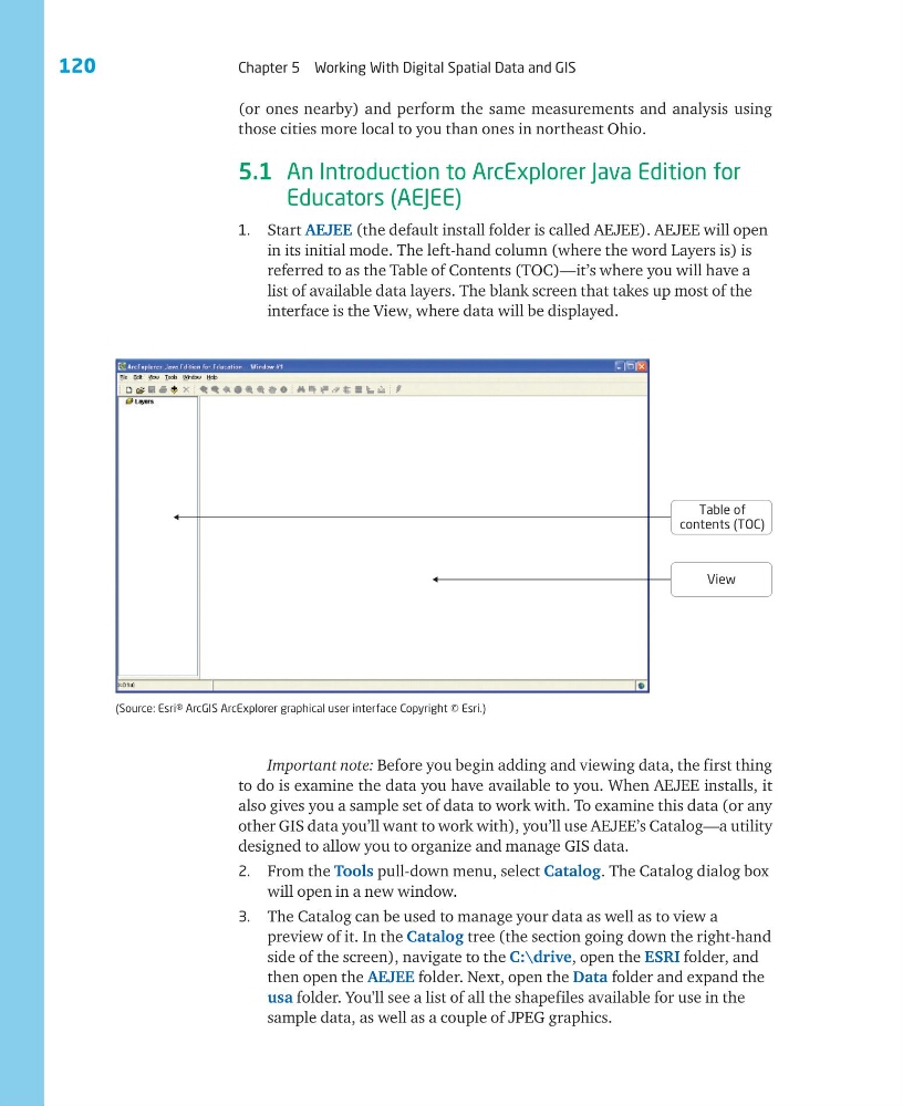
1. Start AEJEE (the default install folder is called AEJEE). AEJEE will open
in its initial mode. The left-hand column (where the word Layers is) is
referred to as the Table of Contents (TOC)—it’s where you will have a
list of available data layers. The blank screen that takes up most of the
interface is the View, where data will be displayed.
Important note: Before you begin adding and viewing data, the first thing
to do is examine the data you have available to you. When AEJEE installs, it
also gives you a sample set of data to work with. To examine this data (or any
other GIS data you’ll want to work with), you’ll use AEJEE’s Catalog—a utility
designed to allow you to organize and manage GIS data.
2. From the Tools pull-down menu, select Catalog. The Catalog dialog box
will open in a new window.
3. The Catalog can be used to manage your data as well as to view a
preview of it. In the Catalog tree (the section going down the right-hand
side of the screen), navigate to the C:\drive, open the ESRI folder, and
then open the AEJEE folder. Next, open the Data folder and expand the
usa folder. You’ll see a list of all the shapefiles available for use in the
sample data, as well as a couple of JPEG graphics.
View
Table of
contents (TOC)
(Source: Esri® ArcGIS ArcExplorer graphical user interface Copyright © Esri.)
Chapter 5 Working With Digital Spatial Data and GIS
(or ones nearby) and perform the same measurements and analysis using
those cities more local to you than ones in northeast Ohio.
5.1 An Introduction to ArcExplorer Java Edition for
Educators (AEJEE)
1. Start AEJEE (the default install folder is called AEJEE). AEJEE will open
in its initial mode. The left-hand column (where the word Layers is) is
referred to as the Table of Contents (TOC)—it’s where you will have a
list of available data layers. The blank screen that takes up most of the
interface is the View, where data will be displayed.
Important note: Before you begin adding and viewing data, the first thing
to do is examine the data you have available to you. When AEJEE installs, it
also gives you a sample set of data to work with. To examine this data (or any
other GIS data you’ll want to work with), you’ll use AEJEE’s Catalog—a utility
designed to allow you to organize and manage GIS data.
2. From the Tools pull-down menu, select Catalog. The Catalog dialog box
will open in a new window.
3. The Catalog can be used to manage your data as well as to view a
preview of it. In the Catalog tree (the section going down the right-hand
side of the screen), navigate to the C:\drive, open the ESRI folder, and
then open the AEJEE folder. Next, open the Data folder and expand the
usa folder. You’ll see a list of all the shapefiles available for use in the
sample data, as well as a couple of JPEG graphics.
View
Table of
contents (TOC)
(Source: Esri® ArcGIS ArcExplorer graphical user interface Copyright © Esri.)