

107
How Can You Represent the Real World as Continuous Fields?
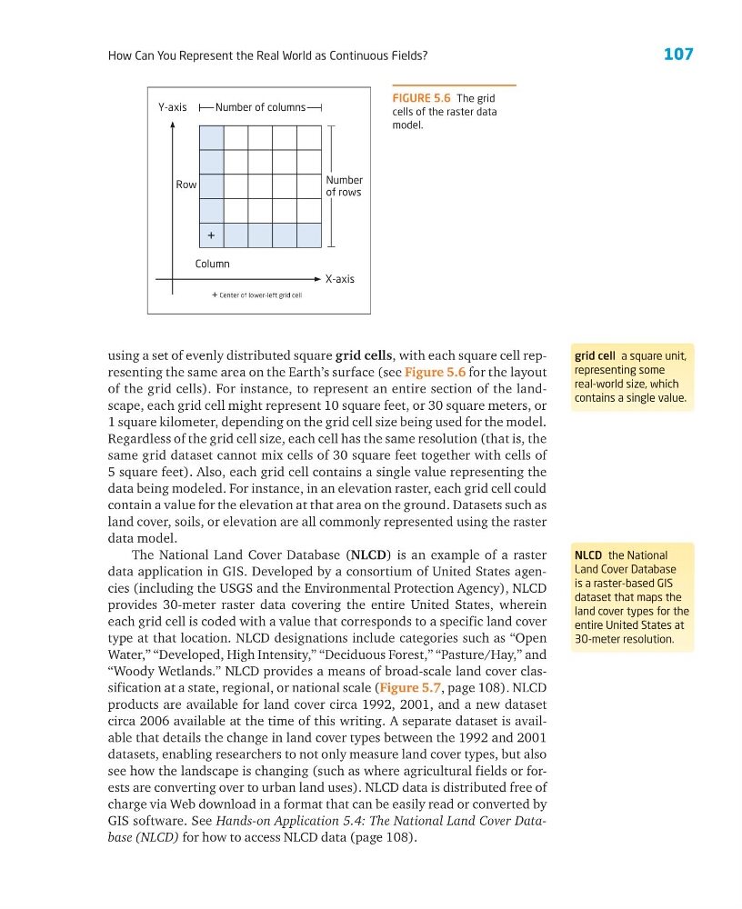
using a set of evenly distributed square grid cells, with each square cell representing the same area on the Earth’s surface (see Figure 5.6 for the layout
of the grid cells). For instance, to represent an entire section of the landscape, each grid cell might represent 10 square feet, or 30 square meters, or
1 square kilometer, depending on the grid cell size being used for the model.
Regardless of the grid cell size, each cell has the same resolution (that is, the
same grid dataset cannot mix cells of 30 square feet together with cells of
5 square feet). Also, each grid cell contains a single value representing the
data being modeled. For instance, in an elevation raster, each grid cell could
contain a value for the elevation at that area on the ground. Datasets such as
land cover, soils, or elevation are all commonly represented using the raster
data model.
The National Land Cover Database (NLCD) is an example of a raster
data application in GIS. Developed by a consortium of United States agencies (including the USGS and the Environmental Protection Agency), NLCD
provides 30-meter raster data covering the entire United States, wherein
each grid cell is coded with a value that corresponds to a specific land cover
type at that location. NLCD designations include categories such as “Open
Water,” “Developed, High Intensity,” “Deciduous Forest,” “Pasture/Hay,” and
“Woody Wetlands.” NLCD provides a means of broad-scale land cover classification at a state, regional, or national scale (Figure 5.7, page 108). NLCD
products are available for land cover circa 1992, 2001, and a new dataset
circa 2006 available at the time of this writing. A separate dataset is available that details the change in land cover types between the 1992 and 2001
datasets, enabling researchers to not only measure land cover types, but also
see how the landscape is changing (such as where agricultural fields or forests are converting over to urban land uses). NLCD data is distributed free of
charge via Web download in a format that can be easily read or converted by
GIS software. See Hands-on Application 5.4: The National Land Cover Database (NLCD) for how to access NLCD data (page 108).
grid cell a square unit,
representing some
real-world size, which
contains a single value.
NLCD the National
Land Cover Database
is a raster-based GIS
dataset that maps the
land cover types for the
entire United States at
30-meter resolution.
FIGURE 5.6 The grid
cells of the raster data
model.
Y-axis
X-axis
Number of columns
Column
+ Center of lower-left grid cell
Row
Number
of rows
+
How Can You Represent the Real World as Continuous Fields?
using a set of evenly distributed square grid cells, with each square cell representing the same area on the Earth’s surface (see Figure 5.6 for the layout
of the grid cells). For instance, to represent an entire section of the landscape, each grid cell might represent 10 square feet, or 30 square meters, or
1 square kilometer, depending on the grid cell size being used for the model.
Regardless of the grid cell size, each cell has the same resolution (that is, the
same grid dataset cannot mix cells of 30 square feet together with cells of
5 square feet). Also, each grid cell contains a single value representing the
data being modeled. For instance, in an elevation raster, each grid cell could
contain a value for the elevation at that area on the ground. Datasets such as
land cover, soils, or elevation are all commonly represented using the raster
data model.
The National Land Cover Database (NLCD) is an example of a raster
data application in GIS. Developed by a consortium of United States agencies (including the USGS and the Environmental Protection Agency), NLCD
provides 30-meter raster data covering the entire United States, wherein
each grid cell is coded with a value that corresponds to a specific land cover
type at that location. NLCD designations include categories such as “Open
Water,” “Developed, High Intensity,” “Deciduous Forest,” “Pasture/Hay,” and
“Woody Wetlands.” NLCD provides a means of broad-scale land cover classification at a state, regional, or national scale (Figure 5.7, page 108). NLCD
products are available for land cover circa 1992, 2001, and a new dataset
circa 2006 available at the time of this writing. A separate dataset is available that details the change in land cover types between the 1992 and 2001
datasets, enabling researchers to not only measure land cover types, but also
see how the landscape is changing (such as where agricultural fields or forests are converting over to urban land uses). NLCD data is distributed free of
charge via Web download in a format that can be easily read or converted by
GIS software. See Hands-on Application 5.4: The National Land Cover Database (NLCD) for how to access NLCD data (page 108).
grid cell a square unit,
representing some
real-world size, which
contains a single value.
NLCD the National
Land Cover Database
is a raster-based GIS
dataset that maps the
land cover types for the
entire United States at
30-meter resolution.
FIGURE 5.6 The grid
cells of the raster data
model.
Y-axis
X-axis
Number of columns
Column
+ Center of lower-left grid cell
Row
Number
of rows
+