

Session 2 : Assessment of irrigation potential in Africa
118
NIWR
CWR S
i
i
n
i
=
⋅
=
∑
1
unit: m
3
(2)
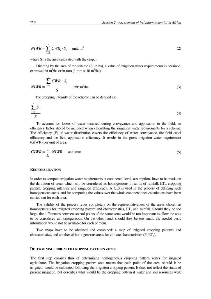
where S i is the area cultivated with the crop, i.
Dividing by the area of the scheme (S, in ha), a value of irrigation water requirements is obtained,
expressed in m
3
/ha or in mm (1 mm = 10 m
3
/ha).
NIWR
CWR S
S
i
i
i
n
=
⋅
=
∑
1
unit: m
3
/ha
(3)
The cropping intensity of the scheme can be defined as:
S
S
i
i
n
=
∑
1
(4)
To account for losses of water incurred during conveyance and application to the field, an
efficiency factor should be included when calculating the irrigation water requirements for a scheme.
The efficiency (E) of water distribution covers the efficiency of water conveyance, the field canal
efficiency and the field application efficiency. It results in the gross irrigation water requirement
(GIWR) per unit of area.
GIWR
E
NIWR
= ⋅
1
unit: mm
(5)
REGIONALIZATION
In order to compute irrigation water requirements at continental level, assumptions have to be made on
the definition of areas which will be considered as homogeneous in terms of rainfall, ET o , cropping
pattern, cropping intensity and irrigation efficiency. A GIS is used in the process of defining such
homogeneous areas, and for computing the values over the whole continent once calculations have been
carried out for each area.
The validity of the process relies completely on the representativeness of the areas chosen as
homogeneous for irrigated cropping pattern and characteristics, ET o and rainfall. Should they be too
large, the differences between several points of the same zone would be too important to allow the area
to be considered as homogeneous. On the other hand, should they be too small, the needed basic
information would not be available for each of them.
Two maps have to be obtained and combined: a map of irrigated cropping patterns and
characteristics, and another of homogeneous areas for climate characteristics (P, ET o ).
DETERMINING IRRIGATED CROPPING PATTERN ZONES
The first step consists thus of determining homogeneous cropping pattern zones for irrigated
agriculture. The irrigation cropping pattern area means that each point of the area, should it be
irrigated, would be cultivated following the irrigation cropping pattern. It does not reflect the status of
present irrigation, but describes what would be the cropping pattern if water and soil resources were
118
NIWR
CWR S
i
i
n
i
=
⋅
=
∑
1
unit: m
3
(2)
where S i is the area cultivated with the crop, i.
Dividing by the area of the scheme (S, in ha), a value of irrigation water requirements is obtained,
expressed in m
3
/ha or in mm (1 mm = 10 m
3
/ha).
NIWR
CWR S
S
i
i
i
n
=
⋅
=
∑
1
unit: m
3
/ha
(3)
The cropping intensity of the scheme can be defined as:
S
S
i
i
n
=
∑
1
(4)
To account for losses of water incurred during conveyance and application to the field, an
efficiency factor should be included when calculating the irrigation water requirements for a scheme.
The efficiency (E) of water distribution covers the efficiency of water conveyance, the field canal
efficiency and the field application efficiency. It results in the gross irrigation water requirement
(GIWR) per unit of area.
GIWR
E
NIWR
= ⋅
1
unit: mm
(5)
REGIONALIZATION
In order to compute irrigation water requirements at continental level, assumptions have to be made on
the definition of areas which will be considered as homogeneous in terms of rainfall, ET o , cropping
pattern, cropping intensity and irrigation efficiency. A GIS is used in the process of defining such
homogeneous areas, and for computing the values over the whole continent once calculations have been
carried out for each area.
The validity of the process relies completely on the representativeness of the areas chosen as
homogeneous for irrigated cropping pattern and characteristics, ET o and rainfall. Should they be too
large, the differences between several points of the same zone would be too important to allow the area
to be considered as homogeneous. On the other hand, should they be too small, the needed basic
information would not be available for each of them.
Two maps have to be obtained and combined: a map of irrigated cropping patterns and
characteristics, and another of homogeneous areas for climate characteristics (P, ET o ).
DETERMINING IRRIGATED CROPPING PATTERN ZONES
The first step consists thus of determining homogeneous cropping pattern zones for irrigated
agriculture. The irrigation cropping pattern area means that each point of the area, should it be
irrigated, would be cultivated following the irrigation cropping pattern. It does not reflect the status of
present irrigation, but describes what would be the cropping pattern if water and soil resources were