

image object, the undersegmentation is always a very poor image segmentation
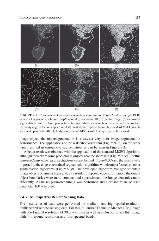
performance. The applications of the watershed algorithm (Figure 9.3c), on the other
hand, resulted in serious oversegmentation, as can be seen in Figure 9.3.
A better result was obtained with the application of the standard MSEG algorithm,
although there were some problems in objects near the shore line (Figure 9.3e). For this
reason a Canny edge feature extraction was performed (Figure 9.3d) and the results were
imported to the edge-constrained segmentation algorithm, which outperformed all other
segmentation algorithms (Figure 9.3f). The developed algorithm managed to obtain
image objects of similar scale and, as a result of imposed edge information, the output
object boundaries were more compact and approximated the image semantics more
efficiently. Again no parameter tuning was performed and a default value of scale
parameter 100 was used.
9.4.3 Multispectral Remote Sensing Data
The next series of tests were performed on medium- and high-spatial-resolution
multispectral remote sensing data. For this, a Landsat Thematic Mapper (TM) image
with pixel spatial resolution of 30 m was used as well as a QuickBird satellite image
with 1 m ground resolution and four spectral bands.
FIGURE 9.3 Comparison of various segmentation algorithms on TerraSAR-X (copyright DLR)
data set (3 m ground resolution, StripMap mode, polarization HH): (a) initial image; (b) mean-shift
segmantation with default parameters; (c) watershed segmentation with default parameters;
(d) canny edge detection applied on AML scale-space representation; (e) standard MSEG results
with scale parameter 400; ( f ) edge-constrained MSEG with Canny edge features used.
EVALUATION AND DISCUSSION
187
performance. The applications of the watershed algorithm (Figure 9.3c), on the other
hand, resulted in serious oversegmentation, as can be seen in Figure 9.3.
A better result was obtained with the application of the standard MSEG algorithm,
although there were some problems in objects near the shore line (Figure 9.3e). For this
reason a Canny edge feature extraction was performed (Figure 9.3d) and the results were
imported to the edge-constrained segmentation algorithm, which outperformed all other
segmentation algorithms (Figure 9.3f). The developed algorithm managed to obtain
image objects of similar scale and, as a result of imposed edge information, the output
object boundaries were more compact and approximated the image semantics more
efficiently. Again no parameter tuning was performed and a default value of scale
parameter 100 was used.
9.4.3 Multispectral Remote Sensing Data
The next series of tests were performed on medium- and high-spatial-resolution
multispectral remote sensing data. For this, a Landsat Thematic Mapper (TM) image
with pixel spatial resolution of 30 m was used as well as a QuickBird satellite image
with 1 m ground resolution and four spectral bands.
FIGURE 9.3 Comparison of various segmentation algorithms on TerraSAR-X (copyright DLR)
data set (3 m ground resolution, StripMap mode, polarization HH): (a) initial image; (b) mean-shift
segmantation with default parameters; (c) watershed segmentation with default parameters;
(d) canny edge detection applied on AML scale-space representation; (e) standard MSEG results
with scale parameter 400; ( f ) edge-constrained MSEG with Canny edge features used.
EVALUATION AND DISCUSSION
187