

The distribution of diversity: challenges and applications
79
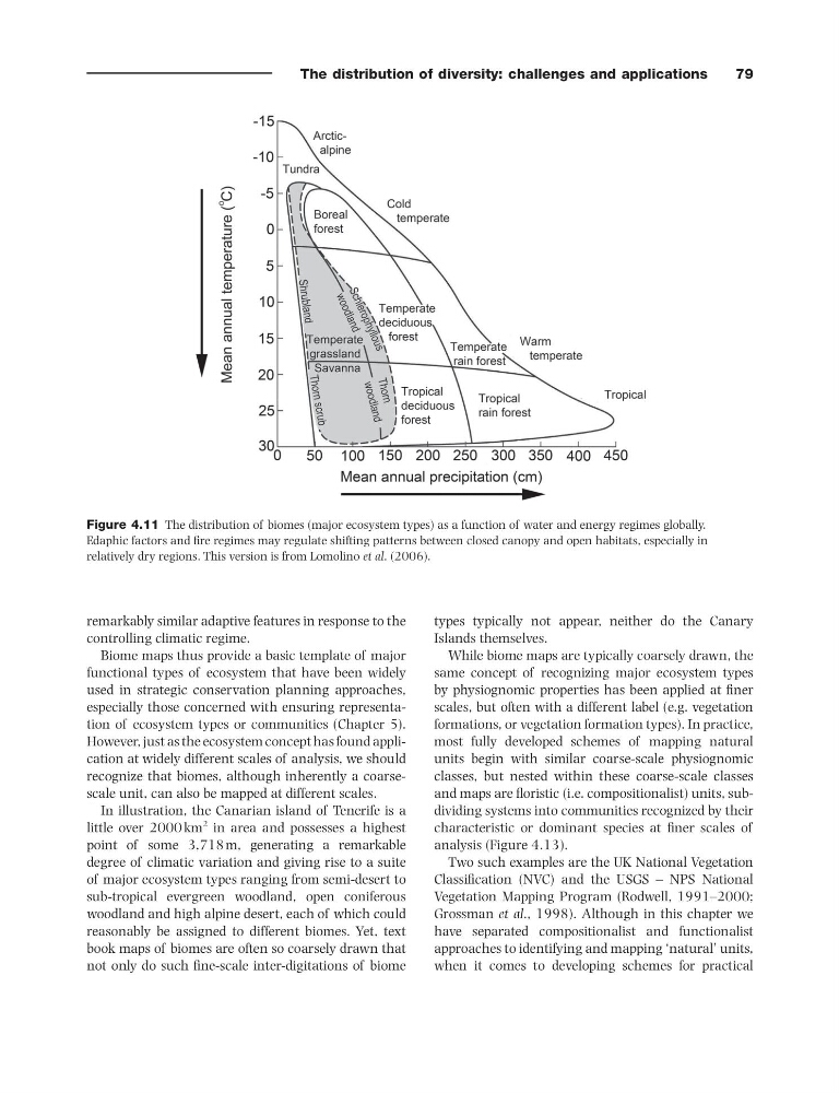
Figure 4.11 The distribution of biomes (major ecosystem types) as a function of water and energy regimes globally.
Edaphic factors and fi re regimes may regulate shifting patterns between closed canopy and open habitats, especially in
relatively dry regions. This version is from Lomolino et al . (2006).
remarkably similar adaptive features in response to the
controlling climatic regime.
Biome maps thus provide a basic template of major
functional types of ecosystem that have been widely
used in strategic conservation planning approaches,
especially those concerned with ensuring representation of ecosystem types or communities (Chapter 5 ).
However, just as the ecosystem concept has found application at widely different scales of analysis, we should
recognize that biomes, although inherently a coarse -
scale unit, can also be mapped at different scales.
In illustration, the Canarian island of Tenerife is a
little over 2000 km
2 in area and possesses a highest
point of some 3,718 m, generating a remarkable
degree of climatic variation and giving rise to a suite
of major ecosystem types ranging from semi - desert to
sub - tropical evergreen woodland, open coniferous
woodland and high alpine desert, each of which could
reasonably be assigned to different biomes. Yet, text
book maps of biomes are often so coarsely drawn that
not only do such fi ne - scale inter - digitations of biome
types typically not appear, neither do the Canary
Islands themselves.
While biome maps are typically coarsely drawn, the
same concept of recognizing major ecosystem types
by physiognomic properties has been applied at fi ner
scales, but often with a different label (e.g. vegetation
formations, or vegetation formation types). In practice,
most fully developed schemes of mapping natural
units begin with similar coarse - scale physiognomic
classes, but nested within these coarse - scale classes
and maps are fl oristic (i.e. compositionalist) units, subdividing systems into communities recognized by their
characteristic or dominant species at fi ner scales of
analysis (Figure 4.13 ).
Two such examples are the UK National Vegetation
Classifi cation (NVC) and the USGS – NPS National
Vegetation Mapping Program (Rodwell, 1991 – 2000 ;
Grossman et al ., 1998 ). Although in this chapter we
have separated compositionalist and functionalist
approaches to identifying and mapping ‘ natural ’ units,
when it comes to developing schemes for practical
79
Figure 4.11 The distribution of biomes (major ecosystem types) as a function of water and energy regimes globally.
Edaphic factors and fi re regimes may regulate shifting patterns between closed canopy and open habitats, especially in
relatively dry regions. This version is from Lomolino et al . (2006).
remarkably similar adaptive features in response to the
controlling climatic regime.
Biome maps thus provide a basic template of major
functional types of ecosystem that have been widely
used in strategic conservation planning approaches,
especially those concerned with ensuring representation of ecosystem types or communities (Chapter 5 ).
However, just as the ecosystem concept has found application at widely different scales of analysis, we should
recognize that biomes, although inherently a coarse -
scale unit, can also be mapped at different scales.
In illustration, the Canarian island of Tenerife is a
little over 2000 km
2 in area and possesses a highest
point of some 3,718 m, generating a remarkable
degree of climatic variation and giving rise to a suite
of major ecosystem types ranging from semi - desert to
sub - tropical evergreen woodland, open coniferous
woodland and high alpine desert, each of which could
reasonably be assigned to different biomes. Yet, text
book maps of biomes are often so coarsely drawn that
not only do such fi ne - scale inter - digitations of biome
types typically not appear, neither do the Canary
Islands themselves.
While biome maps are typically coarsely drawn, the
same concept of recognizing major ecosystem types
by physiognomic properties has been applied at fi ner
scales, but often with a different label (e.g. vegetation
formations, or vegetation formation types). In practice,
most fully developed schemes of mapping natural
units begin with similar coarse - scale physiognomic
classes, but nested within these coarse - scale classes
and maps are fl oristic (i.e. compositionalist) units, subdividing systems into communities recognized by their
characteristic or dominant species at fi ner scales of
analysis (Figure 4.13 ).
Two such examples are the UK National Vegetation
Classifi cation (NVC) and the USGS – NPS National
Vegetation Mapping Program (Rodwell, 1991 – 2000 ;
Grossman et al ., 1998 ). Although in this chapter we
have separated compositionalist and functionalist
approaches to identifying and mapping ‘ natural ’ units,
when it comes to developing schemes for practical