

The distribution of diversity: challenges and applications
97
geography and governance (Mace et al ., 2000 ), a combination of approaches is likely to be most effective for
conservation in the long run. It is thus of benefi t to
conservation that differing protected area networks
exist for particular areas and frequently overlap one
another in designating the same places within multiple
protected area frameworks.
5.2.1 Spatial c lassifi cation of a pproaches
– c ontiguous a reas, l andscape u nits and
h abitat i slands
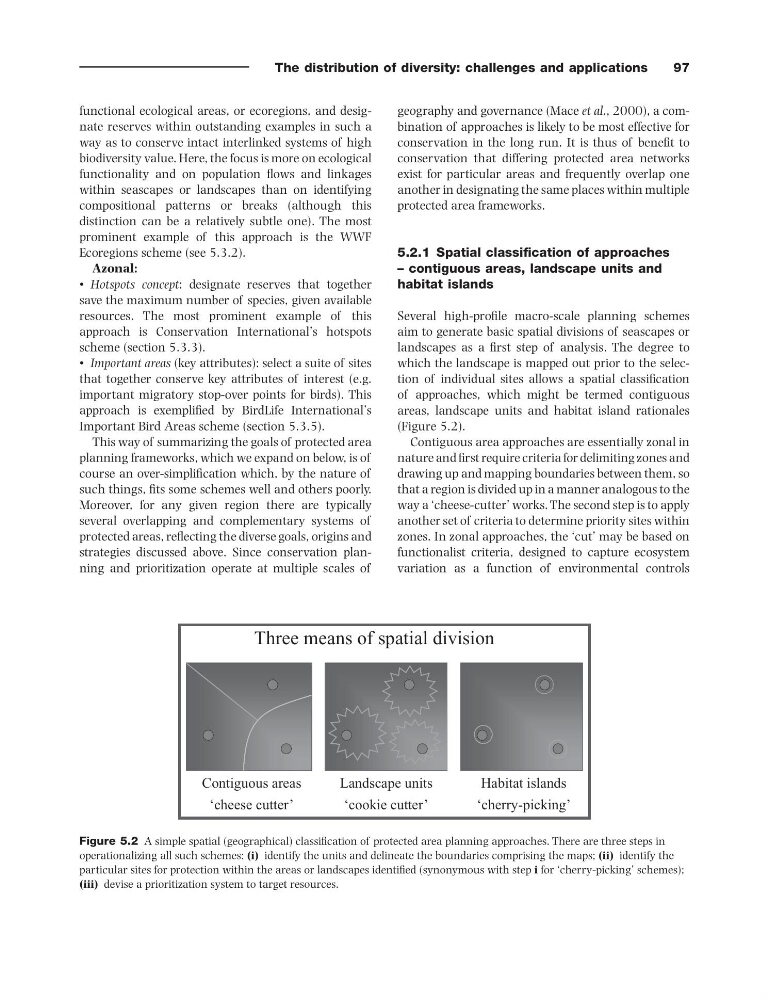
Several high - profi le macro - scale planning schemes
aim to generate basic spatial divisions of seascapes or
landscapes as a fi rst step of analysis. The degree to
which the landscape is mapped out prior to the selection of individual sites allows a spatial classifi cation
of approaches, which might be termed contiguous
areas, landscape units and habitat island rationales
(Figure 5.2 ).
Contiguous area approaches are essentially zonal in
nature and fi rst require criteria for delimiting zones and
drawing up and mapping boundaries between them, so
that a region is divided up in a manner analogous to the
way a ‘ cheese - cutter ’ works. The second step is to apply
another set of criteria to determine priority sites within
zones. In zonal approaches, the ‘ cut ’ may be based on
functionalist criteria, designed to capture ecosystem
variation as a function of environmental controls
functional ecological areas, or ecoregions, and designate reserves within outstanding examples in such a
way as to conserve intact interlinked systems of high
biodiversity value. Here, the focus is more on ecological
functionality and on population fl ows and linkages
within seascapes or landscapes than on identifying
compositional patterns or breaks (although this
distinction can be a relatively subtle one). The most
prominent example of this approach is the WWF
Ecoregions scheme (see 5.3.2).
Azonal:
• Hotspots concept : designate reserves that together
save the maximum number of species, given available
resources. The most prominent example of this
approach is Conservation International ’ s hotspots
scheme (section 5.3.3 ).
• Important areas (key attributes): select a suite of sites
that together conserve key attributes of interest (e.g.
important migratory stop - over points for birds). This
approach is exemplifi ed by BirdLife International ’ s
Important Bird Areas scheme (section 5.3.5 ).
This way of summarizing the goals of protected area
planning frameworks, which we expand on below, is of
course an over - simplifi cation which, by the nature of
such things, fi ts some schemes well and others poorly.
Moreover, for any given region there are typically
several overlapping and complementary systems of
protected areas, refl ecting the diverse goals, origins and
strategies discussed above. Since conservation planning and prioritization operate at multiple scales of
Figure 5.2 A simple spatial (geographical) classifi cation of protected area planning approaches. There are three steps in
operationalizing all such schemes: (i) identify the units and delineate the boundaries comprising the maps; (ii) identify the
particular sites for protection within the areas or landscapes identifi ed (synonymous with step i for ‘ cherry - picking ’ schemes);
(iii) devise a prioritization system to target resources.
Three means of spatial division
Contiguous areas
‘cheese cutter’
Habitat islands
‘cherry-picking’
Landscape units
‘cookie cutter’
97
geography and governance (Mace et al ., 2000 ), a combination of approaches is likely to be most effective for
conservation in the long run. It is thus of benefi t to
conservation that differing protected area networks
exist for particular areas and frequently overlap one
another in designating the same places within multiple
protected area frameworks.
5.2.1 Spatial c lassifi cation of a pproaches
– c ontiguous a reas, l andscape u nits and
h abitat i slands
Several high - profi le macro - scale planning schemes
aim to generate basic spatial divisions of seascapes or
landscapes as a fi rst step of analysis. The degree to
which the landscape is mapped out prior to the selection of individual sites allows a spatial classifi cation
of approaches, which might be termed contiguous
areas, landscape units and habitat island rationales
(Figure 5.2 ).
Contiguous area approaches are essentially zonal in
nature and fi rst require criteria for delimiting zones and
drawing up and mapping boundaries between them, so
that a region is divided up in a manner analogous to the
way a ‘ cheese - cutter ’ works. The second step is to apply
another set of criteria to determine priority sites within
zones. In zonal approaches, the ‘ cut ’ may be based on
functionalist criteria, designed to capture ecosystem
variation as a function of environmental controls
functional ecological areas, or ecoregions, and designate reserves within outstanding examples in such a
way as to conserve intact interlinked systems of high
biodiversity value. Here, the focus is more on ecological
functionality and on population fl ows and linkages
within seascapes or landscapes than on identifying
compositional patterns or breaks (although this
distinction can be a relatively subtle one). The most
prominent example of this approach is the WWF
Ecoregions scheme (see 5.3.2).
Azonal:
• Hotspots concept : designate reserves that together
save the maximum number of species, given available
resources. The most prominent example of this
approach is Conservation International ’ s hotspots
scheme (section 5.3.3 ).
• Important areas (key attributes): select a suite of sites
that together conserve key attributes of interest (e.g.
important migratory stop - over points for birds). This
approach is exemplifi ed by BirdLife International ’ s
Important Bird Areas scheme (section 5.3.5 ).
This way of summarizing the goals of protected area
planning frameworks, which we expand on below, is of
course an over - simplifi cation which, by the nature of
such things, fi ts some schemes well and others poorly.
Moreover, for any given region there are typically
several overlapping and complementary systems of
protected areas, refl ecting the diverse goals, origins and
strategies discussed above. Since conservation planning and prioritization operate at multiple scales of
Figure 5.2 A simple spatial (geographical) classifi cation of protected area planning approaches. There are three steps in
operationalizing all such schemes: (i) identify the units and delineate the boundaries comprising the maps; (ii) identify the
particular sites for protection within the areas or landscapes identifi ed (synonymous with step i for ‘ cherry - picking ’ schemes);
(iii) devise a prioritization system to target resources.
Three means of spatial division
Contiguous areas
‘cheese cutter’
Habitat islands
‘cherry-picking’
Landscape units
‘cookie cutter’