

88
Basic biogeography: estimating biodiversity and mapping nature
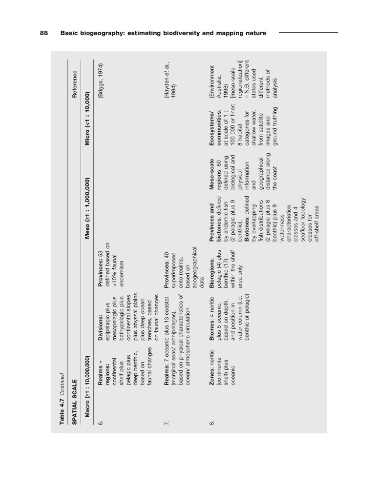
Table 4.7
Continued
SPATIAL SCALE
Reference
Macro (≥1 : 10,000,000)
Meso (≥1 : 1,000,000)
Micro (<1 : 10,000)
6.
Realms +
regions:
continental
shelf plus
pelagic plus
deep benthic,
based on
faunal changes
Divisions:
epipelagic plus
mesopelagic plus
bathypelagic plus
continental slopes
plus abyssal
plains
plus deep ocean
trenches,
based
on faunal changes
Provinces:
53
defined based on
>10%
faunal
endemism
(Briggs, 1974)
7.
Realms:
7 oceanic plus 13 coastal
(marginal seas/ archipelagos),
based on physical characteristics
of
ocean/ atmospheric circulation
Provinces:
40
superimposed
onto realms,
based on
zoogeographical
data
(Hayden et al.,
1984)
8.
Zones:
neritic
(continental
shelf) plus
oceanic
Biomes:
4 neritic
plus
5 oceanic,
based on depth,
and position in
water column
(i.e.
benthic or
pelagic)
Bioregions:
pelagic (4) plus
benthic
(17)
within the
shelf
area only
Provinces and
biotones:
defined
by endemic fish
(2 pelagic plus
9
benthic);
Biotones:
defined
by overlapping
fish distributions
(2
pelagic plus
8
benthic)
plus 9
watermass
characteristics
classes and 4
seafloor topology
classes for
off-shelf areas
Meso-scale
regions:
60
defined using
biological and
physical
information
and
geographical
distance along
the coast
Ecosystems/
communities:
at scale of 1 :
100 000
or finer;
8
habitat
categories for
shallow water,
from
satellite
images
and
ground
truthing
(Environment
Australia,
1998)
[meso-scale
regionalization]
–
N.B. different
states used
different
methods of
analysis
Basic biogeography: estimating biodiversity and mapping nature
Table 4.7
Continued
SPATIAL SCALE
Reference
Macro (≥1 : 10,000,000)
Meso (≥1 : 1,000,000)
Micro (<1 : 10,000)
6.
Realms +
regions:
continental
shelf plus
pelagic plus
deep benthic,
based on
faunal changes
Divisions:
epipelagic plus
mesopelagic plus
bathypelagic plus
continental slopes
plus abyssal
plains
plus deep ocean
trenches,
based
on faunal changes
Provinces:
53
defined based on
>10%
faunal
endemism
(Briggs, 1974)
7.
Realms:
7 oceanic plus 13 coastal
(marginal seas/ archipelagos),
based on physical characteristics
of
ocean/ atmospheric circulation
Provinces:
40
superimposed
onto realms,
based on
zoogeographical
data
(Hayden et al.,
1984)
8.
Zones:
neritic
(continental
shelf) plus
oceanic
Biomes:
4 neritic
plus
5 oceanic,
based on depth,
and position in
water column
(i.e.
benthic or
pelagic)
Bioregions:
pelagic (4) plus
benthic
(17)
within the
shelf
area only
Provinces and
biotones:
defined
by endemic fish
(2 pelagic plus
9
benthic);
Biotones:
defined
by overlapping
fish distributions
(2
pelagic plus
8
benthic)
plus 9
watermass
characteristics
classes and 4
seafloor topology
classes for
off-shelf areas
Meso-scale
regions:
60
defined using
biological and
physical
information
and
geographical
distance along
the coast
Ecosystems/
communities:
at scale of 1 :
100 000
or finer;
8
habitat
categories for
shallow water,
from
satellite
images
and
ground
truthing
(Environment
Australia,
1998)
[meso-scale
regionalization]
–
N.B. different
states used
different
methods of
analysis