

272
Paul A. TYLER
95º
90º
85º
80º
20º
25º
30º
MEXICO
Mississippi
River
Cuba
Yucatan
Peninsula
20º
25º
30º
N
95º
90º
85º
80ºW
#
C A M P E C H E
C A R B O N A T E S
F L O R I D A
C A R B O N A T E S
I
Florida
III
IV
V
II
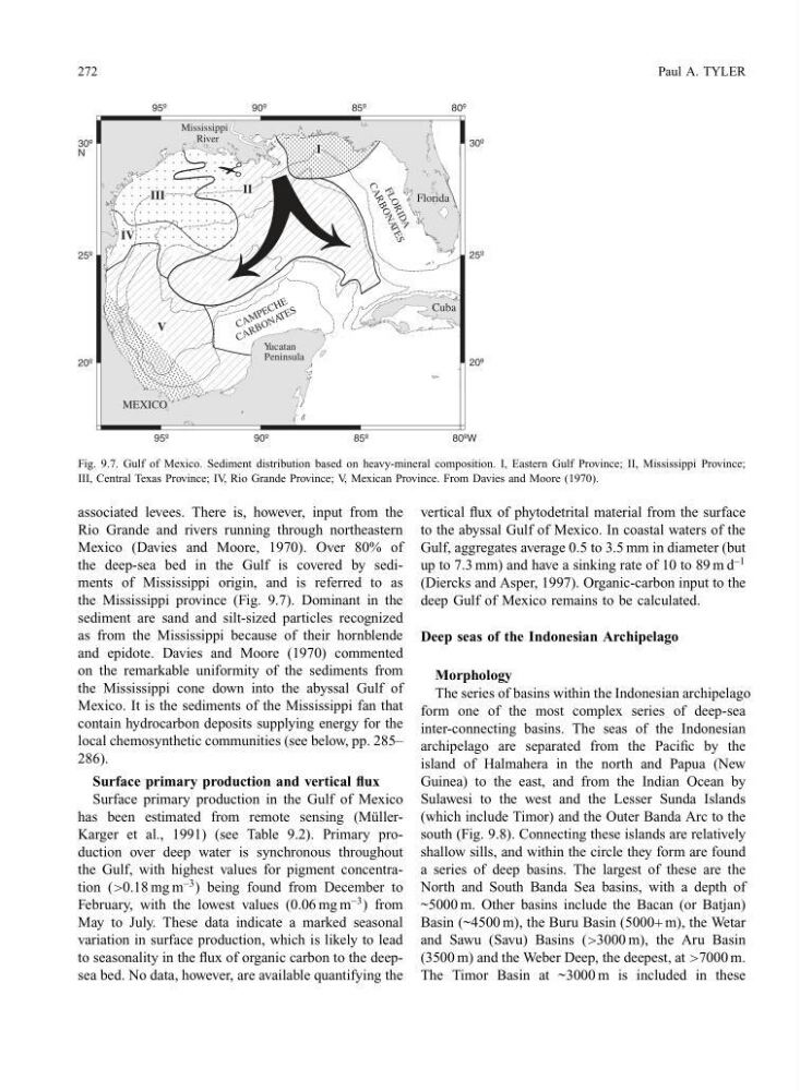
Fig. 9.7. Gulf of Mexico. Sediment distribution based on heavy-mineral composition. I, Eastern Gulf Province; II, Mississippi Province;
III, Central Texas Province; IV, Rio Grande Province; V, Mexican Province. From Davies and Moore (1970).
associated levees. There is, however, input from the
Rio Grande and rivers running through northeastern
Mexico (Davies and Moore, 1970). Over 80% of
the deep-sea bed in the Gulf is covered by sediments of Mississippi origin, and is referred to as
the Mississippi province (Fig. 9.7). Dominant in the
sediment are sand and silt-sized particles recognized
as from the Mississippi because of their hornblende
and epidote. Davies and Moore (1970) commented
on the remarkable uniformity of the sediments from
the Mississippi cone down into the abyssal Gulf of
Mexico. It is the sediments of the Mississippi fan that
contain hydrocarbon deposits supplying energy for the
local chemosynthetic communities (see below, pp. 285–
286).
Surface primary production and vertical flux
Surface primary production in the Gulf of Mexico
has been estimated from remote sensing (M¨ ullerKarger et al., 1991) (see Table 9.2). Primary production over deep water is synchronous throughout
the Gulf, with highest values for pigment concentration (>0.18 mg m
−3 ) being found from December to
February, with the lowest values (0.06 mg m
−3 ) from
May to July. These data indicate a marked seasonal
variation in surface production, which is likely to lead
to seasonality in the flux of organic carbon to the deepsea bed. No data, however, are available quantifying the
vertical flux of phytodetrital material from the surface
to the abyssal Gulf of Mexico. In coastal waters of the
Gulf, aggregates average 0.5 to 3.5 mm in diameter (but
up to 7.3 mm) and have a sinking rate of 10 to 89 m d
−1
(Diercks and Asper, 1997). Organic-carbon input to the
deep Gulf of Mexico remains to be calculated.
Deep seas of the Indonesian Archipelago
Morphology
The series of basins within the Indonesian archipelago
form one of the most complex series of deep-sea
inter-connecting basins. The seas of the Indonesian
archipelago are separated from the Pacific by the
island of Halmahera in the north and Papua (New
Guinea) to the east, and from the Indian Ocean by
Sulawesi to the west and the Lesser Sunda Islands
(which include Timor) and the Outer Banda Arc to the
south (Fig. 9.8). Connecting these islands are relatively
shallow sills, and within the circle they form are found
a series of deep basins. The largest of these are the
North and South Banda Sea basins, with a depth of
~5000 m. Other basins include the Bacan (or Batjan)
Basin (~4500 m), the Buru Basin (5000+ m), the Wetar
and Sawu (Savu) Basins (>3000 m), the Aru Basin
(3500 m) and the Weber Deep, the deepest, at >7000 m.
The Timor Basin at ~3000 m is included in these
Paul A. TYLER
95º
90º
85º
80º
20º
25º
30º
MEXICO
Mississippi
River
Cuba
Yucatan
Peninsula
20º
25º
30º
N
95º
90º
85º
80ºW
#
C A M P E C H E
C A R B O N A T E S
F L O R I D A
C A R B O N A T E S
I
Florida
III
IV
V
II
Fig. 9.7. Gulf of Mexico. Sediment distribution based on heavy-mineral composition. I, Eastern Gulf Province; II, Mississippi Province;
III, Central Texas Province; IV, Rio Grande Province; V, Mexican Province. From Davies and Moore (1970).
associated levees. There is, however, input from the
Rio Grande and rivers running through northeastern
Mexico (Davies and Moore, 1970). Over 80% of
the deep-sea bed in the Gulf is covered by sediments of Mississippi origin, and is referred to as
the Mississippi province (Fig. 9.7). Dominant in the
sediment are sand and silt-sized particles recognized
as from the Mississippi because of their hornblende
and epidote. Davies and Moore (1970) commented
on the remarkable uniformity of the sediments from
the Mississippi cone down into the abyssal Gulf of
Mexico. It is the sediments of the Mississippi fan that
contain hydrocarbon deposits supplying energy for the
local chemosynthetic communities (see below, pp. 285–
286).
Surface primary production and vertical flux
Surface primary production in the Gulf of Mexico
has been estimated from remote sensing (M¨ ullerKarger et al., 1991) (see Table 9.2). Primary production over deep water is synchronous throughout
the Gulf, with highest values for pigment concentration (>0.18 mg m
−3 ) being found from December to
February, with the lowest values (0.06 mg m
−3 ) from
May to July. These data indicate a marked seasonal
variation in surface production, which is likely to lead
to seasonality in the flux of organic carbon to the deepsea bed. No data, however, are available quantifying the
vertical flux of phytodetrital material from the surface
to the abyssal Gulf of Mexico. In coastal waters of the
Gulf, aggregates average 0.5 to 3.5 mm in diameter (but
up to 7.3 mm) and have a sinking rate of 10 to 89 m d
−1
(Diercks and Asper, 1997). Organic-carbon input to the
deep Gulf of Mexico remains to be calculated.
Deep seas of the Indonesian Archipelago
Morphology
The series of basins within the Indonesian archipelago
form one of the most complex series of deep-sea
inter-connecting basins. The seas of the Indonesian
archipelago are separated from the Pacific by the
island of Halmahera in the north and Papua (New
Guinea) to the east, and from the Indian Ocean by
Sulawesi to the west and the Lesser Sunda Islands
(which include Timor) and the Outer Banda Arc to the
south (Fig. 9.8). Connecting these islands are relatively
shallow sills, and within the circle they form are found
a series of deep basins. The largest of these are the
North and South Banda Sea basins, with a depth of
~5000 m. Other basins include the Bacan (or Batjan)
Basin (~4500 m), the Buru Basin (5000+ m), the Wetar
and Sawu (Savu) Basins (>3000 m), the Aru Basin
(3500 m) and the Weber Deep, the deepest, at >7000 m.
The Timor Basin at ~3000 m is included in these