

THE POLAR DEEP SEAS
241
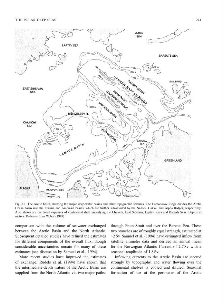
Fig. 8.1. The Arctic basin, showing the major deep-water basins and other topographic features. The Lomonosov Ridge divides the Arctic
Ocean basin into the Eurasia and Amerasia basins, which are further sub-divided by the Nansen–Gakkel and Alpha Ridges, respectively.
Also shown are the broad expanses of continental shelf underlying the Chukchi, East Siberian, Laptev, Kara and Barents Seas. Depths in
metres. Redrawn from Weber (1989).
comparison with the volume of seawater exchanged
between the Arctic Basin and the North Atlantic.
Subsequent detailed studies have refined the estimates
for different components of the overall flux, though
considerable uncertainties remain for many of these
estimates (see discussion by Samuel et al., 1994).
More recent studies have improved the estimates
of exchange. Rudels et al. (1994) have shown that
the intermediate-depth waters of the Arctic Basin are
supplied from the North Atlantic via two major paths:
through Fram Strait and over the Barents Sea. These
two branches are of roughly equal strength, estimated at
~2 Sv. Samuel et al. (1994) have estimated inflow from
satellite altimeter data and derived an annual mean
for the Norwegian Atlantic Current of 2.7 Sv with a
seasonal amplitude of 1.8 Sv.
Inflowing currents to the Arctic Basin are steered
strongly by topography, and water flowing over the
continental shelves is cooled and diluted. Seasonal
formation of ice at the perimeter of the Arctic
241
Fig. 8.1. The Arctic basin, showing the major deep-water basins and other topographic features. The Lomonosov Ridge divides the Arctic
Ocean basin into the Eurasia and Amerasia basins, which are further sub-divided by the Nansen–Gakkel and Alpha Ridges, respectively.
Also shown are the broad expanses of continental shelf underlying the Chukchi, East Siberian, Laptev, Kara and Barents Seas. Depths in
metres. Redrawn from Weber (1989).
comparison with the volume of seawater exchanged
between the Arctic Basin and the North Atlantic.
Subsequent detailed studies have refined the estimates
for different components of the overall flux, though
considerable uncertainties remain for many of these
estimates (see discussion by Samuel et al., 1994).
More recent studies have improved the estimates
of exchange. Rudels et al. (1994) have shown that
the intermediate-depth waters of the Arctic Basin are
supplied from the North Atlantic via two major paths:
through Fram Strait and over the Barents Sea. These
two branches are of roughly equal strength, estimated at
~2 Sv. Samuel et al. (1994) have estimated inflow from
satellite altimeter data and derived an annual mean
for the Norwegian Atlantic Current of 2.7 Sv with a
seasonal amplitude of 1.8 Sv.
Inflowing currents to the Arctic Basin are steered
strongly by topography, and water flowing over the
continental shelves is cooled and diluted. Seasonal
formation of ice at the perimeter of the Arctic