

THE DEEP INDIAN OCEAN FLOOR
221
20°
10°
0°
20°
30°
40°
50°
120°
100°
80°
60°
40°
20°
S
N
10°
E
E
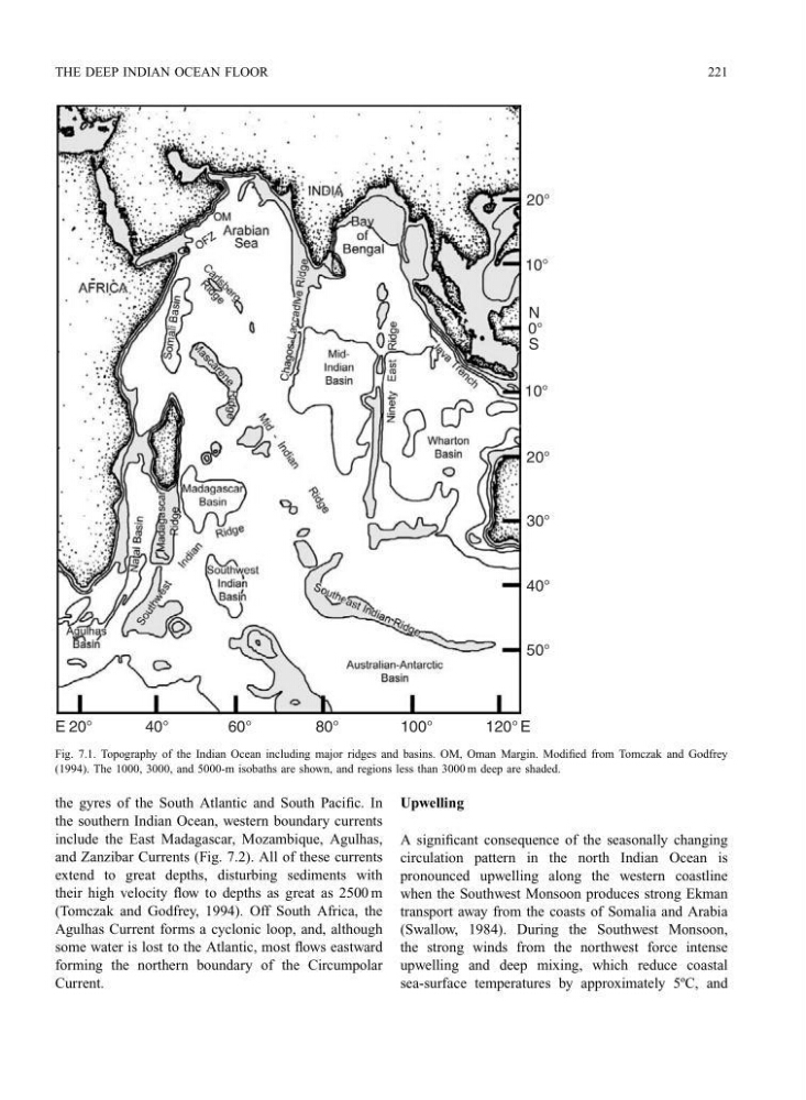
Fig. 7.1. Topography of the Indian Ocean including major ridges and basins. OM, Oman Margin. Modified from Tomczak and Godfrey
(1994). The 1000, 3000, and 5000-m isobaths are shown, and regions less than 3000 m deep are shaded.
the gyres of the South Atlantic and South Pacific. In
the southern Indian Ocean, western boundary currents
include the East Madagascar, Mozambique, Agulhas,
and Zanzibar Currents (Fig. 7.2). All of these currents
extend to great depths, disturbing sediments with
their high velocity flow to depths as great as 2500 m
(Tomczak and Godfrey, 1994). Off South Africa, the
Agulhas Current forms a cyclonic loop, and, although
some water is lost to the Atlantic, most flows eastward
forming the northern boundary of the Circumpolar
Current.
Upwelling
A significant consequence of the seasonally changing
circulation pattern in the north Indian Ocean is
pronounced upwelling along the western coastline
when the Southwest Monsoon produces strong Ekman
transport away from the coasts of Somalia and Arabia
(Swallow, 1984). During the Southwest Monsoon,
the strong winds from the northwest force intense
upwelling and deep mixing, which reduce coastal
sea-surface temperatures by approximately 5ºC, and
221
20°
10°
0°
20°
30°
40°
50°
120°
100°
80°
60°
40°
20°
S
N
10°
E
E
Fig. 7.1. Topography of the Indian Ocean including major ridges and basins. OM, Oman Margin. Modified from Tomczak and Godfrey
(1994). The 1000, 3000, and 5000-m isobaths are shown, and regions less than 3000 m deep are shaded.
the gyres of the South Atlantic and South Pacific. In
the southern Indian Ocean, western boundary currents
include the East Madagascar, Mozambique, Agulhas,
and Zanzibar Currents (Fig. 7.2). All of these currents
extend to great depths, disturbing sediments with
their high velocity flow to depths as great as 2500 m
(Tomczak and Godfrey, 1994). Off South Africa, the
Agulhas Current forms a cyclonic loop, and, although
some water is lost to the Atlantic, most flows eastward
forming the northern boundary of the Circumpolar
Current.
Upwelling
A significant consequence of the seasonally changing
circulation pattern in the north Indian Ocean is
pronounced upwelling along the western coastline
when the Southwest Monsoon produces strong Ekman
transport away from the coasts of Somalia and Arabia
(Swallow, 1984). During the Southwest Monsoon,
the strong winds from the northwest force intense
upwelling and deep mixing, which reduce coastal
sea-surface temperatures by approximately 5ºC, and