

180
Craig R. SMITH and Amanda W.J. DEMOPOULOS
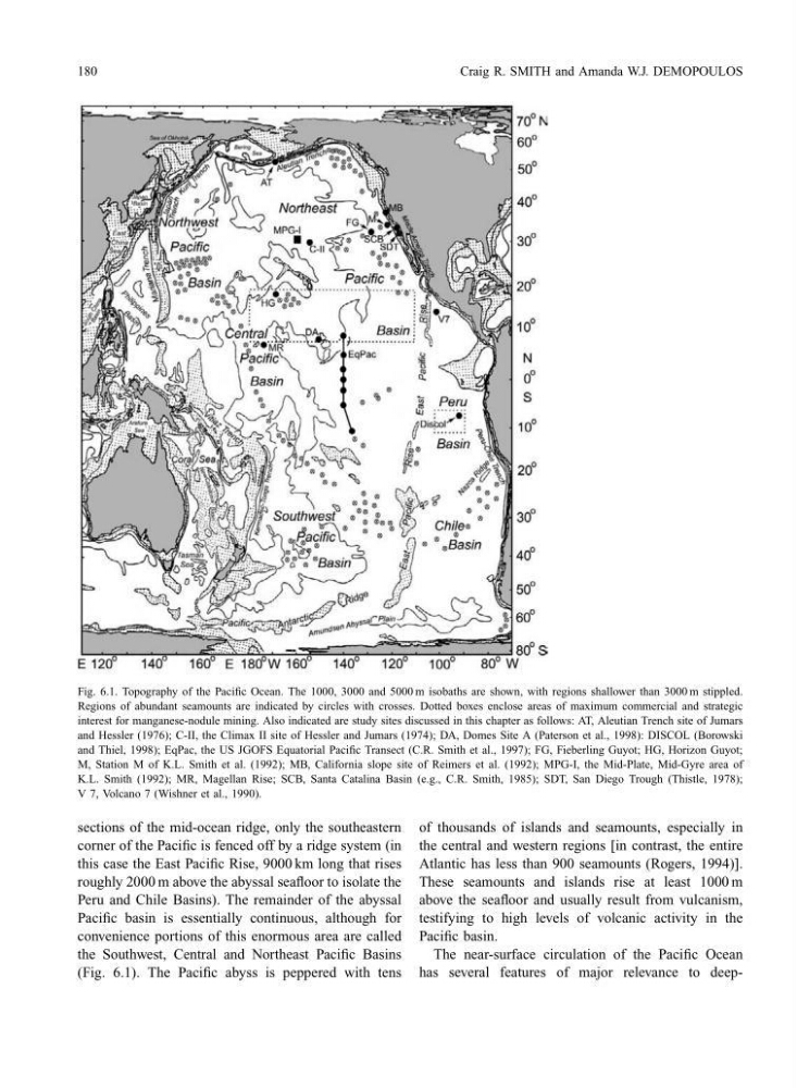
Fig. 6.1. Topography of the Pacific Ocean. The 1000, 3000 and 5000 m isobaths are shown, with regions shallower than 3000 m stippled.
Regions of abundant seamounts are indicated by circles with crosses. Dotted boxes enclose areas of maximum commercial and strategic
interest for manganese-nodule mining. Also indicated are study sites discussed in this chapter as follows: AT, Aleutian Trench site of Jumars
and Hessler (1976); C-II, the Climax II site of Hessler and Jumars (1974); DA, Domes Site A (Paterson et al., 1998): DISCOL (Borowski
and Thiel, 1998); EqPac, the US JGOFS Equatorial Pacific Transect (C.R. Smith et al., 1997); FG, Fieberling Guyot; HG, Horizon Guyot;
M, Station M of K.L. Smith et al. (1992); MB, California slope site of Reimers et al. (1992); MPG-I, the Mid-Plate, Mid-Gyre area of
K.L. Smith (1992); MR, Magellan Rise; SCB, Santa Catalina Basin (e.g., C.R. Smith, 1985); SDT, San Diego Trough (Thistle, 1978);
V 7, Volcano 7 (Wishner et al., 1990).
sections of the mid-ocean ridge, only the southeastern
corner of the Pacific is fenced off by a ridge system (in
this case the East Pacific Rise, 9000 km long that rises
roughly 2000 m above the abyssal seafloor to isolate the
Peru and Chile Basins). The remainder of the abyssal
Pacific basin is essentially continuous, although for
convenience portions of this enormous area are called
the Southwest, Central and Northeast Pacific Basins
(Fig. 6.1). The Pacific abyss is peppered with tens
of thousands of islands and seamounts, especially in
the central and western regions [in contrast, the entire
Atlantic has less than 900 seamounts (Rogers, 1994)].
These seamounts and islands rise at least 1000 m
above the seafloor and usually result from vulcanism,
testifying to high levels of volcanic activity in the
Pacific basin.
The near-surface circulation of the Pacific Ocean
has several features of major relevance to deep-
Craig R. SMITH and Amanda W.J. DEMOPOULOS
Fig. 6.1. Topography of the Pacific Ocean. The 1000, 3000 and 5000 m isobaths are shown, with regions shallower than 3000 m stippled.
Regions of abundant seamounts are indicated by circles with crosses. Dotted boxes enclose areas of maximum commercial and strategic
interest for manganese-nodule mining. Also indicated are study sites discussed in this chapter as follows: AT, Aleutian Trench site of Jumars
and Hessler (1976); C-II, the Climax II site of Hessler and Jumars (1974); DA, Domes Site A (Paterson et al., 1998): DISCOL (Borowski
and Thiel, 1998); EqPac, the US JGOFS Equatorial Pacific Transect (C.R. Smith et al., 1997); FG, Fieberling Guyot; HG, Horizon Guyot;
M, Station M of K.L. Smith et al. (1992); MB, California slope site of Reimers et al. (1992); MPG-I, the Mid-Plate, Mid-Gyre area of
K.L. Smith (1992); MR, Magellan Rise; SCB, Santa Catalina Basin (e.g., C.R. Smith, 1985); SDT, San Diego Trough (Thistle, 1978);
V 7, Volcano 7 (Wishner et al., 1990).
sections of the mid-ocean ridge, only the southeastern
corner of the Pacific is fenced off by a ridge system (in
this case the East Pacific Rise, 9000 km long that rises
roughly 2000 m above the abyssal seafloor to isolate the
Peru and Chile Basins). The remainder of the abyssal
Pacific basin is essentially continuous, although for
convenience portions of this enormous area are called
the Southwest, Central and Northeast Pacific Basins
(Fig. 6.1). The Pacific abyss is peppered with tens
of thousands of islands and seamounts, especially in
the central and western regions [in contrast, the entire
Atlantic has less than 900 seamounts (Rogers, 1994)].
These seamounts and islands rise at least 1000 m
above the seafloor and usually result from vulcanism,
testifying to high levels of volcanic activity in the
Pacific basin.
The near-surface circulation of the Pacific Ocean
has several features of major relevance to deep-