

Climate change in arid and tropical humid regions
645
1000
.
.
.
.
~I
I
I
I
I
I
9
~
tO
r
I~
I
I
I
I
~ 800
g
o
600
I
"o
"~,
400
~ 2oo
l
l,
l
l
l
l
o
0
10
20
30
40
50
60
Mean annual precipitation (inches)
70
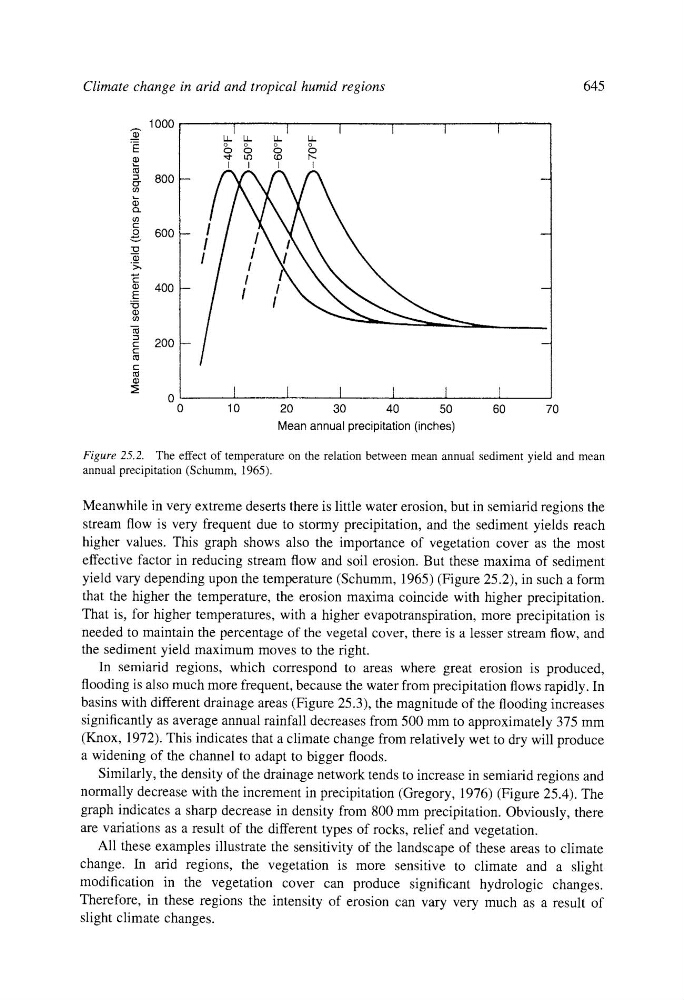
Figure 25.2. The effect of temperature on the relation between mean annual sediment yield and mean
annual precipitation (Schumm, 1965).
Meanwhile in very extreme deserts there is little water erosion, but in semiarid regions the
stream flow is very frequent due to stormy precipitation, and the sediment yields reach
higher values. This graph shows also the importance of vegetation cover as the most
effective factor in reducing stream flow and soil erosion. But these maxima of sediment
yield vary depending upon the temperature (Schumm, 1965) (Figure 25.2), in such a form
that the higher the temperature, the erosion maxima coincide with higher precipitation.
That is, for higher temperatures, with a higher evapotranspiration, more precipitation is
needed to maintain the percentage of the vegetal cover, there is a lesser stream flow, and
the sediment yield maximum moves to the right.
In semiarid regions, which correspond to areas where great erosion is produced,
flooding is also much more frequent, because the water from precipitation flows rapidly. In
basins with different drainage areas (Figure 25.3), the magnitude of the flooding increases
significantly as average annual rainfall decreases from 500 mm to approximately 375 mm
(Knox, 1972). This indicates that a climate change from relatively wet to dry will produce
a widening of the channel to adapt to bigger floods.
Similarly, the density of the drainage network tends to increase in semiarid regions and
normally decrease with the increment in precipitation (Gregory, 1976) (Figure 25.4). The
graph indicates a sharp decrease in density from 800 mm precipitation. Obviously, there
are variations as a result of the different types of rocks, relief and vegetation.
All these examples illustrate the sensitivity of the landscape of these areas to climate
change. In arid regions, the vegetation is more sensitive to climate and a slight
modification in the vegetation cover can produce significant hydrologic changes.
Therefore, in these regions the intensity of erosion can vary very much as a result of
slight climate changes.