

644
Climatic Geomorphology
interpluvial periods can be recognized for deserts by a collection of indirect data of diverse
nature: geomorphologic, archaeologic, pedologic, palinologic, hydrologic, and hydrogeologic (Tricart, 1969, 1979; Thomas, 1977c; Demangeot, 1981; Goudie, 1992).
1.1. Fluvial systems
Although precipitation is scarce in arid environments, stream flow paradoxically plays an
important role in the construction of the landforms of these areas. This is due to the lack of
vegetation cover and to the shortage of soils, so that the geological substrate is unprotected
and exposed to rain drops. Precipitation, although scarce, is frequently very intense and
with an irregular temporal distribution. Thus, in Saharan semiarid areas there is a flooding
per year in average terms, but in more arid regions up to 10 years can happen without any
water circulation in the ouads.
Many authors have dealt with the influence of climate change on the modification of the
geomorphic processes in fluvial systems. In Schumm (1977) and Knox (1984) the direct
and indirect effects of climate on these systems are presented in detail. In arid regions
where vegetal cover is scarce, the variations of the vegetation, as a result of climate
change, can produce significant modifications to the hydrology. Knox (1984) established a
critical threshold in the vegetation cover that can be of 70 %, corresponding to an annual
average precipitation of 400 to 500 mm. For values lower than 70 %, the quantity of soil
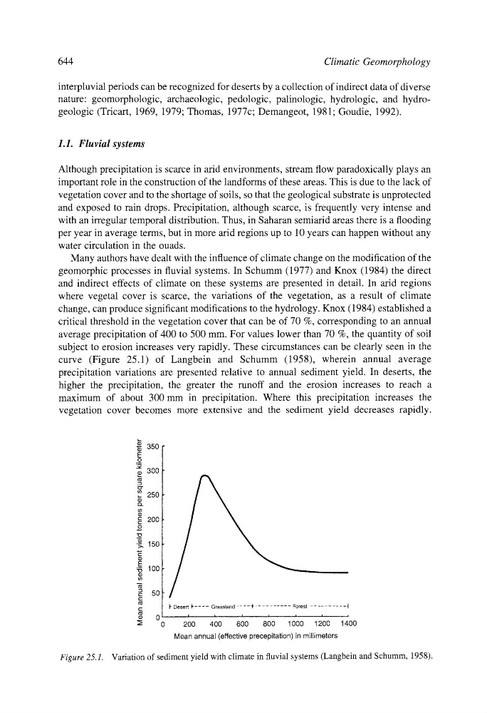
subject to erosion increases very rapidly. These circumstances can be clearly seen in the
curve (Figure 25.1) of Langbein and Schumm (1958), wherein annual average
precipitation variations are presented relative to annual sediment yield. In deserts, the
higher the precipitation, the greater the runoff and the erosion increases to reach a
maximum of about 300 mm in precipitation. Where this precipitation increases the
vegetation cover becomes more extensive and the sediment yield decreases rapidly.
350
E
0
m .m
~ 300
,_ 250
t~
" 200
t9 ~, 15o
t-"
tl)
E
~5 100
m
=
50
c
t" Desert
t" ....
Grassland
....
k ..........
Forest
...........
r
0
i
A
J
,
9
,
= ,
0
200
400
600
800
1000
1200
14
Mean annual (effective precepitation) in millimeters
400
Figure 25.1. Variation of sediment yield with climate in fluvial systems (Langbein and Schumm, 1958).