

Résumé
184
selected area. The difference appears on the samples taken before and after radiometric
enhancement of the same image.
2.6.Shoreline extraction and error evaluation
A dozen reference lines that can be assimilated to the coastline have been defined by Robin
(2002). Some authors take the coastline as the limit of dune vegetation, the most appropriate
indicator to observe and quantify shoreline mobility (Thieler et al. 1994, Robin 2002).
Etymologically, the coastline is the line of the highest spring tides and thus delimits the Public
Maritime Domain. On microtidal coasts where the tidal range is negligible, the coastline is
often associated with the instantaneous shoreline (Suanez et al. 1993, Durand 1969), although
the tide induces a margin of error, meteorological conditions (surge/surge) and the
morphological variability of swash zones (fluctuations in their slope). This is why we chose to
define the coastline by the radiometric difference between the dark pixels related to wet areas
and the light pixels (Dolan et al. 1978 , Crowell et al. 1991, Douglas and Crowell 2000 ,
Thieler et al. 1994).
The accuracy of the coastline position and the percentage of extraction error is affected by
two types of uncertainty: positional uncertainty related to the nature of the shoreline position
at the time it was taken, the ortho-rectification process, and the on-screen delineation of the
coastline reference feature, and the positional uncertainty of DGPS (Tab.2).
These uncertainties are considered random and uncorrelated. Finally, the total uncertainty is
given by the square root of the sum of the squares of the different variables (Fletcher et al.
2003).
í µí±í µí±¡ = ± √ í µí±¡ 2 + í µí± í µí±í µí± 2 + í µí± 2 + í µí°·í µí°ºí µí±í µí±í µí± í µí±í µí±²
(eqt 1)
Where :
Ut Total uncertainties
t Tidal stage uncertainty
O On-screen delineation
RMS Ortho-rectification uncertainty
DGPS Error in location
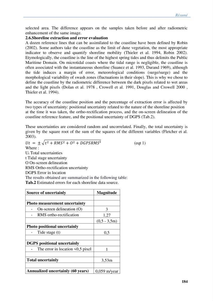
The results obtained are summarized in the following table:
Tab.2 Estimated errors for each shoreline data source.
Source of uncertainly
Magnitude
Photo measurement uncertainty
- On-screen delineation (O)
3
- RMS ortho-rectification
1,27
(0,5 - 3,5m)
Photo positional uncertainly
- Tide stage (t)
0,5
DGPS positional uncertainly
- The error in location <0,5 pixel
1
Total uncertainly
3,53m
Annualized uncertainly (60 years)
0,059 m/year
184
selected area. The difference appears on the samples taken before and after radiometric
enhancement of the same image.
2.6.Shoreline extraction and error evaluation
A dozen reference lines that can be assimilated to the coastline have been defined by Robin
(2002). Some authors take the coastline as the limit of dune vegetation, the most appropriate
indicator to observe and quantify shoreline mobility (Thieler et al. 1994, Robin 2002).
Etymologically, the coastline is the line of the highest spring tides and thus delimits the Public
Maritime Domain. On microtidal coasts where the tidal range is negligible, the coastline is
often associated with the instantaneous shoreline (Suanez et al. 1993, Durand 1969), although
the tide induces a margin of error, meteorological conditions (surge/surge) and the
morphological variability of swash zones (fluctuations in their slope). This is why we chose to
define the coastline by the radiometric difference between the dark pixels related to wet areas
and the light pixels (Dolan et al. 1978 , Crowell et al. 1991, Douglas and Crowell 2000 ,
Thieler et al. 1994).
The accuracy of the coastline position and the percentage of extraction error is affected by
two types of uncertainty: positional uncertainty related to the nature of the shoreline position
at the time it was taken, the ortho-rectification process, and the on-screen delineation of the
coastline reference feature, and the positional uncertainty of DGPS (Tab.2).
These uncertainties are considered random and uncorrelated. Finally, the total uncertainty is
given by the square root of the sum of the squares of the different variables (Fletcher et al.
2003).
í µí±í µí±¡ = ± √ í µí±¡ 2 + í µí± í µí±í µí± 2 + í µí± 2 + í µí°·í µí°ºí µí±í µí±í µí± í µí±í µí±²
(eqt 1)
Where :
Ut Total uncertainties
t Tidal stage uncertainty
O On-screen delineation
RMS Ortho-rectification uncertainty
DGPS Error in location
The results obtained are summarized in the following table:
Tab.2 Estimated errors for each shoreline data source.
Source of uncertainly
Magnitude
Photo measurement uncertainty
- On-screen delineation (O)
3
- RMS ortho-rectification
1,27
(0,5 - 3,5m)
Photo positional uncertainly
- Tide stage (t)
0,5
DGPS positional uncertainly
- The error in location <0,5 pixel
1
Total uncertainly
3,53m
Annualized uncertainly (60 years)
0,059 m/year