

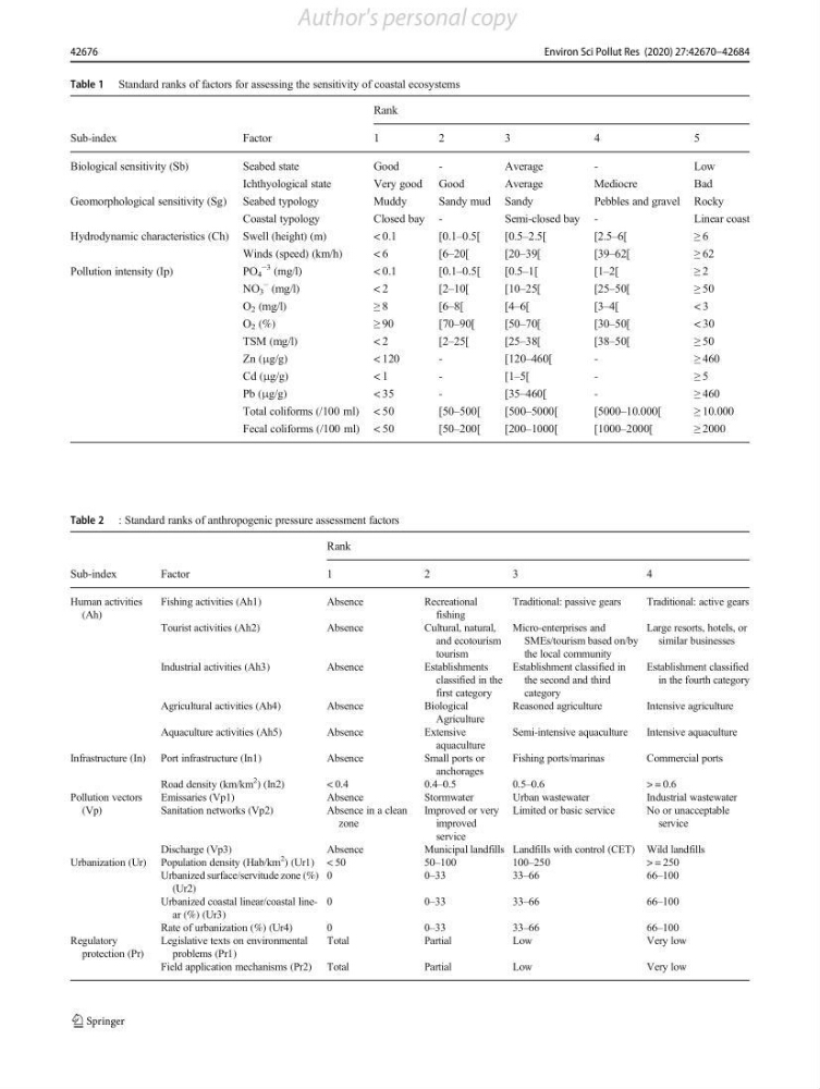
Table 1 Standard ranks of factors for assessing the sensitivity of coastal ecosystems
Rank
Sub-index
Factor
1
2
3
4
5
Biological sensitivity (Sb)
Seabed state
Good
-
Average
-
Low
Ichthyological state
Very good Good
Average
Mediocre
Bad
Geomorphological sensitivity (Sg) Seabed typology
Muddy
Sandy mud Sandy
Pebbles and gravel Rocky
Coastal typology
Closed bay -
Semi-closed bay -
Linear coast
Hydrodynamic characteristics (Ch) Swell (height) (m)
< 0.1
[0.1–0.5[
[0.5–2.5[
[2.5–6[
≥ 6
Winds (speed) (km/h)
< 6
[6–20[
[20–39[
[39–62[
≥ 62
Pollution intensity (Ip)
PO 4
−3 (mg/l)
< 0.1
[0.1–0.5[
[0.5–1[
[1–2[
≥ 2
NO 3
− (mg/l)
< 2
[2–10[
[10–25[
[25–50[
≥ 50
O 2 (mg/l)
≥ 8
[ 6 –8[
[4–6[
[3–4[
< 3
O 2 (%)
≥ 90
[70–90[
[50–70[
[30–50[
< 30
TSM (mg/l)
< 2
[2–25[
[25–38[
[38–50[
≥ 50
Zn (μg/g)
< 120
-
[120–460[
-
≥ 460
Cd (μg/g)
< 1
-
[1–5[
-
≥ 5
Pb (μg/g)
< 35
-
[35–460[
-
≥ 460
Total coliforms (/100 ml) < 50
[50–500[
[500–5000[
[5000–10.000[
≥ 10.000
Fecal coliforms (/100 ml) < 50
[50–200[
[200–1000[
[1000–2000[
≥ 2000
Table 2 : Standard ranks of anthropogenic pressure assessment factors
Rank
Sub-index
Factor
1
2
3
4
Human activities
(Ah)
Fishing activities (Ah1)
Absence
Recreational
fishing
Traditional: passive gears
Traditional: active gears
Tourist activities (Ah2)
Absence
Cultural, natural,
and ecotourism
tourism
Micro-enterprises and
SMEs/tourism based on/by
the local community
Large resorts, hotels, or
similar businesses
Industrial activities (Ah3)
Absence
Establishments
classified in the
first category
Establishment classified in
the second and third
category
Establishment classified
in the fourth category
Agricultural activities (Ah4)
Absence
Biological
Agriculture
Reasoned agriculture
Intensive agriculture
Aquaculture activities (Ah5)
Absence
Extensive
aquaculture
Semi-intensive aquaculture
Intensive aquaculture
Infrastructure (In) Port infrastructure (In1)
Absence
Small ports or
anchorages
Fishing ports/marinas
Commercial ports
Road density (km/km
2
) (In2)
< 0.4
0.4–0.5
0.5–0.6
> = 0.6
Pollution vectors
(Vp)
Emissaries (Vp1)
Absence
Stormwater
Urban wastewater
Industrial wastewater
Sanitation networks (Vp2)
Absence in a clean
zone
Improved or very
improved
service
Limited or basic service
No or unacceptable
service
Discharge (Vp3)
Absence
Municipal landfills Landfills with control (CET) Wild landfills
Urbanization (Ur) Population density (Hab/km
2
) (Ur1) < 50
50–100
100–250
> = 250
Urbanized surface/servitude zone (%)
(Ur2)
0
0 –33
33–66
66–100
Urbanized coastal linear/coastal linear (%) (Ur3)
0
0 –33
33–66
66–100
Rate of urbanization (%) (Ur4)
0
0–33
33–66
66–100
Regulatory
protection (Pr)
Legislative texts on environmental
problems (Pr1)
Total
Partial
Low
Very low
Field application mechanisms (Pr2) Total
Partial
Low
Very low
42676
Environ Sci Pollut Res (2020) 27:42670–42684
Author's personal copy
Rank
Sub-index
Factor
1
2
3
4
5
Biological sensitivity (Sb)
Seabed state
Good
-
Average
-
Low
Ichthyological state
Very good Good
Average
Mediocre
Bad
Geomorphological sensitivity (Sg) Seabed typology
Muddy
Sandy mud Sandy
Pebbles and gravel Rocky
Coastal typology
Closed bay -
Semi-closed bay -
Linear coast
Hydrodynamic characteristics (Ch) Swell (height) (m)
< 0.1
[0.1–0.5[
[0.5–2.5[
[2.5–6[
≥ 6
Winds (speed) (km/h)
< 6
[6–20[
[20–39[
[39–62[
≥ 62
Pollution intensity (Ip)
PO 4
−3 (mg/l)
< 0.1
[0.1–0.5[
[0.5–1[
[1–2[
≥ 2
NO 3
− (mg/l)
< 2
[2–10[
[10–25[
[25–50[
≥ 50
O 2 (mg/l)
≥ 8
[ 6 –8[
[4–6[
[3–4[
< 3
O 2 (%)
≥ 90
[70–90[
[50–70[
[30–50[
< 30
TSM (mg/l)
< 2
[2–25[
[25–38[
[38–50[
≥ 50
Zn (μg/g)
< 120
-
[120–460[
-
≥ 460
Cd (μg/g)
< 1
-
[1–5[
-
≥ 5
Pb (μg/g)
< 35
-
[35–460[
-
≥ 460
Total coliforms (/100 ml) < 50
[50–500[
[500–5000[
[5000–10.000[
≥ 10.000
Fecal coliforms (/100 ml) < 50
[50–200[
[200–1000[
[1000–2000[
≥ 2000
Table 2 : Standard ranks of anthropogenic pressure assessment factors
Rank
Sub-index
Factor
1
2
3
4
Human activities
(Ah)
Fishing activities (Ah1)
Absence
Recreational
fishing
Traditional: passive gears
Traditional: active gears
Tourist activities (Ah2)
Absence
Cultural, natural,
and ecotourism
tourism
Micro-enterprises and
SMEs/tourism based on/by
the local community
Large resorts, hotels, or
similar businesses
Industrial activities (Ah3)
Absence
Establishments
classified in the
first category
Establishment classified in
the second and third
category
Establishment classified
in the fourth category
Agricultural activities (Ah4)
Absence
Biological
Agriculture
Reasoned agriculture
Intensive agriculture
Aquaculture activities (Ah5)
Absence
Extensive
aquaculture
Semi-intensive aquaculture
Intensive aquaculture
Infrastructure (In) Port infrastructure (In1)
Absence
Small ports or
anchorages
Fishing ports/marinas
Commercial ports
Road density (km/km
2
) (In2)
< 0.4
0.4–0.5
0.5–0.6
> = 0.6
Pollution vectors
(Vp)
Emissaries (Vp1)
Absence
Stormwater
Urban wastewater
Industrial wastewater
Sanitation networks (Vp2)
Absence in a clean
zone
Improved or very
improved
service
Limited or basic service
No or unacceptable
service
Discharge (Vp3)
Absence
Municipal landfills Landfills with control (CET) Wild landfills
Urbanization (Ur) Population density (Hab/km
2
) (Ur1) < 50
50–100
100–250
> = 250
Urbanized surface/servitude zone (%)
(Ur2)
0
0 –33
33–66
66–100
Urbanized coastal linear/coastal linear (%) (Ur3)
0
0 –33
33–66
66–100
Rate of urbanization (%) (Ur4)
0
0–33
33–66
66–100
Regulatory
protection (Pr)
Legislative texts on environmental
problems (Pr1)
Total
Partial
Low
Very low
Field application mechanisms (Pr2) Total
Partial
Low
Very low
42676
Environ Sci Pollut Res (2020) 27:42670–42684
Author's personal copy