

58
Chapter 7
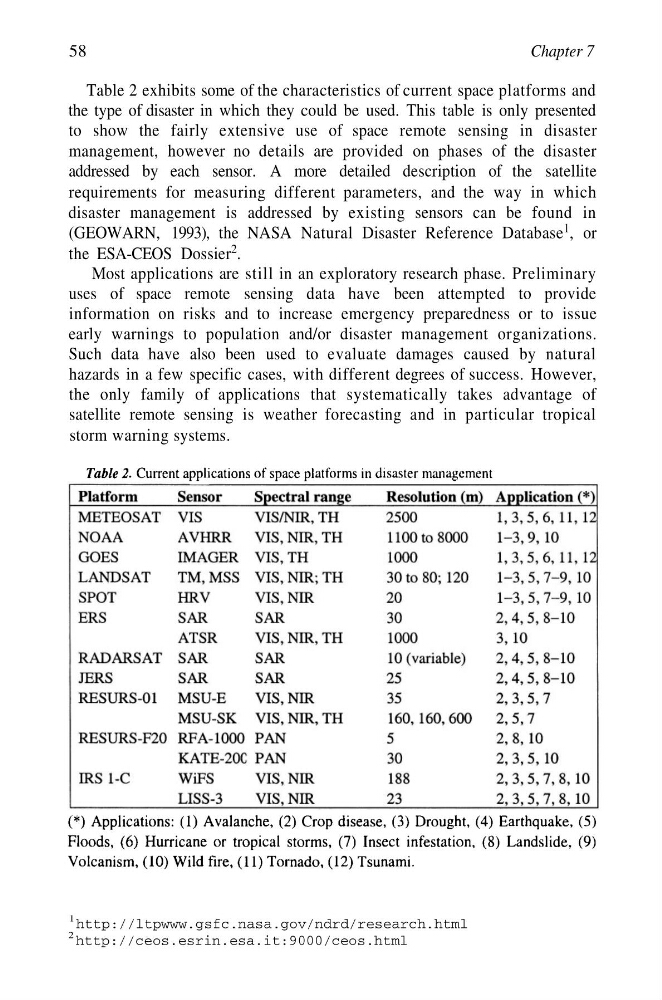
Table 2 exhibits some of the characteristics of current space platforms and
the type of disaster in which they could be used. This table is only presented
to show the fairly extensive use of space remote sensing in disaster
management, however no details are provided on phases of the disaster
addressed by each sensor. A more detailed description of the satellite
requirements for measuring different parameters, and the way in which
disaster management is addressed by existing sensors can be found in
(GEOWARN, 1993), the NASA Natural Disaster Reference Database
1 , or
the ESA-CEOS Dossier
2 .
Most applications are still in an exploratory research phase. Preliminary
uses of space remote sensing data have been attempted to provide
information on risks and to increase emergency preparedness or to issue
early warnings to population and/or disaster management organizations.
Such data have also been used to evaluate damages caused by natural
hazards in a few specific cases, with different degrees of success. However,
the only family of applications that systematically takes advantage of
satellite remote sensing is weather forecasting and in particular tropical
storm warning systems.
1 http://ltpwww.gsfc.nasa.gov/ndrd/research.html
2 http://ceos.esrin.esa.it:9000/ceos.html
Chapter 7
Table 2 exhibits some of the characteristics of current space platforms and
the type of disaster in which they could be used. This table is only presented
to show the fairly extensive use of space remote sensing in disaster
management, however no details are provided on phases of the disaster
addressed by each sensor. A more detailed description of the satellite
requirements for measuring different parameters, and the way in which
disaster management is addressed by existing sensors can be found in
(GEOWARN, 1993), the NASA Natural Disaster Reference Database
1 , or
the ESA-CEOS Dossier
2 .
Most applications are still in an exploratory research phase. Preliminary
uses of space remote sensing data have been attempted to provide
information on risks and to increase emergency preparedness or to issue
early warnings to population and/or disaster management organizations.
Such data have also been used to evaluate damages caused by natural
hazards in a few specific cases, with different degrees of success. However,
the only family of applications that systematically takes advantage of
satellite remote sensing is weather forecasting and in particular tropical
storm warning systems.
1 http://ltpwww.gsfc.nasa.gov/ndrd/research.html
2 http://ceos.esrin.esa.it:9000/ceos.html