

27. ESA’S PLANS AND STRATEGY FOR OPTICAL REMOTE
SENSING OF TERRESTRIAL SURFACES IN THE NEXT DECADE
275
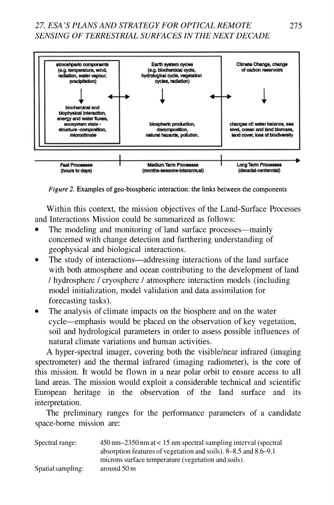
Within this context, the mission objectives of the Land-Surface Processes
and Interactions Mission could be summarized as follows:
The modeling and monitoring of land surface processes—mainly
concerned with change detection and furthering understanding of
geophysical and biological interactions.
The study of interactions—addressing interactions of the land surface
with both atmosphere and ocean contributing to the development of land
/ hydrosphere / cryosphere / atmosphere interaction models (including
model initialization, model validation and data assimilation for
forecasting tasks).
The analysis of climate impacts on the biosphere and on the water
cycle—emphasis would be placed on the observation of key vegetation,
soil and hydrological parameters in order to assess possible influences of
natural climate variations and human activities.
A hyper-spectral imager, covering both the visible/near infrared (imaging
spectrometer) and the thermal infrared (imaging radiometer), is the core of
this mission. It would be flown in a near polar orbit to ensure access to all
land areas. The mission would exploit a considerable technical and scientific
European heritage in the observation of the land surface and its
interpretation.
The preliminary ranges for the performance parameters of a candidate
space-borne mission are:
Spectral range:
Spatial sampling:
450 nm–2350 nm at < 15 nm spectral sampling interval (spectral
absorption features of vegetation and soils). 8–8.5 and 8.6–9.1
microns surface temperature (vegetation and soils).
around 50 m
SENSING OF TERRESTRIAL SURFACES IN THE NEXT DECADE
275
Within this context, the mission objectives of the Land-Surface Processes
and Interactions Mission could be summarized as follows:
The modeling and monitoring of land surface processes—mainly
concerned with change detection and furthering understanding of
geophysical and biological interactions.
The study of interactions—addressing interactions of the land surface
with both atmosphere and ocean contributing to the development of land
/ hydrosphere / cryosphere / atmosphere interaction models (including
model initialization, model validation and data assimilation for
forecasting tasks).
The analysis of climate impacts on the biosphere and on the water
cycle—emphasis would be placed on the observation of key vegetation,
soil and hydrological parameters in order to assess possible influences of
natural climate variations and human activities.
A hyper-spectral imager, covering both the visible/near infrared (imaging
spectrometer) and the thermal infrared (imaging radiometer), is the core of
this mission. It would be flown in a near polar orbit to ensure access to all
land areas. The mission would exploit a considerable technical and scientific
European heritage in the observation of the land surface and its
interpretation.
The preliminary ranges for the performance parameters of a candidate
space-borne mission are:
Spectral range:
Spatial sampling:
450 nm–2350 nm at < 15 nm spectral sampling interval (spectral
absorption features of vegetation and soils). 8–8.5 and 8.6–9.1
microns surface temperature (vegetation and soils).
around 50 m