

3.4 OBSTACLES TO SUCCESSUL MAPPING OF CORAL REEFS
In the past, some believed that remote sensing of coral reefs was being oversold
(Green et al., 1996). It is evident today, however, that aerial and digital mapping tools
may offer some of the most important data sources for support of management
strategies. Prior to mapping a coastal shoreline inhabited by reefs, researchers must
understand the limitations of remote sensing techniques. The limitations of remote
sensing can be grouped into three categories: (1) fundamental limitations;
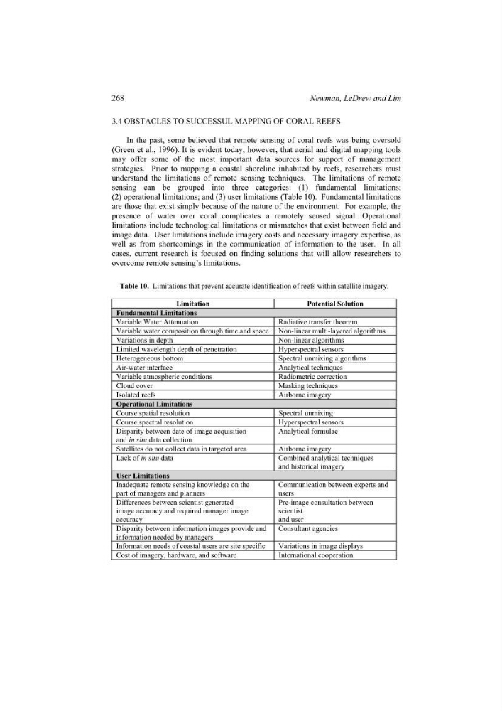
(2) operational limitations; and (3) user limitations (Table 10). Fundamental limitations
are those that exist simply because of the nature of the environment. For example, the
presence of water over coral complicates a remotely sensed signal. Operational
limitations include technological limitations or mismatches that exist between field and
image data. User limitations include imagery costs and necessary imagery expertise, as
well as from shortcomings in the communication of information to the user. In all
cases, current research is focused on finding solutions that will allow researchers to
overcome remote sensing’s limitations.
Table 10. Limitations that prevent accurate identification of reefs within satellite imagery.
Limitation
Potential Solution
Fundamental Limitations
Variable Water Attenuation
Radiative transfer theorem
Variable water composition through time and space Non-linear multi-layered algorithms
Variations in depth
Non-linear algorithms
Limited wavelength depth of penetration
Hyperspectral sensors
Heterogeneous bottom
Spectral unmixing algorithms
Air-water interface
Analytical techniques
Variable atmospheric conditions
Radiometric correction
Cloud cover
Masking techniques
Isolated reefs
Airborne imagery
Operational Limitations
Course spatial resolution
Spectral unmixing
Course spectral resolution
Hyperspectral sensors
Disparity between date of image acquisition
and in situ data collection
Analytical formulae
Satellites do not collect data in targeted area
Airborne imagery
Lack of in situ data
Combined analytical techniques
and historical imagery
User Limitations
Inadequate remote sensing knowledge on the
part of managers and planners
Communication between experts and
users
Differences between scientist generated
image accuracy and required manager image
accuracy
Pre-image consultation between
scientist
and user
Disparity between information images provide and
information needed by managers
Consultant agencies
Information needs of coastal users are site specific
Variations in image displays
Cost of imagery, hardware, and software
International cooperation
268
Newman, LeDrew and Lim
In the past, some believed that remote sensing of coral reefs was being oversold
(Green et al., 1996). It is evident today, however, that aerial and digital mapping tools
may offer some of the most important data sources for support of management
strategies. Prior to mapping a coastal shoreline inhabited by reefs, researchers must
understand the limitations of remote sensing techniques. The limitations of remote
sensing can be grouped into three categories: (1) fundamental limitations;
(2) operational limitations; and (3) user limitations (Table 10). Fundamental limitations
are those that exist simply because of the nature of the environment. For example, the
presence of water over coral complicates a remotely sensed signal. Operational
limitations include technological limitations or mismatches that exist between field and
image data. User limitations include imagery costs and necessary imagery expertise, as
well as from shortcomings in the communication of information to the user. In all
cases, current research is focused on finding solutions that will allow researchers to
overcome remote sensing’s limitations.
Table 10. Limitations that prevent accurate identification of reefs within satellite imagery.
Limitation
Potential Solution
Fundamental Limitations
Variable Water Attenuation
Radiative transfer theorem
Variable water composition through time and space Non-linear multi-layered algorithms
Variations in depth
Non-linear algorithms
Limited wavelength depth of penetration
Hyperspectral sensors
Heterogeneous bottom
Spectral unmixing algorithms
Air-water interface
Analytical techniques
Variable atmospheric conditions
Radiometric correction
Cloud cover
Masking techniques
Isolated reefs
Airborne imagery
Operational Limitations
Course spatial resolution
Spectral unmixing
Course spectral resolution
Hyperspectral sensors
Disparity between date of image acquisition
and in situ data collection
Analytical formulae
Satellites do not collect data in targeted area
Airborne imagery
Lack of in situ data
Combined analytical techniques
and historical imagery
User Limitations
Inadequate remote sensing knowledge on the
part of managers and planners
Communication between experts and
users
Differences between scientist generated
image accuracy and required manager image
accuracy
Pre-image consultation between
scientist
and user
Disparity between information images provide and
information needed by managers
Consultant agencies
Information needs of coastal users are site specific
Variations in image displays
Cost of imagery, hardware, and software
International cooperation
268
Newman, LeDrew and Lim