

232
Phinn, Joyce, Scarth and Roelfsema
Resource –
Personnel
Trained in image classification
Experience with Landsat data
Knowledge of area to be mapped
Trained in image classification and
spectral unmixing or matching.
Experience with Hyperspectral data
Knowledge of area to be mapped
Training in softcopy photogrammetry and
image processing.
Extensive knowledge of area to be mapped
Estimated
task
and times
Image pre-processing (1 day)
Image classification to SAV Types (15
days per scene)
Field/Photo verification for a select
number of sample sites: (8 days)
Map output production: (2 days)
Total = 26 days per scene
Note: This estimate is for a 10km x
10km area
Image pre-processing (2 days)
Image analysis using classification,
un-mixing or matching to define
SAV Types: (8 days per area)
Field/Photo verification for a select
number of sample sites: (3 days)
Map output production: (1 days)
Total = 14 days per 10km x 10km
scene
Note: This estimate is for a 20km x 20km
area (10 x 10 photos)
Aerial Photograph Scanning (1 day)
Digital photographs ortho-correction
(5
days)
Photograph interpretation and digitizing
boundaries (25 days)
Build and clean up vegetation type layer
Map output production: (2 days)
Total = 33 days per 20km x 20km scene
Estimated Cost
Note that these are
estimates are
flexible
Data
acquisition:
Image data = $1950
Aerial Photos (10) = $90/frame to
acquire or less to hire from Dept. of
Natural Resources
Ancillary data (topo sheets) = $200
Processing = 28 days of technical
officer @ $150/day = $4200
Total = $7250
Note: This assumes software have been
purchased
Data acquisition:
Image data = $15000
Aerial Photos (10) = $90/frame to
acquire or less to hire from Dept. of
Natural Resources
Ancillary data (topo sheets) = $200
Processing = 14 days of technical
officer @ $150/day = $1700
Total = $16900
Note: This assumes software have been purchased
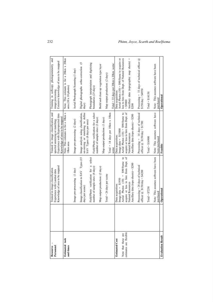
Data acquisition: Aerial Photos (10) = $90/frame to acquire or less to hire from Dept. of Natural Resources = $9000 Ancillary data (topographic map sheets) = $200
Processing = 33 days of technical officer @ $150/day = $4950
Total = $14150
Note: This assumes software have been purchased
Evaluation Result
Operational Feasible Operational
Phinn, Joyce, Scarth and Roelfsema
Resource –
Personnel
Trained in image classification
Experience with Landsat data
Knowledge of area to be mapped
Trained in image classification and
spectral unmixing or matching.
Experience with Hyperspectral data
Knowledge of area to be mapped
Training in softcopy photogrammetry and
image processing.
Extensive knowledge of area to be mapped
Estimated
task
and times
Image pre-processing (1 day)
Image classification to SAV Types (15
days per scene)
Field/Photo verification for a select
number of sample sites: (8 days)
Map output production: (2 days)
Total = 26 days per scene
Note: This estimate is for a 10km x
10km area
Image pre-processing (2 days)
Image analysis using classification,
un-mixing or matching to define
SAV Types: (8 days per area)
Field/Photo verification for a select
number of sample sites: (3 days)
Map output production: (1 days)
Total = 14 days per 10km x 10km
scene
Note: This estimate is for a 20km x 20km
area (10 x 10 photos)
Aerial Photograph Scanning (1 day)
Digital photographs ortho-correction
(5
days)
Photograph interpretation and digitizing
boundaries (25 days)
Build and clean up vegetation type layer
Map output production: (2 days)
Total = 33 days per 20km x 20km scene
Estimated Cost
Note that these are
estimates are
flexible
Data
acquisition:
Image data = $1950
Aerial Photos (10) = $90/frame to
acquire or less to hire from Dept. of
Natural Resources
Ancillary data (topo sheets) = $200
Processing = 28 days of technical
officer @ $150/day = $4200
Total = $7250
Note: This assumes software have been
purchased
Data acquisition:
Image data = $15000
Aerial Photos (10) = $90/frame to
acquire or less to hire from Dept. of
Natural Resources
Ancillary data (topo sheets) = $200
Processing = 14 days of technical
officer @ $150/day = $1700
Total = $16900
Note: This assumes software have been purchased
Data acquisition: Aerial Photos (10) = $90/frame to acquire or less to hire from Dept. of Natural Resources = $9000 Ancillary data (topographic map sheets) = $200
Processing = 33 days of technical officer @ $150/day = $4950
Total = $14150
Note: This assumes software have been purchased
Evaluation Result
Operational Feasible Operational