

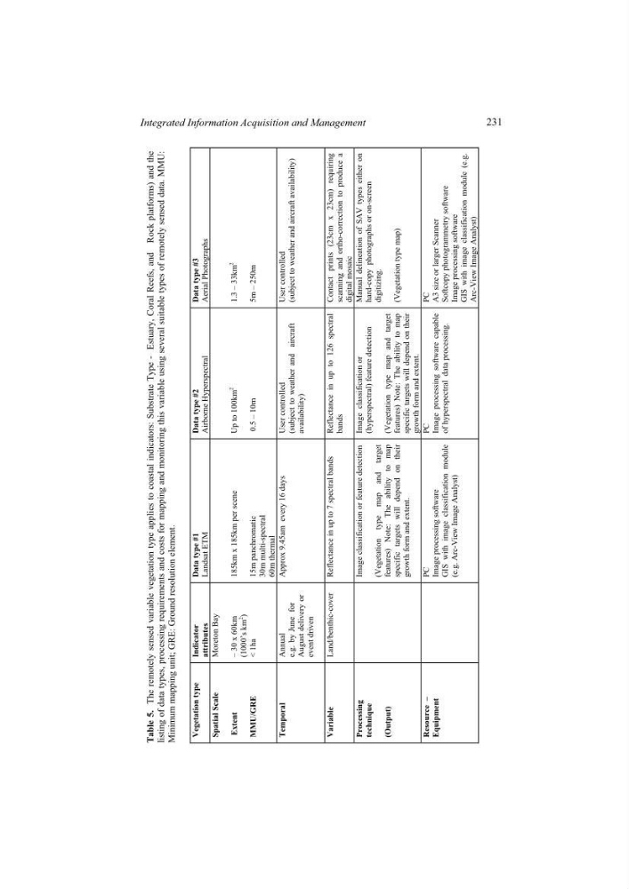
Table 5.
The remotely sensed variable vegetation type
applies to coastal indicators:
Substrate Type - Estuary, Coral Reefs, and Rock
platforms) and the
listing of data types, processing requirements and costs for mapping and monitoring this variable using several suitable types
of remotely sensed data. MMU:
Minimum mapping unit; GRE: Ground resolution element
Vegetation type Indicator attributes
Data type #1
Landsat ETM
Data type #2
Airborne Hyperspectral
Data type #3
Aerial Photographs
Spatial Scale
Extent
MMU/GRE
Moreton Bay
– 30 x 60km
(1000’s km
2
)
< 1ha
185km x 185km per scene
15m panchromatic
30m multi-spectral
60m thermal
Up to 100km
2
0.5 – 10m
1.3 – 33km
2
5m – 250m
Temporal
Annual
e.g. by June
for
August delivery or
event driven
Approx 9.45am every 16 days User controlled
(subject to weather and aircraft
availability)
User controlled (subject to weather and aircraft availability)
Variable
Land/benthic-cover Reflectance in up to 7
spectral bands Reflectance in
up to 126 spectral
bands
Contact prints (23cm x 23cm) requiring scanning and ortho-correction to produce a digital mosaic
Processing
technique
(Output)
Image classification or feature detection
(Vegetation type map and target
features) Note: The ability to map
specific targets will depend on their
growth form and extent.
Image classification or
(hyperspectral) feature detection
(Vegetation type map and target
features) Note: The ability to map
specific targets will depend on their
growth form and extent.
Manual delineation of SAV types either on hard-copy photographs or on-screen digitizing.
(Vegetation type map)
Resource –
Equipment
PC Image processing software
GIS with image classification module
(e.g. Arc-View Image Analyst)
PC Image processing software capable of hyperspectral data processing.
PC A3 size or larger Scanner Softcopy photogrammetry software Image processing software GIS with image classification module (e.g. Arc-View Image Analyst)
.
231
Integrated Information Acquisition and Management
The remotely sensed variable vegetation type
applies to coastal indicators:
Substrate Type - Estuary, Coral Reefs, and Rock
platforms) and the
listing of data types, processing requirements and costs for mapping and monitoring this variable using several suitable types
of remotely sensed data. MMU:
Minimum mapping unit; GRE: Ground resolution element
Vegetation type Indicator attributes
Data type #1
Landsat ETM
Data type #2
Airborne Hyperspectral
Data type #3
Aerial Photographs
Spatial Scale
Extent
MMU/GRE
Moreton Bay
– 30 x 60km
(1000’s km
2
)
< 1ha
185km x 185km per scene
15m panchromatic
30m multi-spectral
60m thermal
Up to 100km
2
0.5 – 10m
1.3 – 33km
2
5m – 250m
Temporal
Annual
e.g. by June
for
August delivery or
event driven
Approx 9.45am every 16 days User controlled
(subject to weather and aircraft
availability)
User controlled (subject to weather and aircraft availability)
Variable
Land/benthic-cover Reflectance in up to 7
spectral bands Reflectance in
up to 126 spectral
bands
Contact prints (23cm x 23cm) requiring scanning and ortho-correction to produce a digital mosaic
Processing
technique
(Output)
Image classification or feature detection
(Vegetation type map and target
features) Note: The ability to map
specific targets will depend on their
growth form and extent.
Image classification or
(hyperspectral) feature detection
(Vegetation type map and target
features) Note: The ability to map
specific targets will depend on their
growth form and extent.
Manual delineation of SAV types either on hard-copy photographs or on-screen digitizing.
(Vegetation type map)
Resource –
Equipment
PC Image processing software
GIS with image classification module
(e.g. Arc-View Image Analyst)
PC Image processing software capable of hyperspectral data processing.
PC A3 size or larger Scanner Softcopy photogrammetry software Image processing software GIS with image classification module (e.g. Arc-View Image Analyst)
.
231
Integrated Information Acquisition and Management