

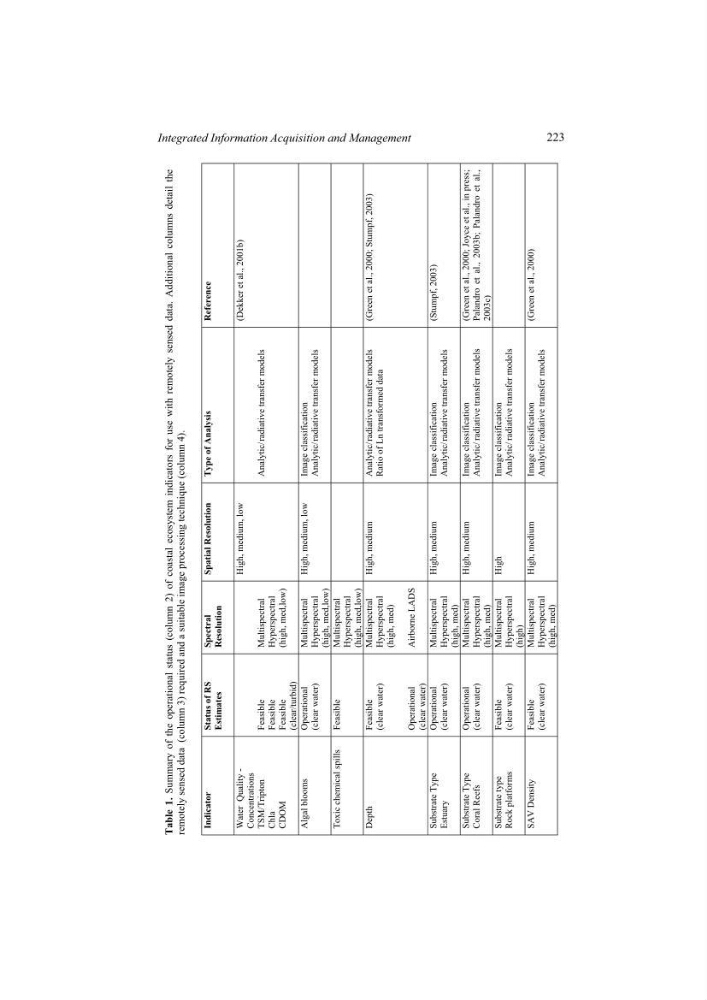
Table 1.
Summary of the operational status (column 2) of coastal ecosystem
indicators for use with remotely sensed data. Additional columns
detail the
remotely sensed data (column 3) required and a suitable image processing
technique (column 4).
Indicator Status of RS
Estimates
Spectral Resolution
Spatial Resolution Type of Analysis
Reference
Water Quality -
Concentrations
TSM/Tripton
Chla CDOM
Feasible Feasible Feasible (clear/turbid)
Multispectral Hyperspectral
(high, med,low)
High, medium, low
Analytic/ radiative transfer models
(Dekker et al., 2001b)
Algal blooms Operational
(clear water)
Multispectral Hyperspectral
(high, med,low)
High, medium, low Image classification
Analytic/ radiative transfer models
Toxic chemical spills Feasible
Multispectral Hyperspectral
(high, med,low)
Depth Feasible
(clear water)
Operational
(clear water)
Multispectral Hyperspectral
(high, med)
Airborne LADS
High, medium Analytic/ radiative transfer models
Ratio of Ln transformed data
(Green et al., 2000; Stumpf, 2003)
Substrate Type
Estuary
Operational
(clear water)
Multispectral Hyperspectral
(high, med)
High, medium Image classification
Analytic/ radiative transfer models
(Stumpf, 2003)
Substrate Type
Coral Reefs
Operational
(clear water)
Multispectral Hyperspectral
(high, med)
High, medium Image classification Analytic/ radiative transfer models
(Green et al., 2000; Joyce et al., in press; Palandro et al., 2003b; Palandro et al., 2003c)
Substrate type
Rock platforms
Feasible
(clear water)
Multispectral Hyperspectral
(high)
High Image
classification Analytic/ radiative transfer models
SAV Density Feasible
(clear water)
Multispectral Hyperspectral
(high, med)
High, medium Image classification Analytic/ radiative transfer models
(Green et al., 2000)
223
Integrated Information Acquisition and Management
Summary of the operational status (column 2) of coastal ecosystem
indicators for use with remotely sensed data. Additional columns
detail the
remotely sensed data (column 3) required and a suitable image processing
technique (column 4).
Indicator Status of RS
Estimates
Spectral Resolution
Spatial Resolution Type of Analysis
Reference
Water Quality -
Concentrations
TSM/Tripton
Chla CDOM
Feasible Feasible Feasible (clear/turbid)
Multispectral Hyperspectral
(high, med,low)
High, medium, low
Analytic/ radiative transfer models
(Dekker et al., 2001b)
Algal blooms Operational
(clear water)
Multispectral Hyperspectral
(high, med,low)
High, medium, low Image classification
Analytic/ radiative transfer models
Toxic chemical spills Feasible
Multispectral Hyperspectral
(high, med,low)
Depth Feasible
(clear water)
Operational
(clear water)
Multispectral Hyperspectral
(high, med)
Airborne LADS
High, medium Analytic/ radiative transfer models
Ratio of Ln transformed data
(Green et al., 2000; Stumpf, 2003)
Substrate Type
Estuary
Operational
(clear water)
Multispectral Hyperspectral
(high, med)
High, medium Image classification
Analytic/ radiative transfer models
(Stumpf, 2003)
Substrate Type
Coral Reefs
Operational
(clear water)
Multispectral Hyperspectral
(high, med)
High, medium Image classification Analytic/ radiative transfer models
(Green et al., 2000; Joyce et al., in press; Palandro et al., 2003b; Palandro et al., 2003c)
Substrate type
Rock platforms
Feasible
(clear water)
Multispectral Hyperspectral
(high)
High Image
classification Analytic/ radiative transfer models
SAV Density Feasible
(clear water)
Multispectral Hyperspectral
(high, med)
High, medium Image classification Analytic/ radiative transfer models
(Green et al., 2000)
223
Integrated Information Acquisition and Management