

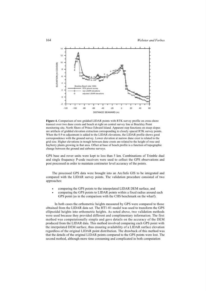
Figure 4. Comparison of raw gridded LIDAR points with RTK survey profile on cross-shore
transect over two dune crests and beach at right on central survey line at Brackley Point
monitoring site, North Shore of Prince Edward Island. Apparent step functions on steep slopes
are artifacts of gridded elevation extraction corresponding to closely spaced RTK survey points.
When the 0.9 m adjustment is added to the LIDAR elevations, the LIDAR profile shows good
correspondence with the ground survey. Lower elevation at narrow dune crest is related to the
grid size. Higher elevations in trough between dune crests are related to the height of rose and
bayberry plants growing in that area. Offset at base of beach profile is a function of topographic
change between the ground and airborne surveys.
GPS base and rover units were kept to less than 5 km. Combinations of Trimble dual
and single frequency P-code receivers were used to collect the GPS observations and
post processed in order to maintain centimeter level accuracy of the points.
The processed GPS data were brought into an Arc/Info GIS to be integrated and
compared with the LIDAR survey points. The validation procedure consisted of two
approaches:
x
comparing the GPS points to the interpolated LIDAR DEM surface, and
x
comparing the GPS points to LIDAR points within a fixed radius around each
GPS point (as in the comparison with the CHS benchmark on the wharf).
second method, although more time consuming and complicated in both computation
method was computationally simple and gave details on the accuracy of the DEM
In both cases the orthometric heights measured by GPS were compared to those
obtained from the LIDAR data set. The HT1-01 model was used to transform the GPS
were used because they provided different and complimentary information. The first
ellipsoidal heights into orthometric heights. As noted above, two validation methods
produced from the LIDAR data. This method involved comparing each GPS point with
the interpolated DEM surface, thus ensuring availability of a LIDAR surface elevation
regardless of the original LIDAR point distribution. The drawback of this method was
that the details of the original LIDAR points compared to the GPS points were lost. The
164
Webster and Forbes
transect over two dune crests and beach at right on central survey line at Brackley Point
monitoring site, North Shore of Prince Edward Island. Apparent step functions on steep slopes
are artifacts of gridded elevation extraction corresponding to closely spaced RTK survey points.
When the 0.9 m adjustment is added to the LIDAR elevations, the LIDAR profile shows good
correspondence with the ground survey. Lower elevation at narrow dune crest is related to the
grid size. Higher elevations in trough between dune crests are related to the height of rose and
bayberry plants growing in that area. Offset at base of beach profile is a function of topographic
change between the ground and airborne surveys.
GPS base and rover units were kept to less than 5 km. Combinations of Trimble dual
and single frequency P-code receivers were used to collect the GPS observations and
post processed in order to maintain centimeter level accuracy of the points.
The processed GPS data were brought into an Arc/Info GIS to be integrated and
compared with the LIDAR survey points. The validation procedure consisted of two
approaches:
x
comparing the GPS points to the interpolated LIDAR DEM surface, and
x
comparing the GPS points to LIDAR points within a fixed radius around each
GPS point (as in the comparison with the CHS benchmark on the wharf).
second method, although more time consuming and complicated in both computation
method was computationally simple and gave details on the accuracy of the DEM
In both cases the orthometric heights measured by GPS were compared to those
obtained from the LIDAR data set. The HT1-01 model was used to transform the GPS
were used because they provided different and complimentary information. The first
ellipsoidal heights into orthometric heights. As noted above, two validation methods
produced from the LIDAR data. This method involved comparing each GPS point with
the interpolated DEM surface, thus ensuring availability of a LIDAR surface elevation
regardless of the original LIDAR point distribution. The drawback of this method was
that the details of the original LIDAR points compared to the GPS points were lost. The
164
Webster and Forbes