

The nominal accuracy of the system used in this study is ±30 cm both horizontally
and in the vertical. The preliminary data output includes geographic coordinates
(longitude and latitude) and elevation (in meters) for each laser point reflection, all
referenced to the World Geodetic System ellipsoid of 1984 (WGS 84), the ellipsoid
employed in the GPS system. If the data are to be used for GIS applications such as
flood risk mapping, the horizontal coordinates are converted to an appropriate map
projection, in this case using the Universal Transverse Mercator (UTM) grid.
Elevations on most land-based topographic maps are measured relative to a geodetic
vertical datum. For Canada this is known as the Canadian Geodetic Vertical Datum of
1928 (CGVD28). Thus, for many applications, including flood risk mapping, the
LIDAR elevations are transformed from ellipsoid heights to orthometric heights.
Orthometric heights are based on the geoid, an equipotential surface defined by the
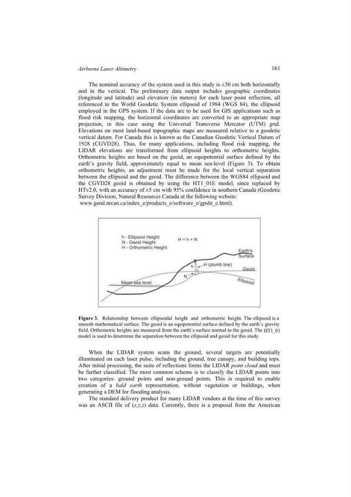
earth’s gravity field, approximately equal to mean sea-level (Figure 3). To obtain
orthometric heights, an adjustment must be made for the local vertical separation
between the ellipsoid and the geoid. The difference between the WGS84 ellipsoid and
the CGVD28 geoid is obtained by using the HT1_01E model, since replaced by
HTv2.0, with an accuracy of ±5 cm with 95% confidence in southern Canada (Geodetic
Survey Division, Natural Resources Canada at the following website:
www.geod.nrcan.ca/index_e/products_e/software_e/gpsht_e.html).
Figure 3. Relationship between ellipsoidal height and orthometric height. The ellipsoid is a
smooth mathematical surface. The geoid is an equipotential surface defined by the earth’s gravity
field. Orthometric heights are measured from the earth’s surface normal to the geoid. The HT1_01
model is used to determine the separation between the ellipsoid and geoid for this study.
When the LIDAR system scans the ground, several targets are potentially
illuminated on each laser pulse, including the ground, tree canopy, and building tops.
After initial processing, the suite of reflections forms the LIDAR point cloud and must
be further classified. The most common scheme is to classify the LIDAR points into
two categories: ground points and non-ground points. This is required to enable
creation of a bald earth representation, without vegetation or buildings, when
generating a DEM for flooding analysis.
The standard delivery product for many LIDAR vendors at the time of this survey
was an ASCII file of (x,y,z) data. Currently, there is a proposal from the American
161
Airborne Laser Altimetry
and in the vertical. The preliminary data output includes geographic coordinates
(longitude and latitude) and elevation (in meters) for each laser point reflection, all
referenced to the World Geodetic System ellipsoid of 1984 (WGS 84), the ellipsoid
employed in the GPS system. If the data are to be used for GIS applications such as
flood risk mapping, the horizontal coordinates are converted to an appropriate map
projection, in this case using the Universal Transverse Mercator (UTM) grid.
Elevations on most land-based topographic maps are measured relative to a geodetic
vertical datum. For Canada this is known as the Canadian Geodetic Vertical Datum of
1928 (CGVD28). Thus, for many applications, including flood risk mapping, the
LIDAR elevations are transformed from ellipsoid heights to orthometric heights.
Orthometric heights are based on the geoid, an equipotential surface defined by the
earth’s gravity field, approximately equal to mean sea-level (Figure 3). To obtain
orthometric heights, an adjustment must be made for the local vertical separation
between the ellipsoid and the geoid. The difference between the WGS84 ellipsoid and
the CGVD28 geoid is obtained by using the HT1_01E model, since replaced by
HTv2.0, with an accuracy of ±5 cm with 95% confidence in southern Canada (Geodetic
Survey Division, Natural Resources Canada at the following website:
www.geod.nrcan.ca/index_e/products_e/software_e/gpsht_e.html).
Figure 3. Relationship between ellipsoidal height and orthometric height. The ellipsoid is a
smooth mathematical surface. The geoid is an equipotential surface defined by the earth’s gravity
field. Orthometric heights are measured from the earth’s surface normal to the geoid. The HT1_01
model is used to determine the separation between the ellipsoid and geoid for this study.
When the LIDAR system scans the ground, several targets are potentially
illuminated on each laser pulse, including the ground, tree canopy, and building tops.
After initial processing, the suite of reflections forms the LIDAR point cloud and must
be further classified. The most common scheme is to classify the LIDAR points into
two categories: ground points and non-ground points. This is required to enable
creation of a bald earth representation, without vegetation or buildings, when
generating a DEM for flooding analysis.
The standard delivery product for many LIDAR vendors at the time of this survey
was an ASCII file of (x,y,z) data. Currently, there is a proposal from the American
161
Airborne Laser Altimetry