

The model has already been applied for reef resource inventories in the Maldives
(Naseer and Hatcher 2004) and to assist in definition of regional-scale baseline
seagrass cover for the broader Caribbean (Wabnitz et al. 2008).
With regards to accuracy, both the scientists and managers who use remote
sensing products need to have confidence that map classifications represent their
true habitats (or benthic cover types and communities) on the ground and that
image-derived environmental variables (e.g., sea surface temperature, chlorophylla) are both accurate and precise compared with values measured from the field. For
example, in order to be able to confidently scale-up reef metabolic rates, Andréfouët and Payri (2000) needed to trust that the satellite derived habitats represented a reasonable approximation of their true coverage and that the classification
system was able to discriminate effectively between habitats with highly varied
metabolic rates. User confidence in remote sensing methods and products can be
built by showing consistent strong correlation between field measurements and
image maps of the same measurements from multiple sites around the world. For
instance, operational products such as the coral bleaching HotSpot and coral
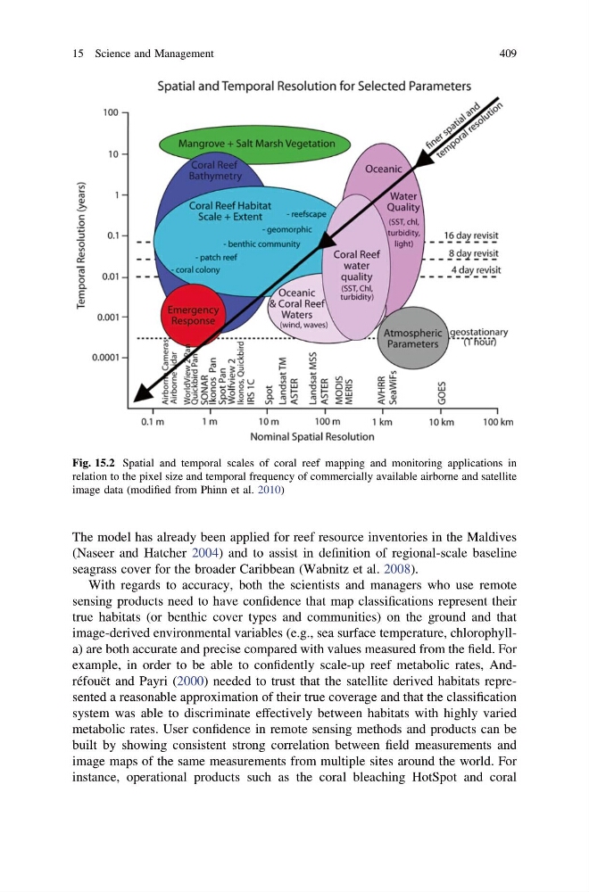
Fig. 15.2 Spatial and temporal scales of coral reef mapping and monitoring applications in
relation to the pixel size and temporal frequency of commercially available airborne and satellite
image data (modified from Phinn et al. 2010)
15 Science and Management
409
(Naseer and Hatcher 2004) and to assist in definition of regional-scale baseline
seagrass cover for the broader Caribbean (Wabnitz et al. 2008).
With regards to accuracy, both the scientists and managers who use remote
sensing products need to have confidence that map classifications represent their
true habitats (or benthic cover types and communities) on the ground and that
image-derived environmental variables (e.g., sea surface temperature, chlorophylla) are both accurate and precise compared with values measured from the field. For
example, in order to be able to confidently scale-up reef metabolic rates, Andréfouët and Payri (2000) needed to trust that the satellite derived habitats represented a reasonable approximation of their true coverage and that the classification
system was able to discriminate effectively between habitats with highly varied
metabolic rates. User confidence in remote sensing methods and products can be
built by showing consistent strong correlation between field measurements and
image maps of the same measurements from multiple sites around the world. For
instance, operational products such as the coral bleaching HotSpot and coral
Fig. 15.2 Spatial and temporal scales of coral reef mapping and monitoring applications in
relation to the pixel size and temporal frequency of commercially available airborne and satellite
image data (modified from Phinn et al. 2010)
15 Science and Management
409