

coral reef remote sensing in new directions, Andréfouët (2008) challenges reef
map producers to additionally create products that address the main needs of reef
map users: (1) comprehensiveness; (2) accuracy; (3) repeatability; and (4) cost
effectiveness.
With respect to comprehensiveness, map classification systems need to be broad
enough to cover all representative habitats in a given region if they are to be used
effectively for spatially explicit research and management applications, such as
community structure analysis, productivity assessments and protected area design.
As a model for this approach, a hierarchical classification scheme was developed
for the global Millennium Coral Reef Mapping Project (imars.usf.edu/MC/),
including more than 800 different geomorphological units that can be extracted
from Landsat 7 Enhanced Thematic Mapper imagery (Andréfouët et al. 2006).
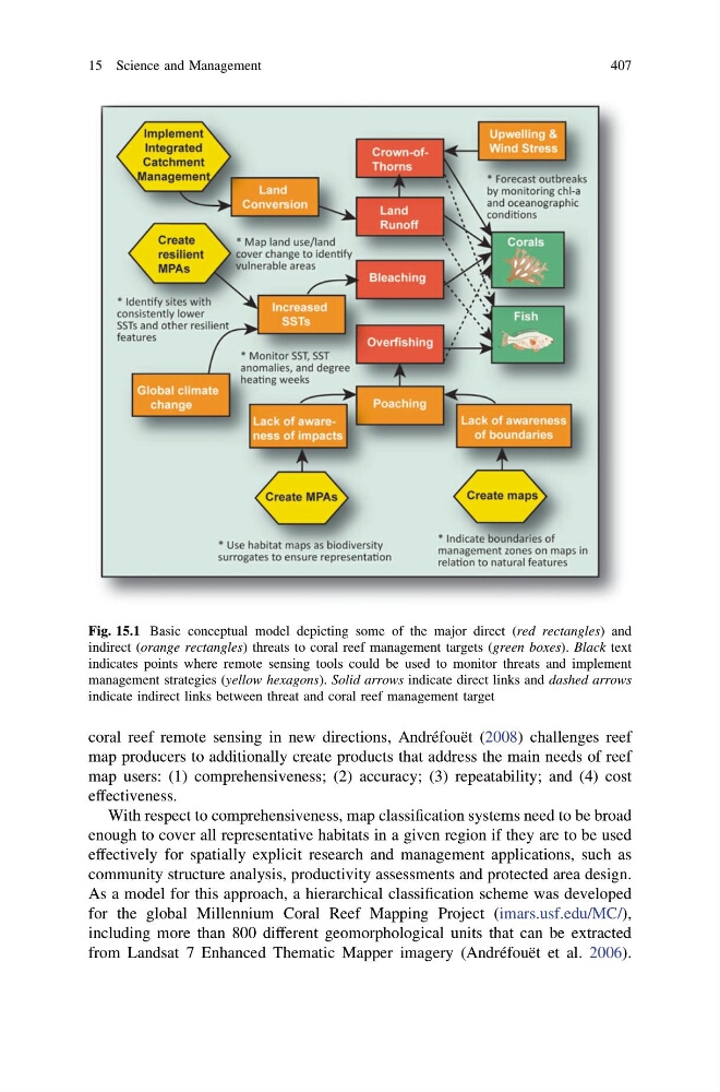
Fig. 15.1 Basic conceptual model depicting some of the major direct (red rectangles) and
indirect (orange rectangles) threats to coral reef management targets (green boxes). Black text
indicates points where remote sensing tools could be used to monitor threats and implement
management strategies (yellow hexagons). Solid arrows indicate direct links and dashed arrows
indicate indirect links between threat and coral reef management target
15 Science and Management
407
map producers to additionally create products that address the main needs of reef
map users: (1) comprehensiveness; (2) accuracy; (3) repeatability; and (4) cost
effectiveness.
With respect to comprehensiveness, map classification systems need to be broad
enough to cover all representative habitats in a given region if they are to be used
effectively for spatially explicit research and management applications, such as
community structure analysis, productivity assessments and protected area design.
As a model for this approach, a hierarchical classification scheme was developed
for the global Millennium Coral Reef Mapping Project (imars.usf.edu/MC/),
including more than 800 different geomorphological units that can be extracted
from Landsat 7 Enhanced Thematic Mapper imagery (Andréfouët et al. 2006).
Fig. 15.1 Basic conceptual model depicting some of the major direct (red rectangles) and
indirect (orange rectangles) threats to coral reef management targets (green boxes). Black text
indicates points where remote sensing tools could be used to monitor threats and implement
management strategies (yellow hexagons). Solid arrows indicate direct links and dashed arrows
indicate indirect links between threat and coral reef management target
15 Science and Management
407