

13.3.2 Example Application
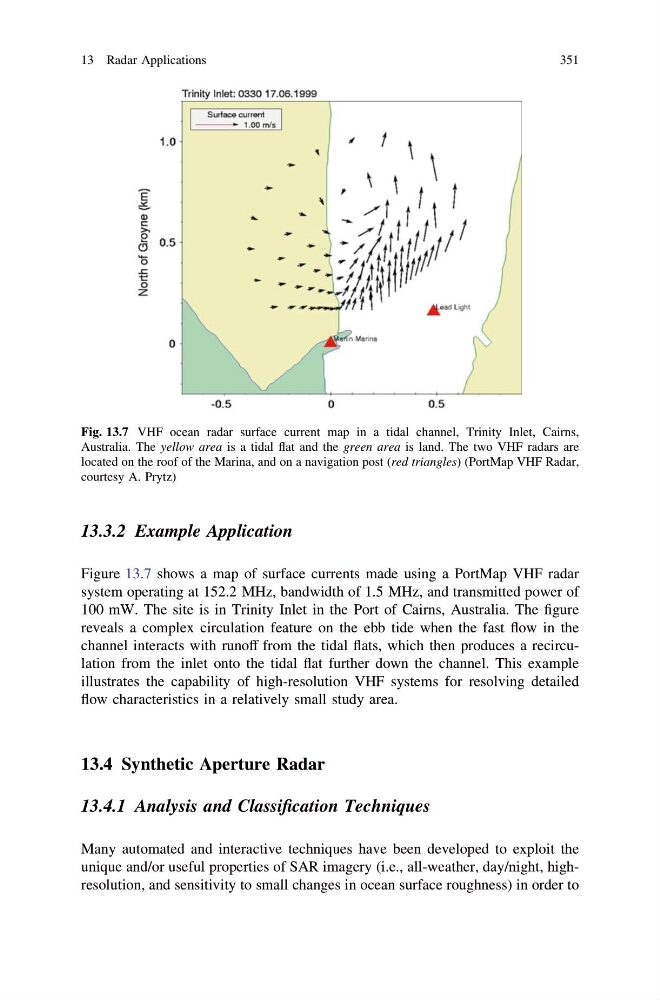
Figure 13.7 shows a map of surface currents made using a PortMap VHF radar
system operating at 152.2 MHz, bandwidth of 1.5 MHz, and transmitted power of
100 mW. The site is in Trinity Inlet in the Port of Cairns, Australia. The figure
reveals a complex circulation feature on the ebb tide when the fast flow in the
channel interacts with runoff from the tidal flats, which then produces a recirculation from the inlet onto the tidal flat further down the channel. This example
illustrates the capability of high-resolution VHF systems for resolving detailed
flow characteristics in a relatively small study area.
13.4 Synthetic Aperture Radar
13.4.1 Analysis and Classification Techniques
Many automated and interactive techniques have been developed to exploit the
unique and/or useful properties of SAR imagery (i.e., all-weather, day/night, highresolution, and sensitivity to small changes in ocean surface roughness) in order to
Fig. 13.7 VHF ocean radar surface current map in a tidal channel, Trinity Inlet, Cairns,
Australia. The yellow area is a tidal flat and the green area is land. The two VHF radars are
located on the roof of the Marina, and on a navigation post (red triangles) (PortMap VHF Radar,
courtesy A. Prytz)
13 Radar Applications
351
Figure 13.7 shows a map of surface currents made using a PortMap VHF radar
system operating at 152.2 MHz, bandwidth of 1.5 MHz, and transmitted power of
100 mW. The site is in Trinity Inlet in the Port of Cairns, Australia. The figure
reveals a complex circulation feature on the ebb tide when the fast flow in the
channel interacts with runoff from the tidal flats, which then produces a recirculation from the inlet onto the tidal flat further down the channel. This example
illustrates the capability of high-resolution VHF systems for resolving detailed
flow characteristics in a relatively small study area.
13.4 Synthetic Aperture Radar
13.4.1 Analysis and Classification Techniques
Many automated and interactive techniques have been developed to exploit the
unique and/or useful properties of SAR imagery (i.e., all-weather, day/night, highresolution, and sensitivity to small changes in ocean surface roughness) in order to
Fig. 13.7 VHF ocean radar surface current map in a tidal channel, Trinity Inlet, Cairns,
Australia. The yellow area is a tidal flat and the green area is land. The two VHF radars are
located on the roof of the Marina, and on a navigation post (red triangles) (PortMap VHF Radar,
courtesy A. Prytz)
13 Radar Applications
351