

9.2.2 Multi-Beam Echo Sounder Application
High-resolution MBES bathymetric imagery is ideal for delineating the complex
geomorphological structures of coral reef habitats, given that it is synoptic, highly
resolved and positionally accurate. The correlation of acoustic signatures with
specific coral reef habitat types, however, is difficult because the magnitude of the
acoustic return varies widely within habitat types, and overlaps across different
habitat types. In order to address this problem, new classification techniques are
being developed to better mine and extract information on the geomorphological
and biological attributes of the seafloor from these highly variable datasets. One of
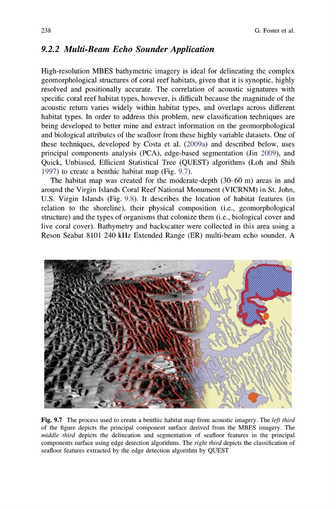
these techniques, developed by Costa et al. (2009a) and described below, uses
principal components analysis (PCA), edge-based segmentation (Jin 2009), and
Quick, Unbiased, Efficient Statistical Tree (QUEST) algorithms (Loh and Shih
1997) to create a benthic habitat map (Fig. 9.7).
The habitat map was created for the moderate-depth (30–60 m) areas in and
around the Virgin Islands Coral Reef National Monument (VICRNM) in St. John,
U.S. Virgin Islands (Fig. 9.8). It describes the location of habitat features (in
relation to the shoreline), their physical composition (i.e., geomorphological
structure) and the types of organisms that colonize them (i.e., biological cover and
live coral cover). Bathymetry and backscatter were collected in this area using a
Reson Seabat 8101 240 kHz Extended Range (ER) multi-beam echo sounder. A
Fig. 9.7 The process used to create a benthic habitat map from acoustic imagery. The left third
of the figure depicts the principal component surface derived from the MBES imagery. The
middle third depicts the delineation and segmentation of seafloor features in the principal
components surface using edge detection algorithms. The right third depicts the classification of
seafloor features extracted by the edge detection algorithm by QUEST
238
G. Foster et al.
High-resolution MBES bathymetric imagery is ideal for delineating the complex
geomorphological structures of coral reef habitats, given that it is synoptic, highly
resolved and positionally accurate. The correlation of acoustic signatures with
specific coral reef habitat types, however, is difficult because the magnitude of the
acoustic return varies widely within habitat types, and overlaps across different
habitat types. In order to address this problem, new classification techniques are
being developed to better mine and extract information on the geomorphological
and biological attributes of the seafloor from these highly variable datasets. One of
these techniques, developed by Costa et al. (2009a) and described below, uses
principal components analysis (PCA), edge-based segmentation (Jin 2009), and
Quick, Unbiased, Efficient Statistical Tree (QUEST) algorithms (Loh and Shih
1997) to create a benthic habitat map (Fig. 9.7).
The habitat map was created for the moderate-depth (30–60 m) areas in and
around the Virgin Islands Coral Reef National Monument (VICRNM) in St. John,
U.S. Virgin Islands (Fig. 9.8). It describes the location of habitat features (in
relation to the shoreline), their physical composition (i.e., geomorphological
structure) and the types of organisms that colonize them (i.e., biological cover and
live coral cover). Bathymetry and backscatter were collected in this area using a
Reson Seabat 8101 240 kHz Extended Range (ER) multi-beam echo sounder. A
Fig. 9.7 The process used to create a benthic habitat map from acoustic imagery. The left third
of the figure depicts the principal component surface derived from the MBES imagery. The
middle third depicts the delineation and segmentation of seafloor features in the principal
components surface using edge detection algorithms. The right third depicts the classification of
seafloor features extracted by the edge detection algorithm by QUEST
238
G. Foster et al.