

unknown propositions is relatively large compared with the number of known
propositions, the main problem of the Bayesian approach is that the probabilities
of the known propositions become unstable, leading to questionable results (Abidi
and Gonzales 1992). The D-S method was developed in an attempt to overcome
such limitations. Many researchers have explored the application of the D-S
method to multisensor target identification, military command and control, and
land-cover classification (Bogler 1987; Waltz and Buede 1989; Park 2002).
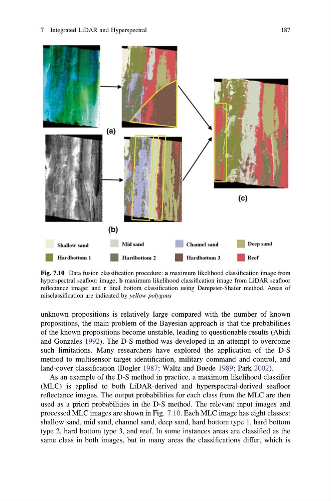
As an example of the D-S method in practice, a maximum likelihood classifier
(MLC) is applied to both LiDAR-derived and hyperspectral-derived seafloor
reflectance images. The output probabilities for each class from the MLC are then
used as a priori probabilities in the D-S method. The relevant input images and
processed MLC images are shown in Fig. 7.10. Each MLC image has eight classes:
shallow sand, mid sand, channel sand, deep sand, hard bottom type 1, hard bottom
type 2, hard bottom type 3, and reef. In some instances areas are classified as the
same class in both images, but in many areas the classifications differ, which is
Fig. 7.10 Data fusion classification procedure: a maximum likelihood classification image from
hyperspectral seafloor image; b maximum likelihood classification image from LiDAR seafloor
reflectance image; and c final bottom classification using Dempster-Shafer method. Areas of
misclassification are indicated by yellow polygons
7 Integrated LiDAR and Hyperspectral
187
propositions, the main problem of the Bayesian approach is that the probabilities
of the known propositions become unstable, leading to questionable results (Abidi
and Gonzales 1992). The D-S method was developed in an attempt to overcome
such limitations. Many researchers have explored the application of the D-S
method to multisensor target identification, military command and control, and
land-cover classification (Bogler 1987; Waltz and Buede 1989; Park 2002).
As an example of the D-S method in practice, a maximum likelihood classifier
(MLC) is applied to both LiDAR-derived and hyperspectral-derived seafloor
reflectance images. The output probabilities for each class from the MLC are then
used as a priori probabilities in the D-S method. The relevant input images and
processed MLC images are shown in Fig. 7.10. Each MLC image has eight classes:
shallow sand, mid sand, channel sand, deep sand, hard bottom type 1, hard bottom
type 2, hard bottom type 3, and reef. In some instances areas are classified as the
same class in both images, but in many areas the classifications differ, which is
Fig. 7.10 Data fusion classification procedure: a maximum likelihood classification image from
hyperspectral seafloor image; b maximum likelihood classification image from LiDAR seafloor
reflectance image; and c final bottom classification using Dempster-Shafer method. Areas of
misclassification are indicated by yellow polygons
7 Integrated LiDAR and Hyperspectral
187