

6.2.5 Marine Geology
There are extensive knowledge gaps related to marine geomorphology since only
approximately 10 % of the world’s seafloor has been mapped from air and shipborne sensors (Sandwell et al. 2003). Airborne laser altimetry has recently been
applied to map marine geomorphology and enhance the understanding of coastal
geomorphic processes (Sallenger et al. 2003; Brock et al. 2004; Brock and Purkis
2009; Chust et al. 2010). Coral reef geomorphology is a result of the unique
oceanographic and geological conditions distinct to each geographic location, and
the complex morphology of coral reefs can be mapped at high resolution across a
broad spatial extent using LiDAR. A number of studies have demonstrated the
utility of LiDAR technology for collecting quantitative data sets on coastal geomorphological systems (Sallenger et al. 2003; Liu et al. 2007) and in mapping
geomorphic structure in shallow coral reef environments (Storlazzi et al. 2003;
Finkl et al. 2005, 2008; Banks et al. 2007; Purkis and Kohler 2008). In this section,
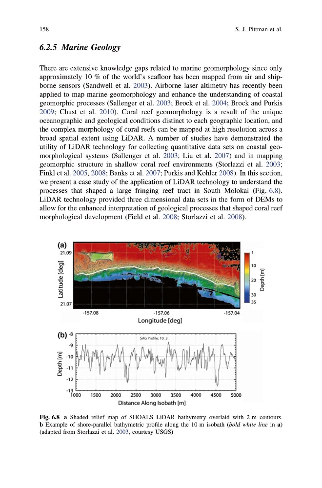
we present a case study of the application of LiDAR technology to understand the
processes that shaped a large fringing reef tract in South Molokai (Fig. 6.8).
LiDAR technology provided three dimensional data sets in the form of DEMs to
allow for the enhanced interpretation of geological processes that shaped coral reef
morphological development (Field et al. 2008; Storlazzi et al. 2008).
Fig. 6.8 a Shaded relief map of SHOALS LiDAR bathymetry overlaid with 2 m contours.
b Example of shore-parallel bathymetric profile along the 10 m isobath (bold white line in a)
(adapted from Storlazzi et al. 2003, courtesy USGS)
158
S. J. Pittman et al.
There are extensive knowledge gaps related to marine geomorphology since only
approximately 10 % of the world’s seafloor has been mapped from air and shipborne sensors (Sandwell et al. 2003). Airborne laser altimetry has recently been
applied to map marine geomorphology and enhance the understanding of coastal
geomorphic processes (Sallenger et al. 2003; Brock et al. 2004; Brock and Purkis
2009; Chust et al. 2010). Coral reef geomorphology is a result of the unique
oceanographic and geological conditions distinct to each geographic location, and
the complex morphology of coral reefs can be mapped at high resolution across a
broad spatial extent using LiDAR. A number of studies have demonstrated the
utility of LiDAR technology for collecting quantitative data sets on coastal geomorphological systems (Sallenger et al. 2003; Liu et al. 2007) and in mapping
geomorphic structure in shallow coral reef environments (Storlazzi et al. 2003;
Finkl et al. 2005, 2008; Banks et al. 2007; Purkis and Kohler 2008). In this section,
we present a case study of the application of LiDAR technology to understand the
processes that shaped a large fringing reef tract in South Molokai (Fig. 6.8).
LiDAR technology provided three dimensional data sets in the form of DEMs to
allow for the enhanced interpretation of geological processes that shaped coral reef
morphological development (Field et al. 2008; Storlazzi et al. 2008).
Fig. 6.8 a Shaded relief map of SHOALS LiDAR bathymetry overlaid with 2 m contours.
b Example of shore-parallel bathymetric profile along the 10 m isobath (bold white line in a)
(adapted from Storlazzi et al. 2003, courtesy USGS)
158
S. J. Pittman et al.