

Navassa, the highest fractal dimensions were quantified in areas characterized by
highest live coral cover (Zawada et al. 2010).
The high predictability of marine fauna across complex coral reef ecosystems
using LiDAR derivatives indicates that LiDAR is a useful tool for rapidly and costeffectively gathering broad scale data in support of conservation planning,
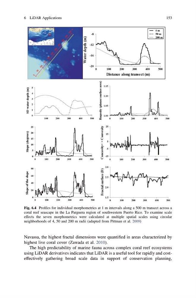
Fig. 6.4 Profiles for individual morphometrics at 1 m intervals along a 500 m transect across a
coral reef seascape in the La Parguera region of southwestern Puerto Rico. To examine scale
effects the seven morphometrics were calculated at multiple spatial scales using circular
neighborhoods of 4, 50 and 200 m radii (adapted from Pittman et al. 2009)
6 LiDAR Applications
153
highest live coral cover (Zawada et al. 2010).
The high predictability of marine fauna across complex coral reef ecosystems
using LiDAR derivatives indicates that LiDAR is a useful tool for rapidly and costeffectively gathering broad scale data in support of conservation planning,
Fig. 6.4 Profiles for individual morphometrics at 1 m intervals along a 500 m transect across a
coral reef seascape in the La Parguera region of southwestern Puerto Rico. To examine scale
effects the seven morphometrics were calculated at multiple spatial scales using circular
neighborhoods of 4, 50 and 200 m radii (adapted from Pittman et al. 2009)
6 LiDAR Applications
153