

specialised and costly than, for example, needed to process satellite imagery. An
example of a high-end 3-D visualization software is Fledermaus, manufactured by
IVS 3D. The cost and demanded expertise may render the processing of raw
LiDAR data at a level beyond the typical coral reef manager or scientist. An
exception to this trend is the USGS distributed software ‘ALPS’ (Airborne LiDAR
Processing System), which has been developed in an open-source programming
environment on a Linux platform. ALPS supports the exploration and processing
of LiDAR data acquired by the EAARL system in an interactive or batch mode.
Available at no-cost, ALPS encompasses the processing workflow to convert raw
LiDAR data to marine and terrestrial DEMs, including bare-earth and canopy
structure models. Manual interaction and interrogation of the raw EAARL laser
waveforms is also facilitated. The United States’ Naval Oceanographic Office
(NAVOCEANO) produce no-cost software which contain area-based-editing
(ABE) tools, but these focus only on visualization of the processed depth data and
associated waveforms, as well as down-look imagery.
In the United States, LiDAR technology is frequently used throughout the remote
sensing community. One reason for this being that a great deal of data are acquired by
government agencies and therefore must reside in the public domain. The Center for
LiDAR Information Coordination and Knowledge (CLICK) website (http://lidar.cr.
usgs.gov/) serves as a portal to information for accessing both terrestrial and marine
LiDAR data. NASA, NOAA, and USGS acquired soundings can all be obtained via
CLICK and the site includes a viewer to visualise the LiDAR data held within the
database. Further, the NOAA Digital Coast (http://csc.noaa.gov/digitalcoast/) serves
up both topographic and bathymetric LiDAR collected along the United States
coastline, and the NOAA National Geophysical Data Center (NGDC) serves DEMs
created from combined sonar and LiDAR data (http://ngdc.noaa.gov/).
5.3 Image Products and Environmental Variables
5.3.1 Bathymetric Products
LiDAR is not the only solution for remotely deriving water depth over coral reef
areas. Methods do exist for extracting bathymetry from visible-spectrum passive
remote sensing data (Chaps. 1–4). For multispectral imagery, these are based on the
differential spectral attenuation of light with wavelength by water (Lyzenga 1981;
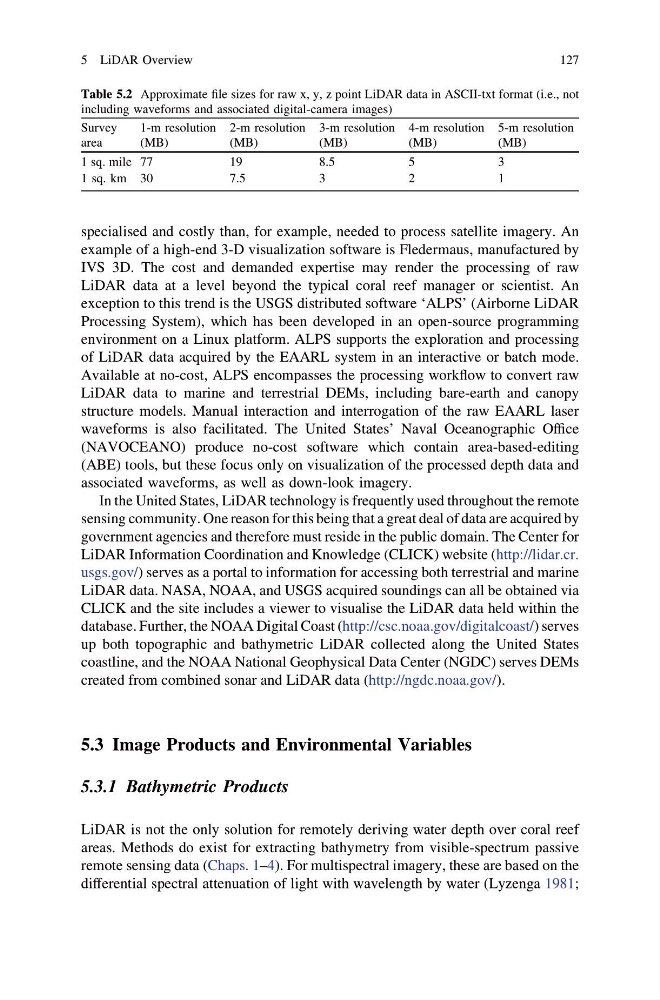
Table 5.2 Approximate file sizes for raw x, y, z point LiDAR data in ASCII-txt format (i.e., not
including waveforms and associated digital-camera images)
Survey
area
1-m resolution
(MB)
2-m resolution
(MB)
3-m resolution
(MB)
4-m resolution
(MB)
5-m resolution
(MB)
1 sq. mile 77
19
8.5
5
3
1 sq. km 30
7.5
3
2
1
5 LiDAR Overview
127
example of a high-end 3-D visualization software is Fledermaus, manufactured by
IVS 3D. The cost and demanded expertise may render the processing of raw
LiDAR data at a level beyond the typical coral reef manager or scientist. An
exception to this trend is the USGS distributed software ‘ALPS’ (Airborne LiDAR
Processing System), which has been developed in an open-source programming
environment on a Linux platform. ALPS supports the exploration and processing
of LiDAR data acquired by the EAARL system in an interactive or batch mode.
Available at no-cost, ALPS encompasses the processing workflow to convert raw
LiDAR data to marine and terrestrial DEMs, including bare-earth and canopy
structure models. Manual interaction and interrogation of the raw EAARL laser
waveforms is also facilitated. The United States’ Naval Oceanographic Office
(NAVOCEANO) produce no-cost software which contain area-based-editing
(ABE) tools, but these focus only on visualization of the processed depth data and
associated waveforms, as well as down-look imagery.
In the United States, LiDAR technology is frequently used throughout the remote
sensing community. One reason for this being that a great deal of data are acquired by
government agencies and therefore must reside in the public domain. The Center for
LiDAR Information Coordination and Knowledge (CLICK) website (http://lidar.cr.
usgs.gov/) serves as a portal to information for accessing both terrestrial and marine
LiDAR data. NASA, NOAA, and USGS acquired soundings can all be obtained via
CLICK and the site includes a viewer to visualise the LiDAR data held within the
database. Further, the NOAA Digital Coast (http://csc.noaa.gov/digitalcoast/) serves
up both topographic and bathymetric LiDAR collected along the United States
coastline, and the NOAA National Geophysical Data Center (NGDC) serves DEMs
created from combined sonar and LiDAR data (http://ngdc.noaa.gov/).
5.3 Image Products and Environmental Variables
5.3.1 Bathymetric Products
LiDAR is not the only solution for remotely deriving water depth over coral reef
areas. Methods do exist for extracting bathymetry from visible-spectrum passive
remote sensing data (Chaps. 1–4). For multispectral imagery, these are based on the
differential spectral attenuation of light with wavelength by water (Lyzenga 1981;
Table 5.2 Approximate file sizes for raw x, y, z point LiDAR data in ASCII-txt format (i.e., not
including waveforms and associated digital-camera images)
Survey
area
1-m resolution
(MB)
2-m resolution
(MB)
3-m resolution
(MB)
4-m resolution
(MB)
5-m resolution
(MB)
1 sq. mile 77
19
8.5
5
3
1 sq. km 30
7.5
3
2
1
5 LiDAR Overview
127