

Laser range-finders are similarly used in the marine realm as a payload on
manned or remotely operated submersibles. When ‘flown’ in close proximity to the
seabed, the LiDAR can be used to measure topography, and if spectrally calibrated,
also quantify seabed character based on reflectance and fluorescence (Reuter et al.
1995; Harsdorf et al. 1997). Such applications may be accompanied by the capture
of seabed video and sonar. Another well investigated application of both airborne
and submersible laser remote sensing is for fisheries surveys (Squire and Krumboltz
1981; Krekova et al. 1994; Churnside and Hunter 1997; Churnside et al. 2003).
Submarine fluorescence LiDAR is also used for the detection of oil spills and
floating chemicals on the sea surface (Reuter et al. 1995), as well as to estimate the
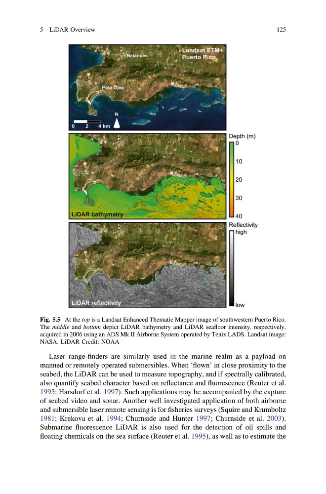
Fig. 5.5 At the top is a Landsat Enhanced Thematic Mapper image of southwestern Puerto Rico.
The middle and bottom depict LiDAR bathymetry and LiDAR seafloor intensity, respectively,
acquired in 2006 using an ADS Mk II Airborne System operated by Tenix LADS. Landsat image:
NASA. LiDAR Credit: NOAA
5 LiDAR Overview
125
manned or remotely operated submersibles. When ‘flown’ in close proximity to the
seabed, the LiDAR can be used to measure topography, and if spectrally calibrated,
also quantify seabed character based on reflectance and fluorescence (Reuter et al.
1995; Harsdorf et al. 1997). Such applications may be accompanied by the capture
of seabed video and sonar. Another well investigated application of both airborne
and submersible laser remote sensing is for fisheries surveys (Squire and Krumboltz
1981; Krekova et al. 1994; Churnside and Hunter 1997; Churnside et al. 2003).
Submarine fluorescence LiDAR is also used for the detection of oil spills and
floating chemicals on the sea surface (Reuter et al. 1995), as well as to estimate the
Fig. 5.5 At the top is a Landsat Enhanced Thematic Mapper image of southwestern Puerto Rico.
The middle and bottom depict LiDAR bathymetry and LiDAR seafloor intensity, respectively,
acquired in 2006 using an ADS Mk II Airborne System operated by Tenix LADS. Landsat image:
NASA. LiDAR Credit: NOAA
5 LiDAR Overview
125