

night when cloudy conditions are less pervasive. Night flights confer an added
benefit when turbidity conditions are high by reducing solar noise in the returned
waveforms.
5.2.2 Field-Deployed LiDAR
Beyond its more common airborne application, LiDAR can also be used to considerable effect in lower-cost field-mounted instruments that are relevant for coral
reef research. In their 500 million year tenure on Earth, reefs have built vast
carbonate edifices, through tectonics and sea-level change, many ancient examples
of which now sit on land (Wood 1999). The vertical faces of outcrops can be read
to reveal information on, for example, climate and sea-level cyclicity over geological time-scales. Outcrops have traditionally been examined through intensive
fieldwork, but more recently LiDAR range finders have been used to produce a 3D geological computer model of vertical rock formations (Bellian et al. 2005).
Analysis of time- and spectral-resolved laser signals permits the 3-D positioning of
the cliff face and, if not obscured by vegetation, classification based on the
reflectance characteristics of the rock. In this case, the LiDAR is tripod-mounted
and can aim its laser beam in a wide range; its head rotates horizontally, and a
mirror flips vertically. The laser measures the distance to the first object in its path.
As with airborne instruments, ground-based green LiDAR also have power constraints due to eye-safety issues.
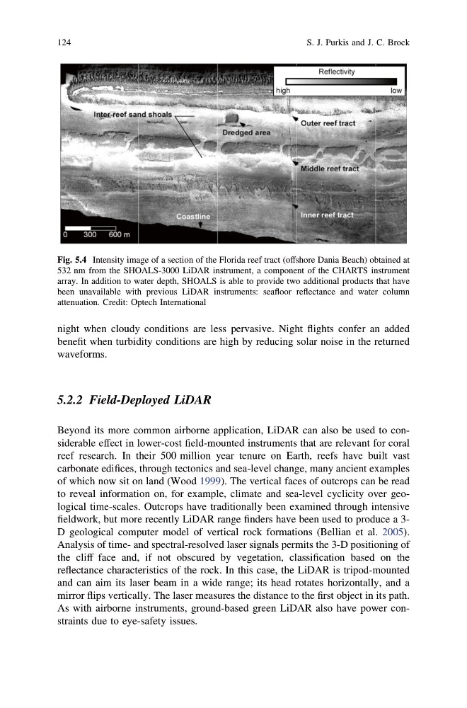
Fig. 5.4 Intensity image of a section of the Florida reef tract (offshore Dania Beach) obtained at
532 nm from the SHOALS-3000 LiDAR instrument, a component of the CHARTS instrument
array. In addition to water depth, SHOALS is able to provide two additional products that have
been unavailable with previous LiDAR instruments: seafloor reflectance and water column
attenuation. Credit: Optech International
124
S. J. Purkis and J. C. Brock
benefit when turbidity conditions are high by reducing solar noise in the returned
waveforms.
5.2.2 Field-Deployed LiDAR
Beyond its more common airborne application, LiDAR can also be used to considerable effect in lower-cost field-mounted instruments that are relevant for coral
reef research. In their 500 million year tenure on Earth, reefs have built vast
carbonate edifices, through tectonics and sea-level change, many ancient examples
of which now sit on land (Wood 1999). The vertical faces of outcrops can be read
to reveal information on, for example, climate and sea-level cyclicity over geological time-scales. Outcrops have traditionally been examined through intensive
fieldwork, but more recently LiDAR range finders have been used to produce a 3D geological computer model of vertical rock formations (Bellian et al. 2005).
Analysis of time- and spectral-resolved laser signals permits the 3-D positioning of
the cliff face and, if not obscured by vegetation, classification based on the
reflectance characteristics of the rock. In this case, the LiDAR is tripod-mounted
and can aim its laser beam in a wide range; its head rotates horizontally, and a
mirror flips vertically. The laser measures the distance to the first object in its path.
As with airborne instruments, ground-based green LiDAR also have power constraints due to eye-safety issues.
Fig. 5.4 Intensity image of a section of the Florida reef tract (offshore Dania Beach) obtained at
532 nm from the SHOALS-3000 LiDAR instrument, a component of the CHARTS instrument
array. In addition to water depth, SHOALS is able to provide two additional products that have
been unavailable with previous LiDAR instruments: seafloor reflectance and water column
attenuation. Credit: Optech International
124
S. J. Purkis and J. C. Brock