

13.4 Conclusion
In this chapter, we have reviewed the research status of using support vector
machines (SVM) for land cover mapping with special attention on heterogeneous
landscape types. Then, we have implemented this technique to map various land
cover types in an urban area from a satellite remote sensor image. Our studies
further confirm that SVM can significantly outperform the maximum likelihood
classifier (MLC), the most widely used pattern recognition method in the remote
sensing community. We found that SVM can significantly improve mapping
accuracy, particularly for spectrally and spatially complex land cover categories.
Acknowledgements The authors like to thank the Florida State University for the time release in
conducting this work. The research was partially supported by the Florida State University Council
on Research and Creativity, CAS/SAFEA International Partnership Program for Creative
Research Teams of “Ecosystem Processes and Services”, the Natural Science Foundation of
China through the grant “A Study on Environmental Impacts of Urban Landscape Changes and
Optimized Ecological Modeling” (ID 41230633).
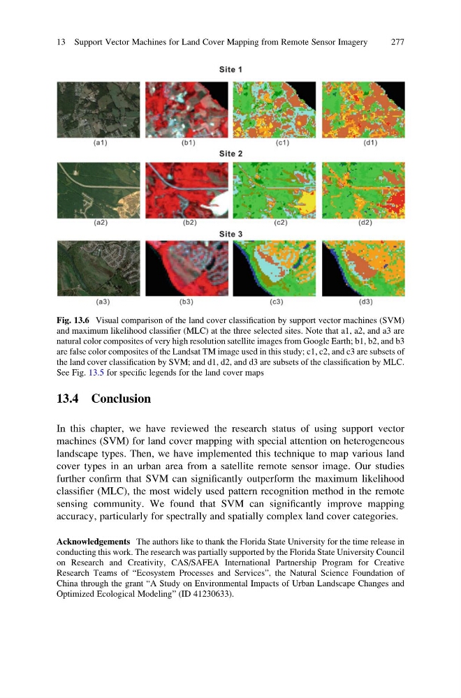
Fig. 13.6 Visual comparison of the land cover classification by support vector machines (SVM)
and maximum likelihood classifier (MLC) at the three selected sites. Note that a1, a2, and a3 are
natural color composites of very high resolution satellite images from Google Earth; b1, b2, and b3
are false color composites of the Landsat TM image used in this study; c1, c2, and c3 are subsets of
the land cover classification by SVM; and d1, d2, and d3 are subsets of the classification by MLC.
See Fig. 13.5 for specific legends for the land cover maps
13 Support Vector Machines for Land Cover Mapping from Remote Sensor Imagery
277
In this chapter, we have reviewed the research status of using support vector
machines (SVM) for land cover mapping with special attention on heterogeneous
landscape types. Then, we have implemented this technique to map various land
cover types in an urban area from a satellite remote sensor image. Our studies
further confirm that SVM can significantly outperform the maximum likelihood
classifier (MLC), the most widely used pattern recognition method in the remote
sensing community. We found that SVM can significantly improve mapping
accuracy, particularly for spectrally and spatially complex land cover categories.
Acknowledgements The authors like to thank the Florida State University for the time release in
conducting this work. The research was partially supported by the Florida State University Council
on Research and Creativity, CAS/SAFEA International Partnership Program for Creative
Research Teams of “Ecosystem Processes and Services”, the Natural Science Foundation of
China through the grant “A Study on Environmental Impacts of Urban Landscape Changes and
Optimized Ecological Modeling” (ID 41230633).
Fig. 13.6 Visual comparison of the land cover classification by support vector machines (SVM)
and maximum likelihood classifier (MLC) at the three selected sites. Note that a1, a2, and a3 are
natural color composites of very high resolution satellite images from Google Earth; b1, b2, and b3
are false color composites of the Landsat TM image used in this study; c1, c2, and c3 are subsets of
the land cover classification by SVM; and d1, d2, and d3 are subsets of the classification by MLC.
See Fig. 13.5 for specific legends for the land cover maps
13 Support Vector Machines for Land Cover Mapping from Remote Sensor Imagery
277