

to 0.143 (Yang 2011). We used this SVM configuration to classify the Gwinnett
subset of the 7-band TM image with the training samples described above. For
comparison purpose, we also used the same training samples to classify the same
image by using the maximum likelihood classifier (MLC) that has been widely
used. After the implementation of SVM and MLC, we combined the 20 spectral
classes into 10 information classes prior to the thematic accuracy assessment
(Fig. 13.5).
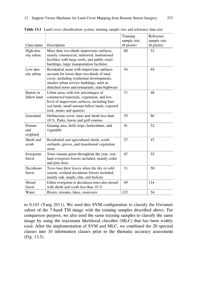
Table 13.1 Land cover classification system, training sample size and reference data size
Class name Description
Training
sample size
(# pixels)
Reference
sample size
(# pixels)
High-density urban
More than two-thirds impervious surfaces,
mainly commercial, industrial, institutional
facilities with large roofs, and public retail
buildings, large transportation facilities
60
52
Low-density urban
Residential areas with impervious surfaces
account for lower than two-thirds of total
cover, including residential developments,
smaller urban service buildings, such as
detached stores and restaurants, state highways
54
84
Barren or
fallow land
Urban areas with low percentages of
constructed materials, vegetation, and low
level of impervious surfaces, including bare
soil lands, small amount fallow lands, exposed
rock, mines and quarries
71
48
Grassland
Herbaceous cover, trees and shrub less than
10 %. Parks, lawns and golf courses
55
86
Pasture
and
cropland
Grazing area, field crops, horticulture, and
vegetable
41
52
Shrub and
scrub
Residential and agricultural shrub, scrub,
orchards, groves, and transitional vegetation
areas
27
47
Evergreen
forest
Trees remain green throughout the year, wetland evergreen forests included, mainly cedar
and pine trees
47
55
Deciduous
forest
Trees lose their leaves when the dry or cold
season, wetland deciduous forests included,
mainly oak, maple, elm, and hickory
31
50
Mixed
forest
Either evergreen or deciduous trees also mixed
with shrub and scrub less than 10 %
49
114
Water
Rivers, streams, lakes, reservoirs
125
54
13 Support Vector Machines for Land Cover Mapping from Remote Sensor Imagery
273
subset of the 7-band TM image with the training samples described above. For
comparison purpose, we also used the same training samples to classify the same
image by using the maximum likelihood classifier (MLC) that has been widely
used. After the implementation of SVM and MLC, we combined the 20 spectral
classes into 10 information classes prior to the thematic accuracy assessment
(Fig. 13.5).
Table 13.1 Land cover classification system, training sample size and reference data size
Class name Description
Training
sample size
(# pixels)
Reference
sample size
(# pixels)
High-density urban
More than two-thirds impervious surfaces,
mainly commercial, industrial, institutional
facilities with large roofs, and public retail
buildings, large transportation facilities
60
52
Low-density urban
Residential areas with impervious surfaces
account for lower than two-thirds of total
cover, including residential developments,
smaller urban service buildings, such as
detached stores and restaurants, state highways
54
84
Barren or
fallow land
Urban areas with low percentages of
constructed materials, vegetation, and low
level of impervious surfaces, including bare
soil lands, small amount fallow lands, exposed
rock, mines and quarries
71
48
Grassland
Herbaceous cover, trees and shrub less than
10 %. Parks, lawns and golf courses
55
86
Pasture
and
cropland
Grazing area, field crops, horticulture, and
vegetable
41
52
Shrub and
scrub
Residential and agricultural shrub, scrub,
orchards, groves, and transitional vegetation
areas
27
47
Evergreen
forest
Trees remain green throughout the year, wetland evergreen forests included, mainly cedar
and pine trees
47
55
Deciduous
forest
Trees lose their leaves when the dry or cold
season, wetland deciduous forests included,
mainly oak, maple, elm, and hickory
31
50
Mixed
forest
Either evergreen or deciduous trees also mixed
with shrub and scrub less than 10 %
49
114
Water
Rivers, streams, lakes, reservoirs
125
54
13 Support Vector Machines for Land Cover Mapping from Remote Sensor Imagery
273