

six non-thermal infrared bands, and 120 m for the thermal band. It was projected
into the Universal Transverse Mercator Zone 16N with NAD 83 as the horizontal
datum. Only six non-thermal infrared bands were used for land cover classification.
13.3.2 Classification Scheme and Training Samples
We designed a land use/cover classification scheme based on the Anderson scheme
(Anderson et al. 1976) and our field surveys across the Atlanta metropolitan area.
The study area covers a mosaic of different land use cover types, and our classification system includes ten major categories: high-density urban, low-density urban,
barren or fallow land, pasture and cropland, grassland, shrub and scrub, evergreen
forest, deciduous forest, mixed forest, and water (Table 13.1 and Fig. 13.4).
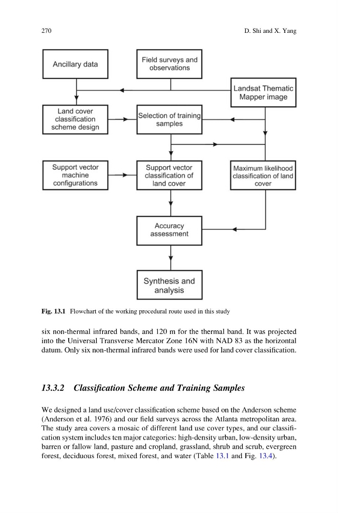
Fig. 13.1 Flowchart of the working procedural route used in this study
270
D. Shi and X. Yang
into the Universal Transverse Mercator Zone 16N with NAD 83 as the horizontal
datum. Only six non-thermal infrared bands were used for land cover classification.
13.3.2 Classification Scheme and Training Samples
We designed a land use/cover classification scheme based on the Anderson scheme
(Anderson et al. 1976) and our field surveys across the Atlanta metropolitan area.
The study area covers a mosaic of different land use cover types, and our classification system includes ten major categories: high-density urban, low-density urban,
barren or fallow land, pasture and cropland, grassland, shrub and scrub, evergreen
forest, deciduous forest, mixed forest, and water (Table 13.1 and Fig. 13.4).
Fig. 13.1 Flowchart of the working procedural route used in this study
270
D. Shi and X. Yang