

use and soil type raster files is different from the DEM. Therefore, the raster files of
land use and soil type have been resampled into the same grid-cell size raster file
with the DEM. The resample raster files are converted into ASCII files.
We present a framework for shallow landslide modeling characterized by rapidly moving flows of mixed soil and rock. These shallow landslides often occur
along saturated hill slopes under heavy or extreme rainfall. The purpose of this
Modeling System is mapping areas of potential slope instability over river
catchments.
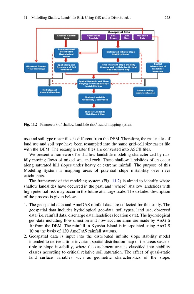
The framework of the modeling system (Fig. 11.2) is aimed to identify where
shallow landslides have occurred in the past, and “where” shallow landslides with
high potential risk may occur in the future at a large scale. The detailed description
of the process is given below.
1. The geospatial data and AmeDAS rainfall data are collected for this study. The
geospatial data includes hydrological geo-data, soil types, land use, observed
data (i.e. rainfall data, discharge data, landslides location data). The hydrological
geo-data including flow direction and flow accumulation are made by ArcGIS
10 from the DEM. The rainfall in Kyushu Island is interpolated using ArcGIS
10 on the basis of 120 AmeDAS rainfall stations.
2. Geospatial data is input into the distributed infinite slope stability model
intended to derive a time-invariant spatial distribution map of the areas susceptible to slope instability, where the catchment area is classified into stability
classes according to critical relative soil saturation. The effect of quasi-static
land surface variables such as geometric characteristics of the slope,
Fig. 11.2 Framework of shallow landslide risk/hazard mapping system
11 Modelling Shallow Landslide Risk Using GIS and a Distributed. . .
225
land use and soil type have been resampled into the same grid-cell size raster file
with the DEM. The resample raster files are converted into ASCII files.
We present a framework for shallow landslide modeling characterized by rapidly moving flows of mixed soil and rock. These shallow landslides often occur
along saturated hill slopes under heavy or extreme rainfall. The purpose of this
Modeling System is mapping areas of potential slope instability over river
catchments.
The framework of the modeling system (Fig. 11.2) is aimed to identify where
shallow landslides have occurred in the past, and “where” shallow landslides with
high potential risk may occur in the future at a large scale. The detailed description
of the process is given below.
1. The geospatial data and AmeDAS rainfall data are collected for this study. The
geospatial data includes hydrological geo-data, soil types, land use, observed
data (i.e. rainfall data, discharge data, landslides location data). The hydrological
geo-data including flow direction and flow accumulation are made by ArcGIS
10 from the DEM. The rainfall in Kyushu Island is interpolated using ArcGIS
10 on the basis of 120 AmeDAS rainfall stations.
2. Geospatial data is input into the distributed infinite slope stability model
intended to derive a time-invariant spatial distribution map of the areas susceptible to slope instability, where the catchment area is classified into stability
classes according to critical relative soil saturation. The effect of quasi-static
land surface variables such as geometric characteristics of the slope,
Fig. 11.2 Framework of shallow landslide risk/hazard mapping system
11 Modelling Shallow Landslide Risk Using GIS and a Distributed. . .
225