

8.3.1 Model Description and Parameterization
The ecosystem process model used in this study is the BIOME-BGC, which
simulates daily fluxes and storage of carbon, nitrogen, and water at specified
locations when provided with appropriate weather data, physiographic information,
and eco-physiological traits of the vegetation (Thornton et al. 2002). The sitespecific Biome-BGC model is free to use and the program is designed to operate
on the UNIX and Windows environment. The model was developed and is
maintained by the Numerical Terradynamics Simulation Group in the School of
Forestry at the University of Montana. Further development of the site-based model
has led to the grid-based (spatial) BIOME-BGC model by the Max-Planck-Institut
fu ¨r Biogeochemie and also freely available (Trusilova and Churkina 2008).
The Biome-BGC model operates by using at least three input files to compute a
simulation. The three basic input files include but are not limited to the initialization, meteorological, and eco-physiological data files. The initialization file provides general information about the simulation, including a description of the
physical characteristics of the simulation site, a description of the time-frame for
the simulation, the names of all the other required input files, the names for output
files that will be generated, and lists of variables to store in the output files. The
primary driving variables for estimating ecosystem processes with Biome-BGC are
daily meteorological data. The model also uses a list of parameters to differentiate
biomes on the basis of their eco-physiological characteristics. There are a total of
43 such parameters that must be specified for each model simulation. Most of the
required parameters can be measured in the field, or can be derived from other
measurements. For implementation at a particular site, field-based measurements
should be used to set the relevant eco-physiological constants of the model. A list of
basic inputs for each file type can be found in Thornton et al. (2002).
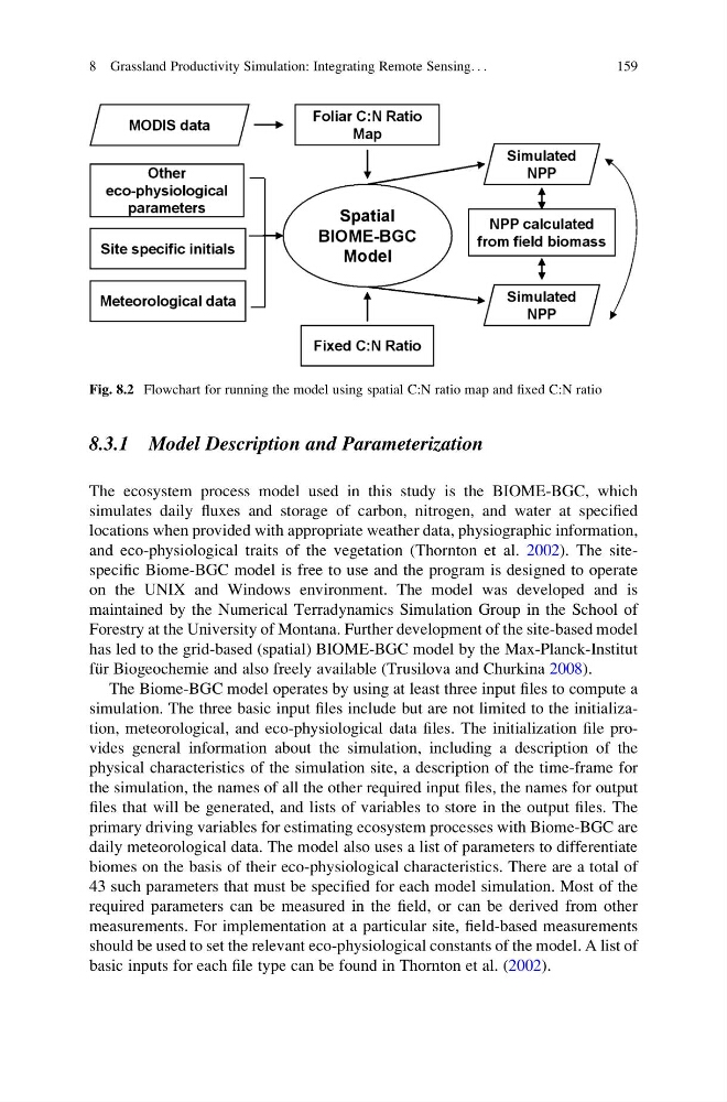
Fig. 8.2 Flowchart for running the model using spatial C:N ratio map and fixed C:N ratio
8 Grassland Productivity Simulation: Integrating Remote Sensing. . .
159
The ecosystem process model used in this study is the BIOME-BGC, which
simulates daily fluxes and storage of carbon, nitrogen, and water at specified
locations when provided with appropriate weather data, physiographic information,
and eco-physiological traits of the vegetation (Thornton et al. 2002). The sitespecific Biome-BGC model is free to use and the program is designed to operate
on the UNIX and Windows environment. The model was developed and is
maintained by the Numerical Terradynamics Simulation Group in the School of
Forestry at the University of Montana. Further development of the site-based model
has led to the grid-based (spatial) BIOME-BGC model by the Max-Planck-Institut
fu ¨r Biogeochemie and also freely available (Trusilova and Churkina 2008).
The Biome-BGC model operates by using at least three input files to compute a
simulation. The three basic input files include but are not limited to the initialization, meteorological, and eco-physiological data files. The initialization file provides general information about the simulation, including a description of the
physical characteristics of the simulation site, a description of the time-frame for
the simulation, the names of all the other required input files, the names for output
files that will be generated, and lists of variables to store in the output files. The
primary driving variables for estimating ecosystem processes with Biome-BGC are
daily meteorological data. The model also uses a list of parameters to differentiate
biomes on the basis of their eco-physiological characteristics. There are a total of
43 such parameters that must be specified for each model simulation. Most of the
required parameters can be measured in the field, or can be derived from other
measurements. For implementation at a particular site, field-based measurements
should be used to set the relevant eco-physiological constants of the model. A list of
basic inputs for each file type can be found in Thornton et al. (2002).
Fig. 8.2 Flowchart for running the model using spatial C:N ratio map and fixed C:N ratio
8 Grassland Productivity Simulation: Integrating Remote Sensing. . .
159