

of producing LIDAR vegetation map is as follows (Koarai et al. 2010b). The legend
of LIDAR vegetation map consists of the combination of difference in two seasons
(early deciduous trees, late deciduous trees and evergreen trees), vegetation height,
thickness of crown and deference of forest structure (single layer or multiple
layers).
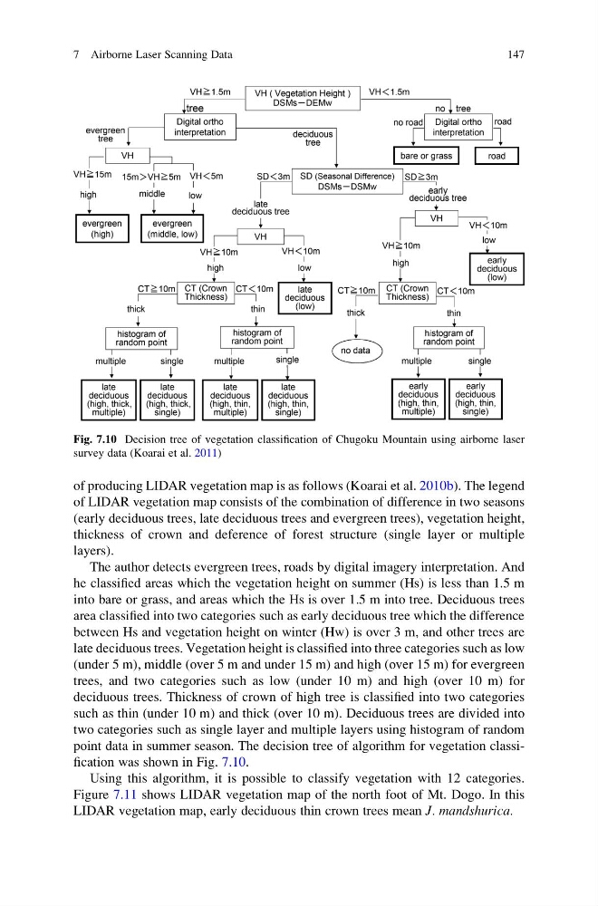
The author detects evergreen trees, roads by digital imagery interpretation. And
he classified areas which the vegetation height on summer (Hs) is less than 1.5 m
into bare or grass, and areas which the Hs is over 1.5 m into tree. Deciduous trees
area classified into two categories such as early deciduous tree which the difference
between Hs and vegetation height on winter (Hw) is over 3 m, and other trees are
late deciduous trees. Vegetation height is classified into three categories such as low
(under 5 m), middle (over 5 m and under 15 m) and high (over 15 m) for evergreen
trees, and two categories such as low (under 10 m) and high (over 10 m) for
deciduous trees. Thickness of crown of high tree is classified into two categories
such as thin (under 10 m) and thick (over 10 m). Deciduous trees are divided into
two categories such as single layer and multiple layers using histogram of random
point data in summer season. The decision tree of algorithm for vegetation classification was shown in Fig. 7.10.
Using this algorithm, it is possible to classify vegetation with 12 categories.
Figure 7.11 shows LIDAR vegetation map of the north foot of Mt. Dogo. In this
LIDAR vegetation map, early deciduous thin crown trees mean J. mandshurica.
Fig. 7.10 Decision tree of vegetation classification of Chugoku Mountain using airborne laser
survey data (Koarai et al. 2011)
7 Airborne Laser Scanning Data
147
of LIDAR vegetation map consists of the combination of difference in two seasons
(early deciduous trees, late deciduous trees and evergreen trees), vegetation height,
thickness of crown and deference of forest structure (single layer or multiple
layers).
The author detects evergreen trees, roads by digital imagery interpretation. And
he classified areas which the vegetation height on summer (Hs) is less than 1.5 m
into bare or grass, and areas which the Hs is over 1.5 m into tree. Deciduous trees
area classified into two categories such as early deciduous tree which the difference
between Hs and vegetation height on winter (Hw) is over 3 m, and other trees are
late deciduous trees. Vegetation height is classified into three categories such as low
(under 5 m), middle (over 5 m and under 15 m) and high (over 15 m) for evergreen
trees, and two categories such as low (under 10 m) and high (over 10 m) for
deciduous trees. Thickness of crown of high tree is classified into two categories
such as thin (under 10 m) and thick (over 10 m). Deciduous trees are divided into
two categories such as single layer and multiple layers using histogram of random
point data in summer season. The decision tree of algorithm for vegetation classification was shown in Fig. 7.10.
Using this algorithm, it is possible to classify vegetation with 12 categories.
Figure 7.11 shows LIDAR vegetation map of the north foot of Mt. Dogo. In this
LIDAR vegetation map, early deciduous thin crown trees mean J. mandshurica.
Fig. 7.10 Decision tree of vegetation classification of Chugoku Mountain using airborne laser
survey data (Koarai et al. 2011)
7 Airborne Laser Scanning Data
147