

7.5 Landscape Ecological Study of Chugoku Mountain
Using Lidar Data
The targeted area of Chugoku Mountain is the north foot of Mt. Dogo, Nichinan
Town, Tottori Prefecture. The author obtained 1 m grid DSM and DEM of 25 km
2 on
targeted area in November 2008, and obtained 0.5 m grid DSM of 2 km
2 on the north
foot of Mt. Dogo in August, 2009 (Fig. 7.8). Vegetation classification map with three
dimensional vegetation structure was produced by the combination of summer
season airborne laser survey data and autumn season airborne laser survey data.
The topographic analysis was done using autumn season airborne laser survey data.
Figure 7.9 depicts topographic counter map with 1 m interval on the north foot of
Mt. Dogo by airborne laser survey data and some pictures. It is possible to detect olden
iron sand mining sites (Kanna-Nagashi) with concave gentle slope area in mountain
area surrounded by artificially cutting steep slope, using the method of counter line
interpretation. The author interprets that areas A and B are olden Kana-Nagashi sites,
and areas C and D are artificial cannels for mineral classification by specific gravity
method on Kana-Nagashi site. In ground survey, J. mandshurica (kind of nuts) is
dominated in concave gentle slope which is interpreted as Kanna-Nagashi site.
7.5.1 Produce of LIDAR Vegitation Map
Vegetation classification has been carried out using three dimensional vegetation
structure detected by the difference between DSM data in two seasons. Algorithm
900
2 m (g . cc . ro)
2 m (g . cc . sm)
2 m (g . cv . sm)
2 m (m . cc . ro)
2 m (m . cc . sm)
2 m (m . cv . ro)
2 m (m . cv . sm)
2 m (s . cc . ro)
2 m (s . cc . sm)
2 m (s . cv . ro)
2 m (s . cv . sm)
2 m (g . cv . ro)
800
× 10
4
700
600
500
400
300
200
100
0
b a r e , g r a s s ,
P i n u s
p u m
i l a
d e c i d u o u s
( s i n g l e )
d e c i d u o u s
( m
u l t i )
e v e r g r e e n
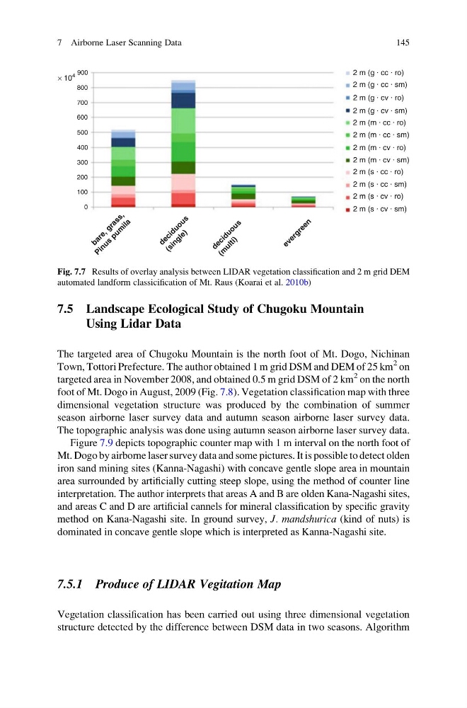
Fig. 7.7 Results of overlay analysis between LIDAR vegetation classification and 2 m grid DEM
automated landform classicification of Mt. Raus (Koarai et al. 2010b)
7 Airborne Laser Scanning Data
145
Using Lidar Data
The targeted area of Chugoku Mountain is the north foot of Mt. Dogo, Nichinan
Town, Tottori Prefecture. The author obtained 1 m grid DSM and DEM of 25 km
2 on
targeted area in November 2008, and obtained 0.5 m grid DSM of 2 km
2 on the north
foot of Mt. Dogo in August, 2009 (Fig. 7.8). Vegetation classification map with three
dimensional vegetation structure was produced by the combination of summer
season airborne laser survey data and autumn season airborne laser survey data.
The topographic analysis was done using autumn season airborne laser survey data.
Figure 7.9 depicts topographic counter map with 1 m interval on the north foot of
Mt. Dogo by airborne laser survey data and some pictures. It is possible to detect olden
iron sand mining sites (Kanna-Nagashi) with concave gentle slope area in mountain
area surrounded by artificially cutting steep slope, using the method of counter line
interpretation. The author interprets that areas A and B are olden Kana-Nagashi sites,
and areas C and D are artificial cannels for mineral classification by specific gravity
method on Kana-Nagashi site. In ground survey, J. mandshurica (kind of nuts) is
dominated in concave gentle slope which is interpreted as Kanna-Nagashi site.
7.5.1 Produce of LIDAR Vegitation Map
Vegetation classification has been carried out using three dimensional vegetation
structure detected by the difference between DSM data in two seasons. Algorithm
900
2 m (g . cc . ro)
2 m (g . cc . sm)
2 m (g . cv . sm)
2 m (m . cc . ro)
2 m (m . cc . sm)
2 m (m . cv . ro)
2 m (m . cv . sm)
2 m (s . cc . ro)
2 m (s . cc . sm)
2 m (s . cv . ro)
2 m (s . cv . sm)
2 m (g . cv . ro)
800
× 10
4
700
600
500
400
300
200
100
0
b a r e , g r a s s ,
P i n u s
p u m
i l a
d e c i d u o u s
( s i n g l e )
d e c i d u o u s
( m
u l t i )
e v e r g r e e n
Fig. 7.7 Results of overlay analysis between LIDAR vegetation classification and 2 m grid DEM
automated landform classicification of Mt. Raus (Koarai et al. 2010b)
7 Airborne Laser Scanning Data
145