

The second group of spatial data was determined for core areas. The group of
spatial data defined land use, however, from the urban architecture point of view.
Land use classes, also called functional classes, used in the analyses were residential, production, transport, recreational and other areas. They were processed from
image analysis and interpretations in core city areas. These land use areas were
derived using city plans (vector data), aerial orthophotos and satellite images (both
are raster data). City plans represent the actual state of land use of cities and plans
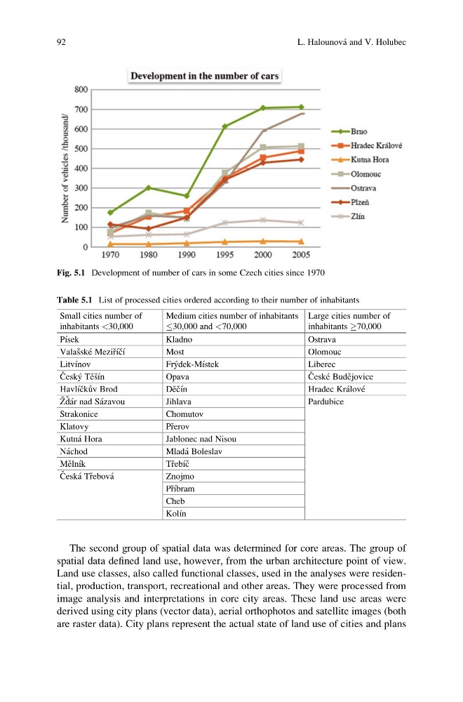
Fig. 5.1 Development of number of cars in some Czech cities since 1970
Table 5.1 List of processed cities ordered according to their number of inhabitants
Small cities number of
inhabitants <30,000
Medium cities number of inhabitants
30,000 and <70,000
Large cities number of
inhabitants !70,000
Pı ´sek
Kladno
Ostrava
Valas ˇske ´ Mezir ˇı ´c ˇı ´
Most
Olomouc
Litvı ´nov
Fry ´dek-Mı ´stek
Liberec
C ˇ esky ´ Te ˇs ˇı ´n
Opava
C ˇ eske ´ Bude ˇjovice
Havlı ´c ˇku ˚v Brod
De ˇc ˇı ´n
Hradec Kra ´love ´
Z ˇ d ˇ a ´r nad Sa ´zavou
Jihlava
Pardubice
Strakonice
Chomutov
Klatovy
Pr ˇerov
Kutna ´ Hora
Jablonec nad Nisou
Na ´chod
Mlada ´ Boleslav
Me ˇlnı ´k
T r
ˇebı ´c ˇ
C ˇ eska ´ Tr ˇebova ´
Znojmo
Pr ˇı ´bram
Cheb
Kolı ´n
92
L. Halounova ´ and V. Holubec
spatial data defined land use, however, from the urban architecture point of view.
Land use classes, also called functional classes, used in the analyses were residential, production, transport, recreational and other areas. They were processed from
image analysis and interpretations in core city areas. These land use areas were
derived using city plans (vector data), aerial orthophotos and satellite images (both
are raster data). City plans represent the actual state of land use of cities and plans
Fig. 5.1 Development of number of cars in some Czech cities since 1970
Table 5.1 List of processed cities ordered according to their number of inhabitants
Small cities number of
inhabitants <30,000
Medium cities number of inhabitants
30,000 and <70,000
Large cities number of
inhabitants !70,000
Pı ´sek
Kladno
Ostrava
Valas ˇske ´ Mezir ˇı ´c ˇı ´
Most
Olomouc
Litvı ´nov
Fry ´dek-Mı ´stek
Liberec
C ˇ esky ´ Te ˇs ˇı ´n
Opava
C ˇ eske ´ Bude ˇjovice
Havlı ´c ˇku ˚v Brod
De ˇc ˇı ´n
Hradec Kra ´love ´
Z ˇ d ˇ a ´r nad Sa ´zavou
Jihlava
Pardubice
Strakonice
Chomutov
Klatovy
Pr ˇerov
Kutna ´ Hora
Jablonec nad Nisou
Na ´chod
Mlada ´ Boleslav
Me ˇlnı ´k
T r
ˇebı ´c ˇ
C ˇ eska ´ Tr ˇebova ´
Znojmo
Pr ˇı ´bram
Cheb
Kolı ´n
92
L. Halounova ´ and V. Holubec