

55
if known, this can be mitigated by (a) flying higher resolution LiDAR (i.e., the number of pulses per m
2
), (b) decreasing the flying height (i.e., more laser power to get
weaker ground returns, but this limits the swath width), and (c) using a sensor which
can differentiate returns closer to one another along the path of the pulse. Some
older instruments can only differentiate returns more than 0.5–1 m from one another
along the path of the pulse. Another area where ground returns can be poorly defined
or classified is very steep terrain, particularly where there is also vegetation cover
(Bater and Coops 2009). It is recommended that for deriving elevation models, at
least 4 points per m
2
are acquired but if retrieving the vertical forest structure is of
Input Data
Large Dataset
No
Tile datasets for
processing
Yes
Ground return
classification
Define height
above ground
surface (i.e., veg
heights)
Interpolate DTM,
DSM and CHM
Calculate metrics
Metrics Raster
Raster outputs
Discrete returns or
waveforms
Discrete Return
Decompose
waveforms to find
discrete returns.
Waveform
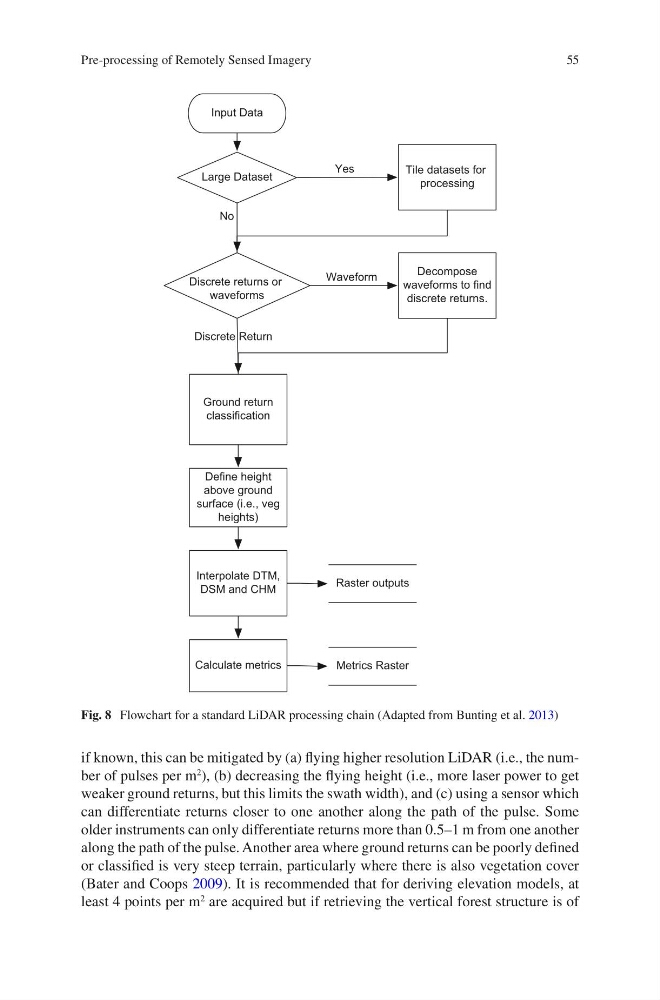
Fig. 8 Flowchart for a standard LiDAR processing chain (Adapted from Bunting et al. 2013)
Pre-processing of Remotely Sensed Imagery
if known, this can be mitigated by (a) flying higher resolution LiDAR (i.e., the number of pulses per m
2
), (b) decreasing the flying height (i.e., more laser power to get
weaker ground returns, but this limits the swath width), and (c) using a sensor which
can differentiate returns closer to one another along the path of the pulse. Some
older instruments can only differentiate returns more than 0.5–1 m from one another
along the path of the pulse. Another area where ground returns can be poorly defined
or classified is very steep terrain, particularly where there is also vegetation cover
(Bater and Coops 2009). It is recommended that for deriving elevation models, at
least 4 points per m
2
are acquired but if retrieving the vertical forest structure is of
Input Data
Large Dataset
No
Tile datasets for
processing
Yes
Ground return
classification
Define height
above ground
surface (i.e., veg
heights)
Interpolate DTM,
DSM and CHM
Calculate metrics
Metrics Raster
Raster outputs
Discrete returns or
waveforms
Discrete Return
Decompose
waveforms to find
discrete returns.
Waveform
Fig. 8 Flowchart for a standard LiDAR processing chain (Adapted from Bunting et al. 2013)
Pre-processing of Remotely Sensed Imagery