

41
should be provided with the image data by the data provider in a standard format
(format is commonly customised to each data provider) for ingestion to the appropriate processing software (e.g., Schwind et al. 2009).
Once the location of the instrument (whether aircraft or satellite) has been
defined and recorded, a model of the acquisition is defined in software. LiDAR
directly measures the 3-D component of the environment but for optical (e.g., multispectral and hyperspectral) and SAR, a Digital Elevation Model (DEM) is required
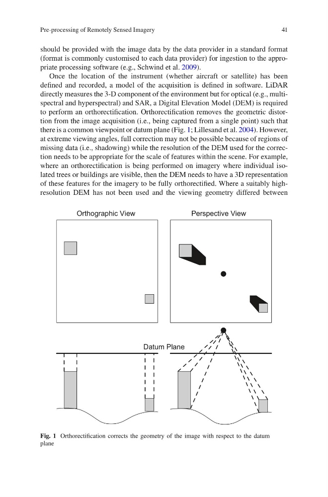
to perform an orthorectification. Orthorectification removes the geometric distortion from the image acquisition (i.e., being captured from a single point) such that
there is a common viewpoint or datum plane (Fig. 1; Lillesand et al. 2004). However,
at extreme viewing angles, full correction may not be possible because of regions of
missing data (i.e., shadowing) while the resolution of the DEM used for the correction needs to be appropriate for the scale of features within the scene. For example,
where an orthorectification is being performed on imagery where individual isolated trees or buildings are visible, then the DEM needs to have a 3D representation
of these features for the imagery to be fully orthorectified. Where a suitably highresolution DEM has not been used and the viewing geometry differed between
Datum Plane
Orthographic View
Perspective View
Fig. 1 Orthorectification corrects the geometry of the image with respect to the datum
plane
Pre-processing of Remotely Sensed Imagery
should be provided with the image data by the data provider in a standard format
(format is commonly customised to each data provider) for ingestion to the appropriate processing software (e.g., Schwind et al. 2009).
Once the location of the instrument (whether aircraft or satellite) has been
defined and recorded, a model of the acquisition is defined in software. LiDAR
directly measures the 3-D component of the environment but for optical (e.g., multispectral and hyperspectral) and SAR, a Digital Elevation Model (DEM) is required
to perform an orthorectification. Orthorectification removes the geometric distortion from the image acquisition (i.e., being captured from a single point) such that
there is a common viewpoint or datum plane (Fig. 1; Lillesand et al. 2004). However,
at extreme viewing angles, full correction may not be possible because of regions of
missing data (i.e., shadowing) while the resolution of the DEM used for the correction needs to be appropriate for the scale of features within the scene. For example,
where an orthorectification is being performed on imagery where individual isolated trees or buildings are visible, then the DEM needs to have a 3D representation
of these features for the imagery to be fully orthorectified. Where a suitably highresolution DEM has not been used and the viewing geometry differed between
Datum Plane
Orthographic View
Perspective View
Fig. 1 Orthorectification corrects the geometry of the image with respect to the datum
plane
Pre-processing of Remotely Sensed Imagery