

241
(senescent and productive grassland, water and burnt ground). For this reason, the
use of dense time-series of optical remote sensing data would provide a better overview of the changing states of vegetated and non-vegetated environments within the
IBMTCL. Whilst atmospheric correction of the Landsat sensor data was undertaken, smoke haze and cloud still limited reliable retrieval of surface reflectance for
some areas.
A further limitation of the land cover maps was that insufficient information on
the structural characteristics of forests that might influence tiger movements was
obtained, particularly in relation to the tree canopy density and canopy height. A
common approach to estimating canopy cover is to establish relationships between
ground based measurements and combinations of reflectance data. However, the
lack of ground data and seasonal changes in leaf cover prevented the generation of
reliable retrieval algorithms or use of those that are existing. Information on canopy
height was also not obtained although there is potential to retrieve this using NASA’s
Ice, Cloud, and land Elevation (ICESat) satellite Geoscience Laser Altimeter System
(GLAS). Future mapping could therefore focus on developing these products and
applying classification schemes that consider their inclusion such as the Food and
Agricultural Organisation’s (FAO) Land Cover Classification System (LCCS; see
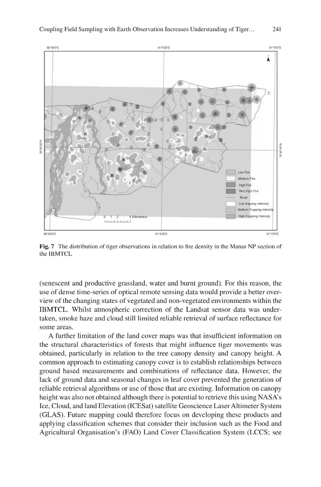
Fig. 7 The distribution of tiger observations in relation to fire density in the Manas NP section of
the IBMTCL
Coupling Field Sampling with Earth Observation Increases Understanding of Tiger…
(senescent and productive grassland, water and burnt ground). For this reason, the
use of dense time-series of optical remote sensing data would provide a better overview of the changing states of vegetated and non-vegetated environments within the
IBMTCL. Whilst atmospheric correction of the Landsat sensor data was undertaken, smoke haze and cloud still limited reliable retrieval of surface reflectance for
some areas.
A further limitation of the land cover maps was that insufficient information on
the structural characteristics of forests that might influence tiger movements was
obtained, particularly in relation to the tree canopy density and canopy height. A
common approach to estimating canopy cover is to establish relationships between
ground based measurements and combinations of reflectance data. However, the
lack of ground data and seasonal changes in leaf cover prevented the generation of
reliable retrieval algorithms or use of those that are existing. Information on canopy
height was also not obtained although there is potential to retrieve this using NASA’s
Ice, Cloud, and land Elevation (ICESat) satellite Geoscience Laser Altimeter System
(GLAS). Future mapping could therefore focus on developing these products and
applying classification schemes that consider their inclusion such as the Food and
Agricultural Organisation’s (FAO) Land Cover Classification System (LCCS; see
Fig. 7 The distribution of tiger observations in relation to fire density in the Manas NP section of
the IBMTCL
Coupling Field Sampling with Earth Observation Increases Understanding of Tiger…