

186
karroo. The vegetation structure is a typical semi-closed bushland, with a low grass
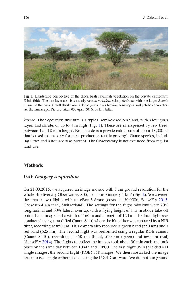
layer, and shrubs of up to 4 m high (Fig. 1). These are interspersed by few trees,
between 4 and 8 m in height. Erichsfelde is a private cattle farm of about 13,000 ha
that is used extensively for meat production (cattle grazing). Game species, including Oryx and Kudu are also present. The Observatory is not excluded from regular
land-use.
Methods
UAV Imagery Acquisition
On 21.03.2016, we acquired an image mosaic with 5 cm ground resolution for the
whole Biodiversity Observatory S05, i.e. approximately 1 km
2
(Fig. 2). We covered
the area in two flights with an eBee 3 drone (costs ca. 30.000€, SenseFly 2015,
Cheseaux-Lausanne, Switzerland). The settings for the flight missions were 70%
longitudinal and 60% lateral overlap, with a flying height of 115 m above take-off
point. Each image had a width of 160 m and a length of 120 m. The first flight was
conducted using a modified Canon S110 where the blue filter was replaced by a NIR
filter, recording at 850 nm. This camera also recorded a green band (550 nm) and a
red band (625 nm). The second flight was performed using a regular RGB camera
(Canon S110), recording at 450 nm (blue), 520 nm (green) and 660 nm (red)
(SenseFly 2014). The flights to collect the images took about 30 min each and took
place on the same day between 10h45 and 12h00. The first flight (NIR) yielded 411
single images; the second flight (RGB) 358 images. We then mosaicked the image
sets into two single orthomosaics using the PiX4D software. We did not use ground
Fig. 1 Landscape perspective of the thorn bush savannah vegetation on the private cattle-farm
Erichsfelde. The tree layer consists mainly Acacia mellifera subsp. detinens with one larger Acacia
tortilis in the back. Small shrubs and a dense grass layer leaving some open soil patches characterize the landscape. Picture taken 05. April 2016, by L. Naftal
J. Oldeland et al.
karroo. The vegetation structure is a typical semi-closed bushland, with a low grass
layer, and shrubs of up to 4 m high (Fig. 1). These are interspersed by few trees,
between 4 and 8 m in height. Erichsfelde is a private cattle farm of about 13,000 ha
that is used extensively for meat production (cattle grazing). Game species, including Oryx and Kudu are also present. The Observatory is not excluded from regular
land-use.
Methods
UAV Imagery Acquisition
On 21.03.2016, we acquired an image mosaic with 5 cm ground resolution for the
whole Biodiversity Observatory S05, i.e. approximately 1 km
2
(Fig. 2). We covered
the area in two flights with an eBee 3 drone (costs ca. 30.000€, SenseFly 2015,
Cheseaux-Lausanne, Switzerland). The settings for the flight missions were 70%
longitudinal and 60% lateral overlap, with a flying height of 115 m above take-off
point. Each image had a width of 160 m and a length of 120 m. The first flight was
conducted using a modified Canon S110 where the blue filter was replaced by a NIR
filter, recording at 850 nm. This camera also recorded a green band (550 nm) and a
red band (625 nm). The second flight was performed using a regular RGB camera
(Canon S110), recording at 450 nm (blue), 520 nm (green) and 660 nm (red)
(SenseFly 2014). The flights to collect the images took about 30 min each and took
place on the same day between 10h45 and 12h00. The first flight (NIR) yielded 411
single images; the second flight (RGB) 358 images. We then mosaicked the image
sets into two single orthomosaics using the PiX4D software. We did not use ground
Fig. 1 Landscape perspective of the thorn bush savannah vegetation on the private cattle-farm
Erichsfelde. The tree layer consists mainly Acacia mellifera subsp. detinens with one larger Acacia
tortilis in the back. Small shrubs and a dense grass layer leaving some open soil patches characterize the landscape. Picture taken 05. April 2016, by L. Naftal
J. Oldeland et al.