

125
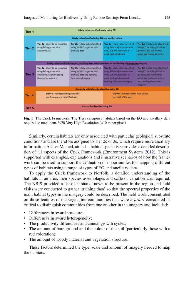
Similarly, certain habitats are only associated with particular geological substrate
conditions and are therefore assigned to Tier 2c or 3c, which require more ancillary
information. A User Manual, aimed at habitat specialists provides a detailed description of all aspects of the Crick Framework (Environment Systems 2012). This is
supported with examples, explanations and illustrative scenarios of how the framework can be used to support the evaluation of opportunities for mapping different
types of habitats using a range of types of EO and ancillary data.
To apply the Crick framework to Norfolk, a detailed understanding of the
habitats in an area, their species assemblages and scale of variation was required.
The NBIS provided a list of habitats known to be present in the region and field
visits were conducted to gather ‘training data’ so that the spectral properties of the
main habitat types in the imagery could be described. The field work concentrated
on those features of the vegetation communities that were a priori considered as
critical to distinguish communities from one another in the imagery and included:
• Differences in sward structure;
• Differences in sward heterogeneity;
• The productivity differences and annual growth cycles;
• The amount of bare ground and the colour of the soil (particularly those with a
red coloration);
• The amount of woody material and vegetation structure.
These factors determined the type, scale and amount of imagery needed to map
the habitats.
Fig. 1 The Crick Framework: The Tiers categorise habitats based on the EO and ancillary data
required to map them. VHR Very High Resolution (<10 m per pixel)
Integrated Monitoring for Biodiversity Using Remote Sensing: From Local…
Similarly, certain habitats are only associated with particular geological substrate
conditions and are therefore assigned to Tier 2c or 3c, which require more ancillary
information. A User Manual, aimed at habitat specialists provides a detailed description of all aspects of the Crick Framework (Environment Systems 2012). This is
supported with examples, explanations and illustrative scenarios of how the framework can be used to support the evaluation of opportunities for mapping different
types of habitats using a range of types of EO and ancillary data.
To apply the Crick framework to Norfolk, a detailed understanding of the
habitats in an area, their species assemblages and scale of variation was required.
The NBIS provided a list of habitats known to be present in the region and field
visits were conducted to gather ‘training data’ so that the spectral properties of the
main habitat types in the imagery could be described. The field work concentrated
on those features of the vegetation communities that were a priori considered as
critical to distinguish communities from one another in the imagery and included:
• Differences in sward structure;
• Differences in sward heterogeneity;
• The productivity differences and annual growth cycles;
• The amount of bare ground and the colour of the soil (particularly those with a
red coloration);
• The amount of woody material and vegetation structure.
These factors determined the type, scale and amount of imagery needed to map
the habitats.
Fig. 1 The Crick Framework: The Tiers categorise habitats based on the EO and ancillary data
required to map them. VHR Very High Resolution (<10 m per pixel)
Integrated Monitoring for Biodiversity Using Remote Sensing: From Local…