

110
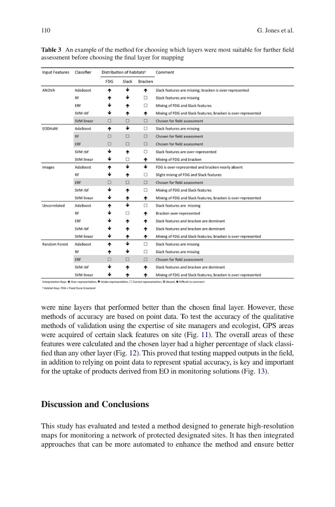
were nine layers that performed better than the chosen final layer. However, these
methods of accuracy are based on point data. To test the accuracy of the qualitative
methods of validation using the expertise of site managers and ecologist, GPS areas
were acquired of certain slack features on site (Fig. 11). The overall areas of these
features were calculated and the chosen layer had a higher percentage of slack classified than any other layer (Fig. 12). This proved that testing mapped outputs in the field,
in addition to relying on point data to represent spatial accuracy, is key and important
for the uptake of products derived from EO in monitoring solutions (Fig. 13).
Discussion and Conclusions
This study has evaluated and tested a method designed to generate high-resolution
maps for monitoring a network of protected designated sites. It has then integrated
approaches that can be more automated to enhance the method and ensure better
Table 3 An example of the method for choosing which layers were most suitable for further field
assessment before choosing the final layer for mapping
G. Jones et al.
were nine layers that performed better than the chosen final layer. However, these
methods of accuracy are based on point data. To test the accuracy of the qualitative
methods of validation using the expertise of site managers and ecologist, GPS areas
were acquired of certain slack features on site (Fig. 11). The overall areas of these
features were calculated and the chosen layer had a higher percentage of slack classified than any other layer (Fig. 12). This proved that testing mapped outputs in the field,
in addition to relying on point data to represent spatial accuracy, is key and important
for the uptake of products derived from EO in monitoring solutions (Fig. 13).
Discussion and Conclusions
This study has evaluated and tested a method designed to generate high-resolution
maps for monitoring a network of protected designated sites. It has then integrated
approaches that can be more automated to enhance the method and ensure better
Table 3 An example of the method for choosing which layers were most suitable for further field
assessment before choosing the final layer for mapping
G. Jones et al.