

136
Omar Boucelma, Mehdi Essid, and Yassine Lassoued
7.3.1 Data Sources and Schemas
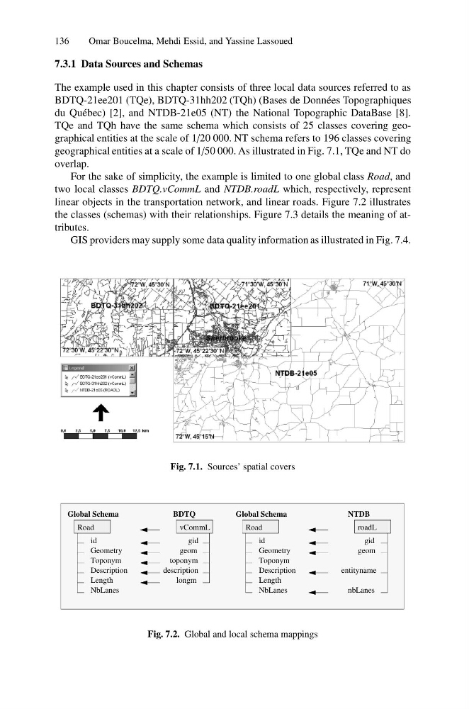
The example used in this chapter consists of three local data sources referred to as
BDTQ-21ee201 (TQe), BDTQ-31hh202 (TQh) (Bases de Donn´ ees Topographiques
du Qu´ ebec) [2], and NTDB-21e05 (NT) the National Topographic DataBase [8].
TQe and TQh have the same schema which consists of 25 classes covering geographical entities at the scale of 1/20 000. NT schema refers to 196 classes covering
geographical entities at a scale of 1/50 000. As illustrated in Fig. 7.1, TQe and NT do
overlap.
For the sake of simplicity, the example is limited to one global class Road, and
two local classes BDTQ.vCommL and NTDB.roadL which, respectively, represent
linear objects in the transportation network, and linear roads. Figure 7.2 illustrates
the classes (schemas) with their relationships. Figure 7.3 details the meaning of attributes.
GIS providers may supply some data quality information as illustrated in Fig. 7.4.
Fig. 7.1. Sources’ spatial covers
BDTQ
description
roadL
NTDB
nbLanes
toponym
geom
gid
geom
gid
entityname
Global Schema
Road
id
Description
Geometry
Toponym
Length
NbLanes
Global Schema
Road
id
Description
Geometry
Toponym
Length
NbLanes
longm
vCommL
Fig. 7.2. Global and local schema mappings
Omar Boucelma, Mehdi Essid, and Yassine Lassoued
7.3.1 Data Sources and Schemas
The example used in this chapter consists of three local data sources referred to as
BDTQ-21ee201 (TQe), BDTQ-31hh202 (TQh) (Bases de Donn´ ees Topographiques
du Qu´ ebec) [2], and NTDB-21e05 (NT) the National Topographic DataBase [8].
TQe and TQh have the same schema which consists of 25 classes covering geographical entities at the scale of 1/20 000. NT schema refers to 196 classes covering
geographical entities at a scale of 1/50 000. As illustrated in Fig. 7.1, TQe and NT do
overlap.
For the sake of simplicity, the example is limited to one global class Road, and
two local classes BDTQ.vCommL and NTDB.roadL which, respectively, represent
linear objects in the transportation network, and linear roads. Figure 7.2 illustrates
the classes (schemas) with their relationships. Figure 7.3 details the meaning of attributes.
GIS providers may supply some data quality information as illustrated in Fig. 7.4.
Fig. 7.1. Sources’ spatial covers
BDTQ
description
roadL
NTDB
nbLanes
toponym
geom
gid
geom
gid
entityname
Global Schema
Road
id
Description
Geometry
Toponym
Length
NbLanes
Global Schema
Road
id
Description
Geometry
Toponym
Length
NbLanes
longm
vCommL
Fig. 7.2. Global and local schema mappings